Overview
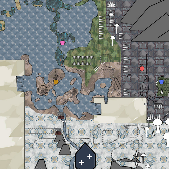
Introducing an improved and interactive version of Nemo’s infamous “rough map” of Meadow – which is ironic, since it’s incredibly detailed.
The Map, Instructions and Features

The map was created as a collaboration between Nemo and myself. The base map was drawn entirely by Nemo based on precise borders and precisely positioned landmarks. I refined the map, ported it for web usage and coded the application.
We decided on distributing it as a web application mainly based on Leaflet.js, a simple PHP framework and an almighty database.
It is optimized for working on big screens (1920×1080) and is image-heavy, so a proper internet connection highly improves usability.
It can be accessed here: [link]
You might want to directly add it to your bookmarks 😉
Usage of the map is fairly intuitive.
- You can drag the map across by clicking and holding the left mouse button.
- You can zoom in using the mouse wheel, the buttons in the top left corner or by double clicking (this is only zooming in).
- You can switch between overworld view and cave/underground view by clicking on the view button at the top right and selecting the desired view OR by simply clicking on any cave entrance. This will directly open the corresponding level of cave.
- When in cave view, you can switch between cave levels by clicking on the up/downwards stairs in the caves.
- By clicking on the right side of the bottom panel, you can open the filter menu, which allows you to display or hide specific layers.
- Clicking on objects which have a pointer cursor
when hovering over them opens a popup which provides you with more information on the object and – in most cases – an in game screenshot.
- Clicking on “Add Marker” allows you to add own markers to the map (either by simply clicking or entering in game coordinates). Currently, six colors can be used. “Clear All” removes all set markers.
- Clicking on “Export” downloads the map as an image file, with all currently selected layers and custom markers.
- Note: The map’s North is not the game’s North (in case you use the in game map/radar). In game North corresponds to the map’s West. This will be changed in future.

- Borders, proportions and all markers are based on in game coordinates and thus have a very high accuracy (was trying to use a unit here – let’s say by half the diameter of an obelisk).
- Features in game textures, usage approved by the M&D team.
- Features a fully-integrated underground map with three levels (for the spiral cave).
- Next to area markings, trees and rocks/mountains, the map features rises, inclines, foliage (puffballs/catnip), cave entrances, landmarks, secret spots (for achievements), statues, (not all) obelisk spawns and all types of fruit trees. These can be filtered.
- Provides image material and/or detailed information on landmarks, fruit trees, statues and secret spots.
- You can add own markers and export the map with any constellation of filters and added markers as a PNG image.
- Will constantly be kept up to date with new content (such as statues or new land masses) and improved upon by Nemo and myself.

Upcoming Features
Following features will be implemented in future, in no particular order. Bold features require a high workload.
- High essence spawns (Fabled Flower/Mushrooms/Lilypads, Golden Crystals)
- Adding textures to underground map
- Rotation of map to fit actual in game North (currently the map’s North is the game’s East)
Change Log
- Implemented elephant calf statues
- Implemented vulture statues
- Added six missing shelters. Thanks to TrottingHeart from the Meadow Discord[discord.gg] for pointing them out!
- Implemented fully functional multi-layered underground map
- Implemented antelope statues
- Implemented Obelisk Spawns — these will be updated in future since they are not complete, the map currently contains 88 spawns
- Added option to add markers in six different colors
- Adjusted size of markers and icons to scale with zoom level of map, making the map more tidy when zooming out far
- Fixed a bug that caused the exported map to not be centered after panning and zooming
- Fixed a compilation artifact in the top left corner
- Fixed bug from preceding update which caused the map to crash when zooming and severe performance issues in Chrome by stashing unneccessary transition animations
- Added locations of all shelters (small caves) including screenshots
- You can now zoom out much further and see a larger part of the map
- The exported image is now of higher quality
- When exporting, a loading screen is now shown
- Some small color changes
- Added new tiger statues
- Implemented feature allowing setting own markers on the map.
- Implemented feature allowing export of map. This downloads an image file with all current layers and custom markers. Note: Please allow some time for image compilation and download.
- Implemented option to disable game textures on map (fallback to white version with season shading by Nemo)
- Fixed false terrain in fall biome mountains.
- Initial release of the map!
- Corresponds to game version of November 2nd, 2020.