Overview
Hi racers, in this guide I want to show you where all the in-game stages are in the real world. I’m including a satellite image, coordinates (every coordinate points to the middle of the stage) and a stage map to each stage. Hope you enjoy it – like it if you liked it! :)As of 12.12.2015, I added Swedish stages, therefore the guide is now complete! If we get more rally stages (which I really hope we’ll do), I’ll update my guide to include them.Satellite images: from Google MapsStage maps: from dirtgame.com and from katagatame_’s guide: http://steamcommunity.com/sharedfiles/filedetails/?id=445493282I’d like to say thanks to my friend BlackDevil, who helped me with finding the locations (Greece, Wales, Monaco) in the pre-released period; to Party Magician, who colored start and finish lines on Germany stage maps. Please note: the guide may take some time to load as every stage is an image. Click on them to see them in high-resolution.
[Rally] Wales – Powys
Google Maps: [link]
Coordinates: 52.466672, -3.701874
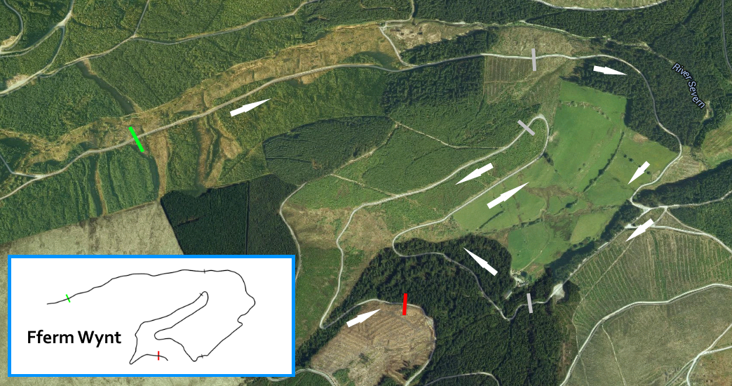
Coordinates: 52.463600, -3.683173

Coordinates: 52.458324, -3.680120

Coordinates: 52.455670, -3.714302

The same stages, River Severn Valley starts at West, Bronfelon starts at East.
Coordinates: 52.463626, -3.690961

The same stages, Sweet Lamb starts at West, Geufron Forest starts at East.
Coordinates: 52.454573, -3.702247

[Rally] Monaco – Monte Carlo
Google Maps: [link]
Coordinates: 43.971316, 7.404376

Coordinates: 43.953335, 7.413511

Coordinates: 43.980651, 7.369483
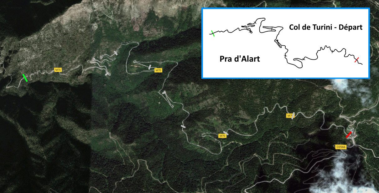
Coordinates: 43.984994, 7.356719

Coordinates: 43.979678, 7.379538

Coordinates: 43.960496, 7.413581

[Rally] Greece – Argolis
Google Maps: [link]
Coordinates: 37.778090, 22.522437

Coordinates: 37.791571, 22.508843

Coordinates: 37.773769, 22.562302

Coordinates: 37.763482, 22.556709

Coordinates: 37.771402, 22.563781

Coordinates:
[Rally] Germany – Baumholder
Google Maps: [link]
Coordinates: 49.668664, 7.329232

Coordinates: 49.653166, 7.330962

Coordinates: 49.644457, 7.327375

Coordinates: 49.641834, 7.329370

Coordinates: 49.648349, 7.320371

Coordinates: 49.650867, 7.332581

[Rally] Finland – Jämsä
Coordinates: 61.755822, 25.020759

Coordinates: 61.762231, 24.946659

Coordinates: 61.748340, 25.032445
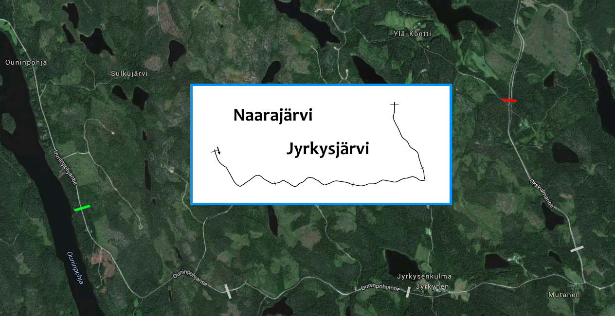
Coordinates: 61.791487, 25.096731

Coordinates: 61.791099, 25.078824

Coordinates: 61.790121, 25.109080

[Rally] Sweden – Värmland
Google Maps: [link]
Coordinates: 60.028021, 13.310248

Coordinates: 60.050717, 13.348350

Coordinates: 60.017659, 13.298765

Coordinates: 60.045268, 13.278542

Coordinates: 60.034912, 13.262802

Coordinates: 60.068830, 13.308918

[Hillclimb] USA – Pikes Peak
Google Maps: [link]
Coordinates: 38.907544, -105.054221

Coordinates: 38.874359, -105.071235

Coordinates: 38.848859, -105.057872

Coordinates: 38.865586, -105.065808

[RX] England – Lydden Hill
Coordinates: 51.179484, 1.197760

[RX] Sweden – Höljes
Coordinates: 60.917761, 12.553576

[RX] Norway – Hell
Coordinates: 63.405374, 10.919168
