
Overview
Updated 3 February 2021. Maps for some Train Simulator routes. I hope you will find them useful when setting up Quick Drive, or when creating a scenario.
Introduction
Friends know me for my terrible sense of direction and pathetic knowledge of where important places are in the world. Not every Train Simulator route comes with a handy map or diagram in the manual, so I get lost easily.
To help myself out I’ve made a few maps. I am sharing them so maybe someone else will also find them useful. They’re not pretty, but they do the job and help when setting up Quick Drive, or when creating a scenario.
At the very least I’ve named every station, and sometimes also sidings and yards, especially on routes that aren’t exclusively commuter trains.
All routes are available on Steam unless otherwise indicated.
Due to the size and level of detail on these maps, be sure to view them at full size.
Note that some parts of a route may not have any scenery. You can still drive on those parts, there is just not much to see other than track in endless grassy fields. These sections of the route are never advertised on the store page, but are included anyway so that route builders can have a go at them. I may have indicated which parts of the route lack scenery. If an electrified route has any unelectrified parts, I’ll indicate where they are so you know what type of train to pick for it.
- 3 February 2021: Updated the S25 Through the Heart of Berlin / Mitten durch Berlin map with red dots to indicate which stations have Zp9 and Zp10 signals
- 31 January 2021: Added S25 Through the Heart of Berlin / Mitten durch Berlin
- 21 January 2021: Minor text updates
- 19 January 2021: Text updates to the Köblitzer Bergland V3 section
- 16 January 2020: Added Im Köblitzer Bergland V3 Reloaded
- 7 July 2017: Added Western Lines of Scotland
- 19 June 2017: Added link to Purno’s diagrams.
- 19 May 2017: Added Projekt Freiberg and Konstanz-Villingen.
- 27 April 2017: Added some links to the “other maps and diagrams” section.
- 22 April 2017: It’s been a while 🙂 Minor changes to the text on this page, some links added to the “Official Maps” section.
- 23 October 2015: Added Soldier Summit.
- 28 September 2015: Added Weardale and Teesdale Network.
- 27 September 2015: Added Mannheim-Karlsruhe and Raquette Lake Railway
- 8 September 2015: Added South London to Brighton
- 30 July 2015: Added a chapter on official maps that come with the routes.
- 9 May 2015: Added Ruhr-Sieg Line
- 8 May 2015: Added Seebergbahn
- 25 April 2015: Added Berlin-Wittenberg
- 18 April 2015: Added Majestic Falls
- 23 March 2015: Added NEC: New York – New Haven
- 20 March 2015: Added Cajon Pass & London – Faversham.
- 7 March 2015: Added Stevens Pass.
- 3 March 2015: Added Köln – Düsseldorf.
- 1 March 2015: Added München – Augsburg.
- 25 February 2015: Added München – Garmisch-Partenkirchen.
- 22 February 2015: Added GEML London – Ipswich.
Requests and upcoming maps
I can only make maps for routes I own. If you want me to make a map of a specific route that I don’t own, here’s the deal: buy me the route and I’ll make the map 😉
I own the following routes and may make maps for them. I make no guarantees that I actually will. Routes that have no maps whatsoever in the manual will probably get priority. In no particular order:
- Three Country Corner Route. The manual[www.railsimulator.com] has a basic map.
- ECML North East (A free mod for Newcastle-York[www.dpsimulation.org.uk] putting the line into the modern era, adding electrification and a whole bunch of extra lines). I will probably do this route once the extension to Leeds is released.
- Portsmouth Direct Line (Woking-Portsmouth). This one has lots of extra branches with no scenery. Some diagrams can be found in the manual[www.railsimulator.com].
- WCML Over Shap – Has a map in the manual[www.railsimulator.com] but it doesn’t feature the yards and Ministry of Defense areas. I will include the workshop’s free Extension to Windermere
- Cologne to Koblenz – Has a map in the manual[www.railsimulator.com] too, but it’s also a bit limited (no yards)
GEML London – Ipswich

Notes:
- The line from Witham to Braintree is a single track branch, but still electrified.
- The line from Ipswich to Felixstowe is an unelectrified single track branch.
- The line from Manningtree to Harwich Town has no scenery.
There is a commercial third party product available from JustTrains[www.justtrains.net] which adds scenery to the Manningtree-Harwich Town section.
London to Brighton

Don’t forget to check the manual for a height diagram.
London to Faversham High Speed (and Sheerness Branch)
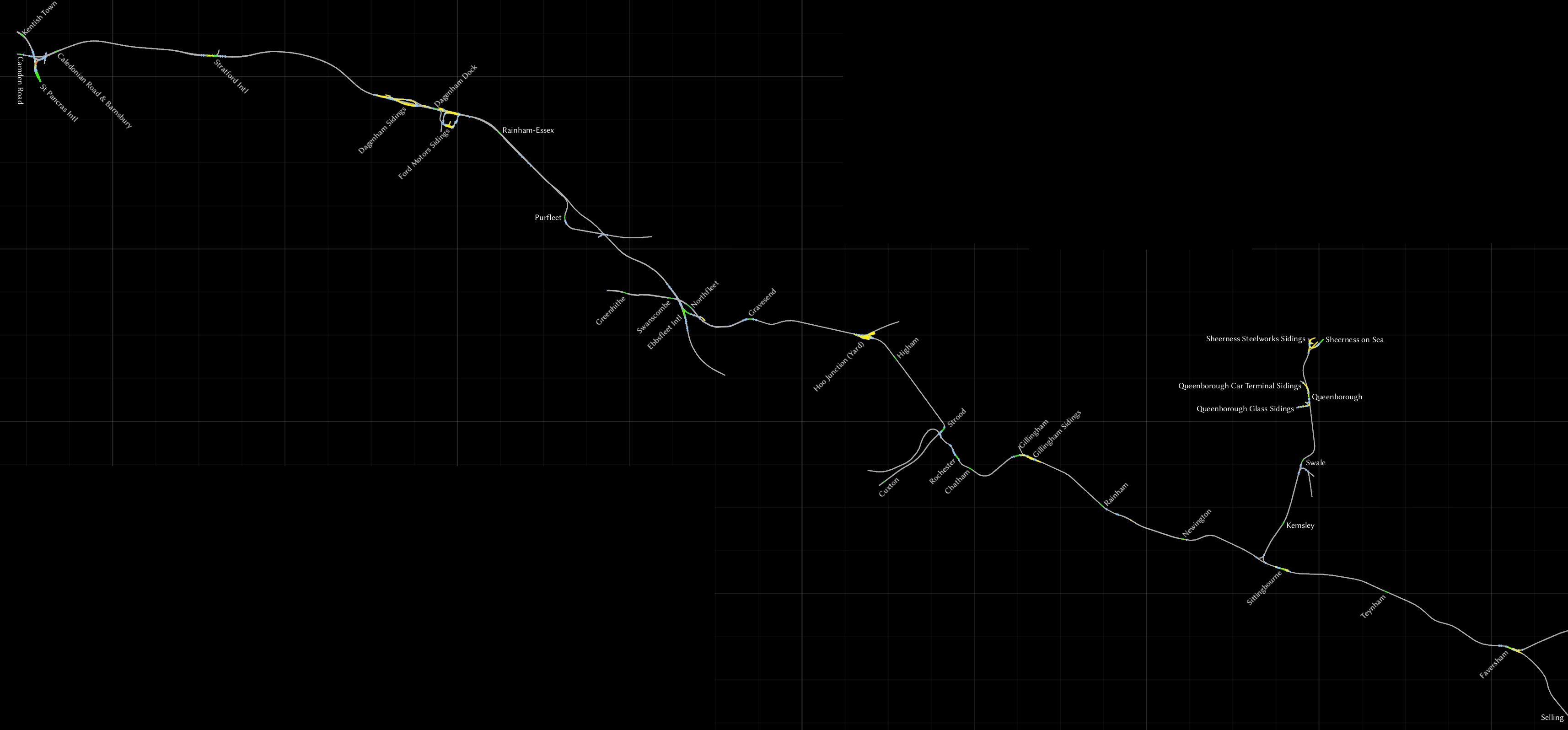
Stations near St. Pancras are missing scenery such as platforms and are not intended to have trains running on them. The London to Bedford route allows you to travel from St. Pancras northward via Kentish Town.
At Dagenham Sidings another such a decorative section of track starts, where HS1 comes above ground again. There are gantries, but no overhead wires on them. The track, which began abruptly at Dagenham, ends shortly after Purfleet. HS1 continues east.
At Ebbsfleet HS1 stops being a high speed line and joins the regular railway network again. Ignore Greenhithe, it is without scenery, but eastward from that everything’s fine.
At Hoo Junction, there’s a little wooden platform for each track. Regular services don’t stop here.
From Strood the line branches off to Cuxton, but that station has no scenery.
Near Sittingbourne you can head north onto the Sheerness Branch, heading onto the Isle of Sheppey. Swale is an odd station, in the middle of nowhere with no facilities. Trains do stop here, although there have been plans to close the station, or have a token service stop there just once a week.
Selling has no scenery, for all intents and purposes the line ends at Faversham.
South London Network
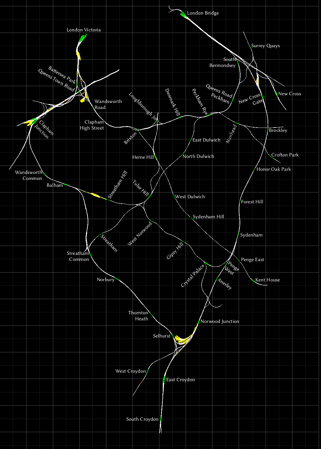
I’ve only been to London twice, but I never got to ride this route or its trains. I did get to ride the tube and DLR though. It’s a very pretty city and I recommend you visit it if you have the chance.
South London to Brighton
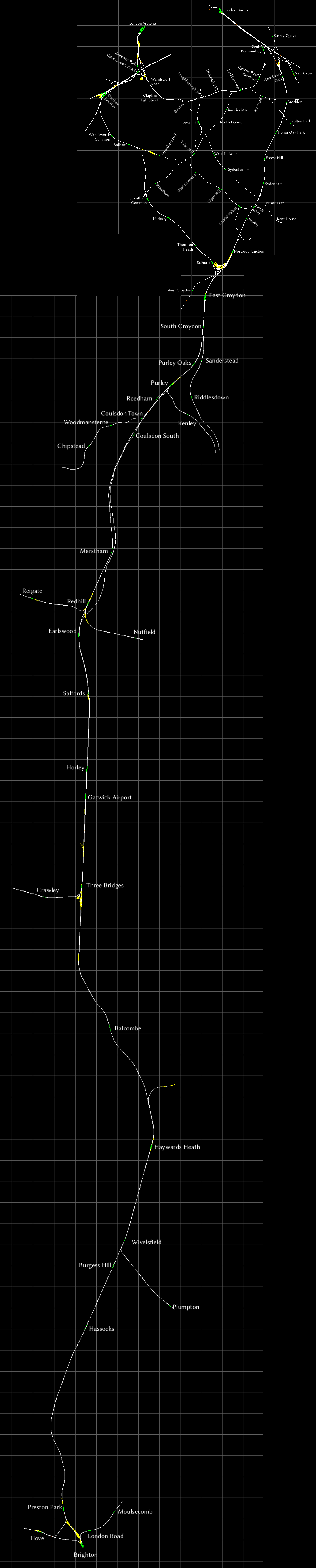
I’ve managed to merge the maps, the result isn’t perfect but better than I expected, and perfectly useable.
Weardale and Teesdale Network
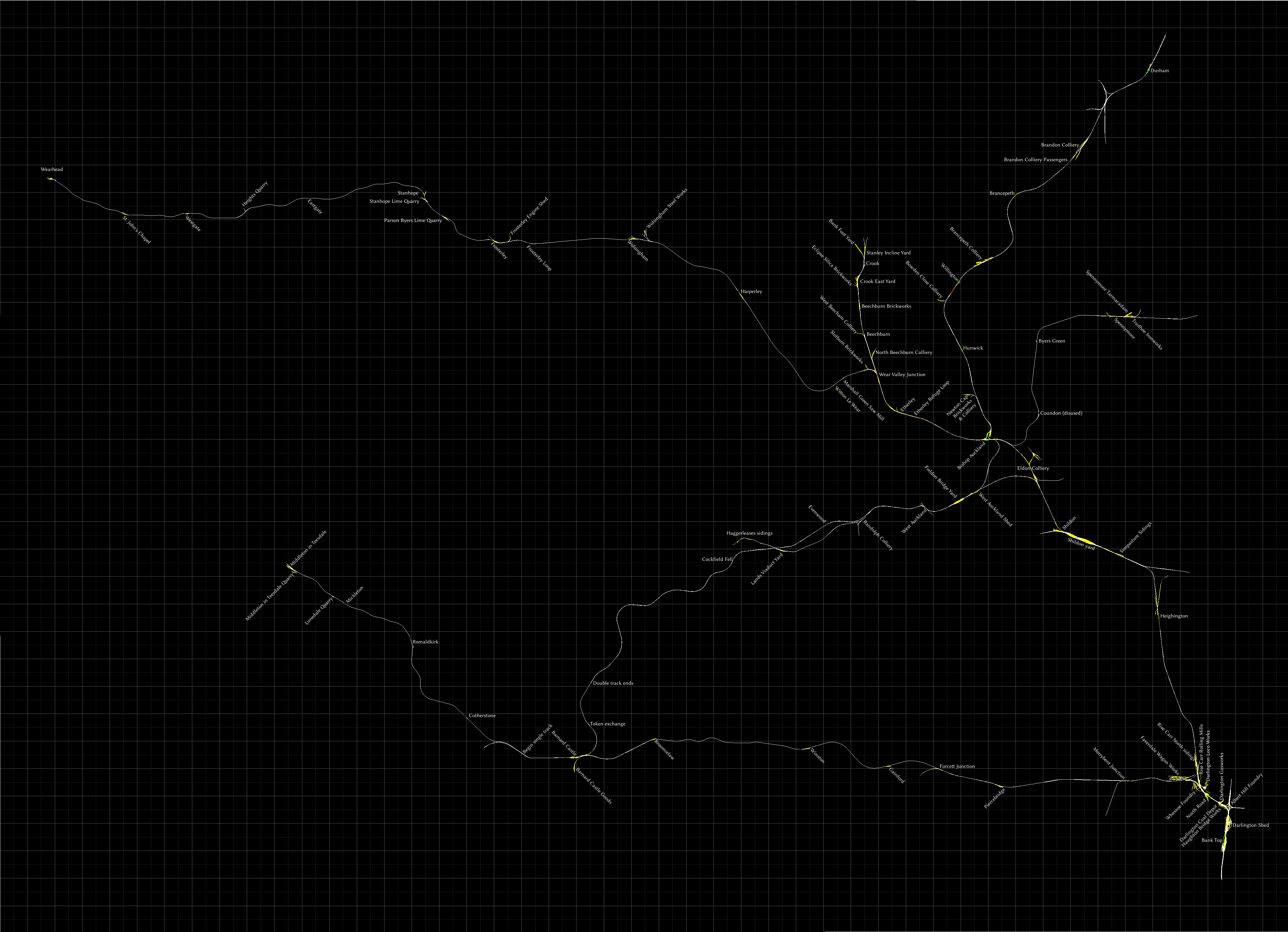
In my mind, this route is the stereotypical English rural landscape, with rolling hills and stone walls to separate fields. Just like on Postman Pat.
Sidings and yards can be identifeid by having those words in their names, or having the name of an industry in the names.
The area around Darlington is rather intricate, I’ve tried my best but space is a bit limited to put all the labels in.
- I named “Brandon Colliery Passengers” so because they appear to be passenger platforms next ot the industrial yard of the same name.
- I think Coundon station is disused. I marked it thus, because of the lack of platforms. It is just a passing loop with a name.
If I’ve made some mistakes here, let me know.
- Between Wear Valley Junction and Wearhead is single track with passing loops at every station.
- Bishop Auckland to Spennymoor is single track with passing loops.
- Between “Double track ends”, found south of West Auckland, and the point marked “Token exchange” it’s single track.
- Betwee Barnard Castle and Middleton in Teesdale is single track without any passing loops. The single track section begins west of Bardnard Castle, at a place I marked “Begin single track”.
- Broomielaw to Forcett Junction is single track, with a passing loop at Winston.
There’s a few places you may find useful to know if you’re running a steam locomotive.
Coal can be refueled at Darlington Shed, Middleton in Teesdale and Wearhead.
Water can be refilled at Barnard Castle, Bishop Auckland, Crook, Darlington Shed (North of Bank Top), Darlington South Turntable, Haggerleases, Middleton in Teesdale, Spennymoor and Wearhead.
There’s also a diesel fueling point at Darlington (North of Bank Top station)
There are turntables at Wearhead, Crook, Durham, Bank Top (2 of them, north and south of the station). There’s a bit of circular track at Whessoe Foundry that you can use to turn a locomotive too, of course. And there are plenty of triangular pieces of track you can use for turning, such as Bishop Auckland station.
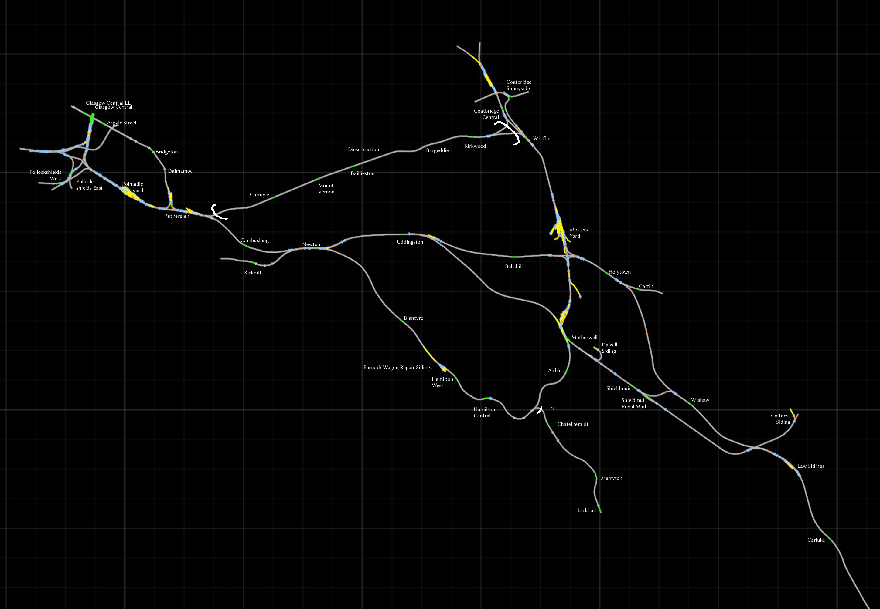
West Coast Mainline North
An older route that has it all. Yards for freight, long stretches for high-speed running and an elaborate network of commuter lines around Glasgow. The northern part of this route is a lot more complex than the southern part, so I’ve split the map in two. I’ve drawn some ugly white brackets to indicate which parts are not electrified.
For a unique experience not included with the default scenarios, take an EMU or DMU from Hamilton Central to Larkhall. Another curious bit of route is from Rutherglen to Glasgow Central LL.
If you want to travel further, starting from Carlisle, the WCML Over Shap, Settle-Carlisle and Western Lines of Scotland routes are worth checking out.
The Kirkwood-Carmyle section is double track but not electrified.
Chatelherault to Larkhall is single track (1t) but is still electrified.

Western Lines of Scotland

The track between Carlisle and Dumfries still exists today, and is represented on the WCML Over Shap route. It’s neat to compare the two and see what has, and hasn’t changed over the years.
I’m not a fan of the track texture on this route, but that’s easily fixed by installing the Trainworks.eu DBTracks update[trainworks.eu]. It comes with the familiar Black 5 steam locomotive in various liveries, but its physics have been updated slightly. There are steam servicing locations all over the route.
The manual comes with a bunch of maps and diagrams, as there are countless industry sidings that you can work with. But I didn’t see a full map of all passenger stations, so that’s what I’ve made here.
The route is double tracked between Carlisle and Castle Douglas. Everything else, including the line to Kirkcudbright, is single track. Nearly all passenger stations have double tracks where trains can pass each other. Some exceptions to be mindful of:
- Parton is single track
- Bridge of Dee is single track
- The track between Castle Kennedy and Dunragit is double tracked
Berlin – Wittenberg

The version sold on Steam is out of date and must be patched manually! Get the 1.26 patch directly from the creator[www.virtualtracks.net]. This patch adds Quick Drive and LZB. See the full list of changes[bahnjan.blogspot.nl] in German.
In the north is Berlin Hauptbahnhof. As the track heads south, the S-bahn joins it and runs parallel to it. The S-bahn is like a metro, using a third rail for power. S-bahn platforms and stops begin with an “S”. No scenario uses these tracks, but you can make your own. You can get an appropriate S-bahn EMU for free[rail-sim.de].
North of Grossbeeren station is the Güterbahnhof, a goods station.
Branching off towards the east is the line to Berlin Brandenburg International Airport. This airport was supposed to open in 2010, but as of today it’s still under construction. On the middle of the line is an area called Diedersdorf, consisting of four tracks. This appears to be a small yard, but you probably want to keep the middle two tracks empty so traffic isn’t blocked.
Continuing south towards Ludwigsfelde, there are a bunch of sidings and small yards to service the local industry
East of the track between Luckenwalde and Jüterbog you can see the remains of an old army base, built during the 1930’s and later used and expanded by the Soviets. It is the site of the Forst Zinna disaster, where a train struck a tank in 1988, considered one of the worst railway accidents in the GDR (East Germany).
If you like to run steam locomotives, Jüterbog yard has a turntable you may find useful.
At the southern end of the line is Wittenberg, which officially is called “Lutherstadt Wittenberg”, referring to the fact Martin Luther lived and worked there.
Northeast of Wittenberg is a yard with facilities to service steam locomotives, including a turntable.
Playing around with the journey planner on [link], it looks like regular RegionalExpress services stop everywhere except at Woltersdorf and Klebitz. From what I can tell, those stations are no longer in use.
Im Köblitzer Bergland V3 Reloaded / Koeblizter Mountain Route

It got a huge update in December 2019 and there were no maps of this version available online, so I made one.
This route is the most recent version currently available, and it has a long history: It started as the freeware Altenburg to Wildau[rail-sim.de] route. Every new release added more content, and also made some changes to represent the route in a different era.
You can have the different releases installed side by side in Train Simulator without problems. E.g. I have the original freeware Altenburg to Wildau installed alongside this V3 version. They show up as different routes so I can choose which one I want to drive.
About this map:
- Freight tracks have been marked Gbf (Güterbahnhof) or Rbf (Rangierbahnhof).
- The section between Köblitz West and Hosvenn is single tracked.
- The section between Wildau and Hosvenn is not electrified.
- The section between Köbler Wald and Rinckenstadt is single track and not electrified. It’s supposed to be a museum railway which has its own platform at Köbler Wald.
- There are no intermediate stations on the Schnellfahrstrecke / High Speed Line between Altenburg and Bad Rinckenburg.
- The former railway between St. Rudolf and Rinckenstadt is now a bicycle path. It’s not shown on this map, but it’s fully modeled so you can give it a look.
Be sure to check the manual for descriptions of all the locations that this route has to offer.
Köln – Düsseldorf
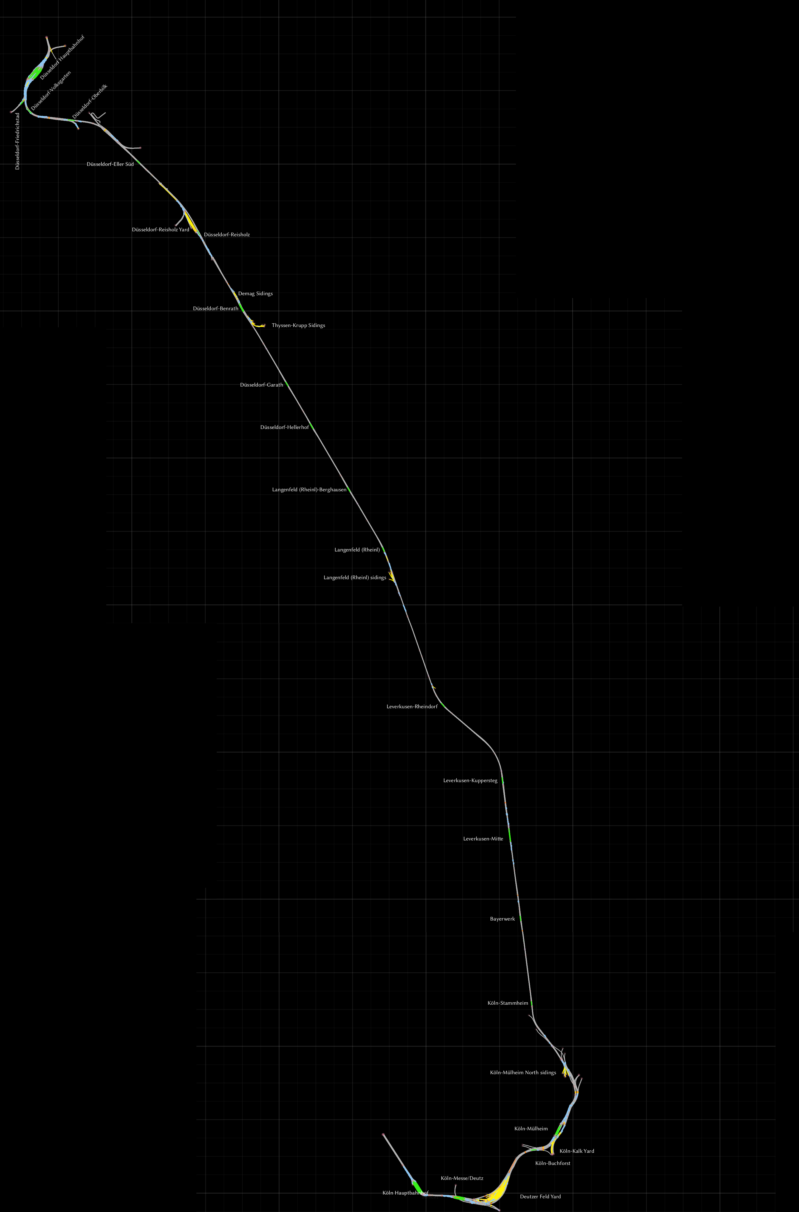
The approach to Köln is wonderful, passing over the Hohenzollern Bridge, heading straight towards the iconic cathedral. It’s a rail bridge, but pedestrians can use the pathways on both sides of it too.
There are plenty of stations to run commuter services on, and there’s a big yard on either end of the route for doing freight runs.
Don’t forget to check the manuals folder for the file diagram_Deutzerfeld.pdf, which is a very detailed map of the Deutzer Feld yard.
The tight curve of track slightly to the east of Düsseldorf-Oberbilk is for the city’s tram system, and is not hooked up to anything.
Konstanz – Villingen
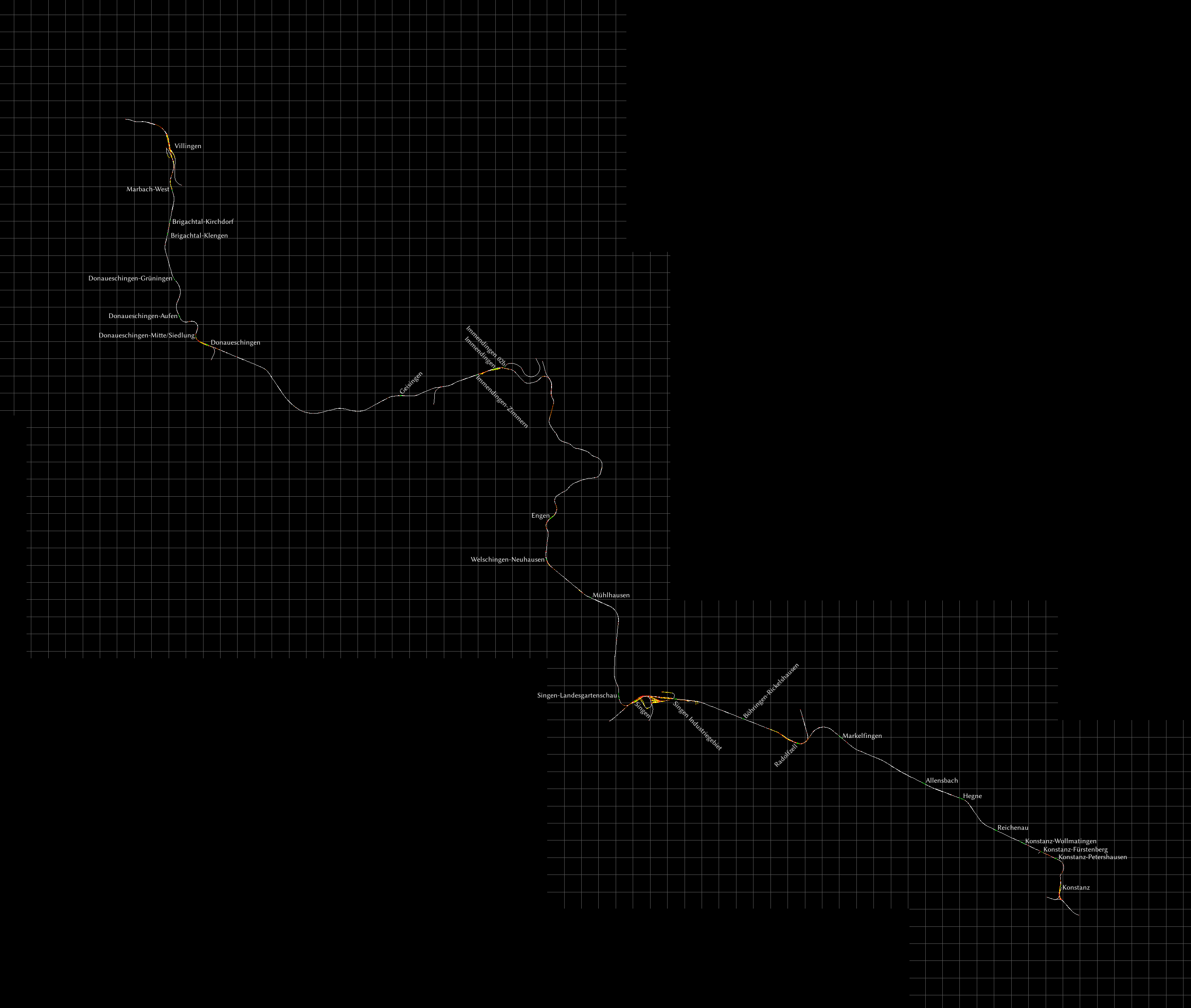
I’m a big fan of the entire area around Konstanz.
Get it from most third party sellers or directly on Steam. The Steam version has changed or removed a few brand names, but is otherwise the same and scenarios should be compatible.
There is also an expansion for this route called Hausach-Konstanz, but since I don’t own it I haven’t added it to the map.
Mannheim – Karlsruhe
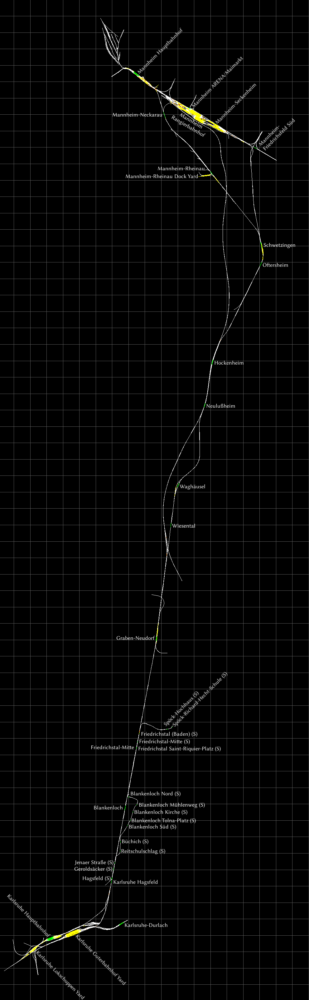
Some stations are marked (S) for Stadtbahn. These are light-rail stations. They don’t appear to be signalled and you can’t take a train to these stations via Quick Drive, so you’ll have to create your own scenarios for them. There are loops for turning at Spöck and Blankenloch Nord.
The Karlsruhe Stadtbahn vehicles can do a nifty trick where they switch from street running trams to full-fledged railway vehicles, which involes switching safety systems and line voltages. However that doesn’t happen on this route.
München – Augsburg

Like with München to Garmisch-Partenkirchen, I’ve used the German spelling of every name.
The München to Lochhausen section is the same as on the München to Garmisch-Partenkirchen route, so you can use the detailed enlarged map of the München area to get a good look at the yards, if you’d like.
Yards are only found near München and Augsburg. There’s an unnamed yard at Augsburg without any waypoints, so if you want to shunt there, you’ll have to use Free Roam or create your own markers for a scenario.
I didn’t like how the sound barrier walls were blocking the view of the scenery, so I created an edited version of this route where these walls have been removed. You can get it on the workshop.
München – Garmisch-Partenkirchen
My favourite German map. You can drive a train from a busy urban setting down into the quiet mountains. I’m a Dutchman, I’m easily impressed by a landscape that’s not flat. I like to take the BR420 down this route, or one of my Dutch trainsets.
For the sake of legibility, I’ve split this map in two. I’ve included all the yards, they are only found in the northern part of the route around München.
I’ve also fixed any spelling errors and used the German spelling of every name, so Munich is now spelled München, Loccham is now Lochham. I’ve named München’s main station “München Hauptbahnhof”.
Some of the stations are only for use by the S-Bahn local rapid transit services. If you’d like to stop at these stations, consider your starting platform carefully. München Tief Gleis 1 is the best place to start, as it’s the only platform from which you can get to Hackerbrücke.

The real-world line S6 starts in the east, on a station not on this route, and goes via München Tief up to Tutzing.
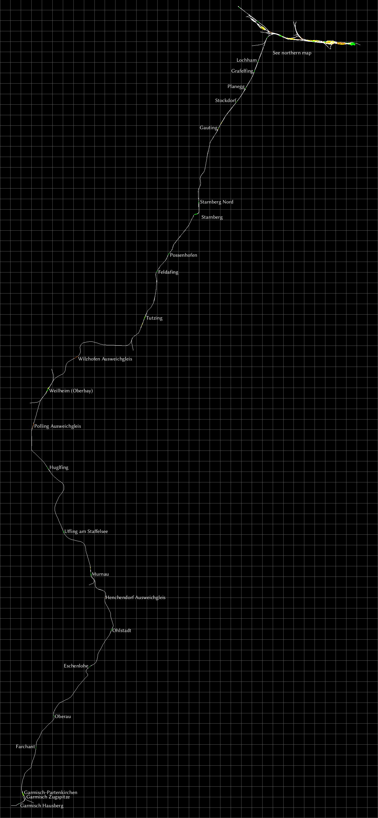
From Gauting further south, the line is double track up to Tutzing. After Tutzing it’s single track with some areas where you can overtake other trains. These areas are at all stations, but there are also a few without a station, labeled “Ausweichgleis”.
Murnau’s double track section extends for quite a bit southwards. but goes back to single track at the area marked Henchendorf Ausweichgleis. There’s a Nord and Sud waypoint there, so you pick the right track, depending on your direction of travel, north or south.
Around Garmisch-Partenkirchen there are two curious stations that are not hooked up to the rest of the route, Garmisch Hausberg and Garmisch Zugspitze. These are for the narrow-guage Zugspitzbahn that departs from here and heads up Germany’s tallest mountain, the Zugspitze.
I used this S-bahn diagram[commons.wikimedia.org] to find out about the routes.
Projekt Freiberg
A freeware route set in East-Germany before the fall of the iron curtain, with appropriate signs and signals. The main double track east-west route is electrified. At Freiberg there are lots of diesel branchlines available for goods and passengers.
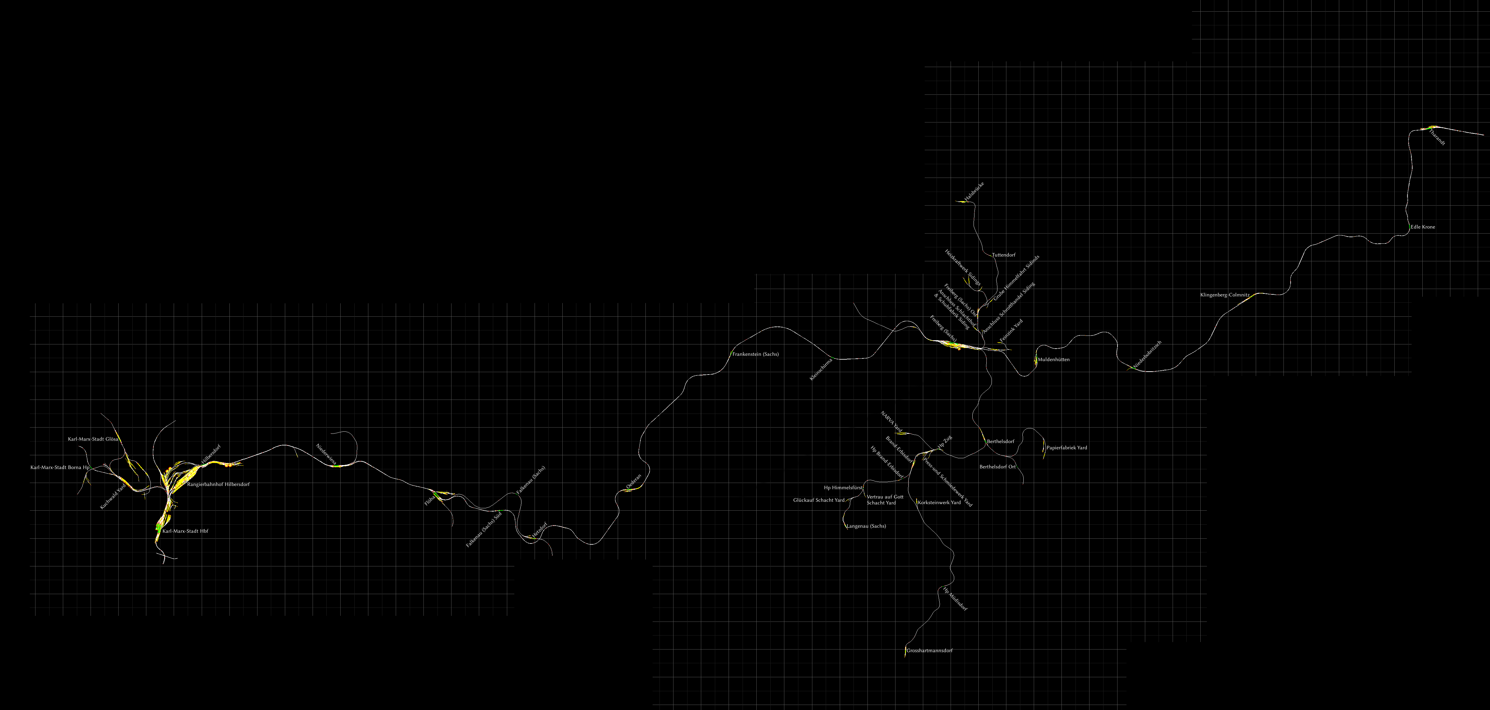
You can download the route from [link]. English language manual is included in the zip. I recommend grabbing the optional Quick Drive scenarios[rail-sim.de].
Ruhr-Sieg Line (Hagen-Siegen)

This one took a lot more effort than I thought, there are many sidings. I hope I didn’t miss any. A great route for freight fans, as there are lots of places to move goods in between.
Curiously, some smaller yards are still called “Siding”, like at Finnentrop, so I’ve duplicated that. I’ve also indicated a few loading points.
At each end of the route there’s a proper big yard, at Hagen and Kreuztal respectively.
At Siegen there’s a roundhouse with a turntable.
If you understand a bit of German, it’s totally worth downloading the v3.0 mod[rail-sim.de], which adds superelevation to the track, along with a whole bunch of smaller improvements. And you get a small branch line from Letmathe to Iserlohn.
S25 Through the Heart of Berlin / Mitten durch Berlin
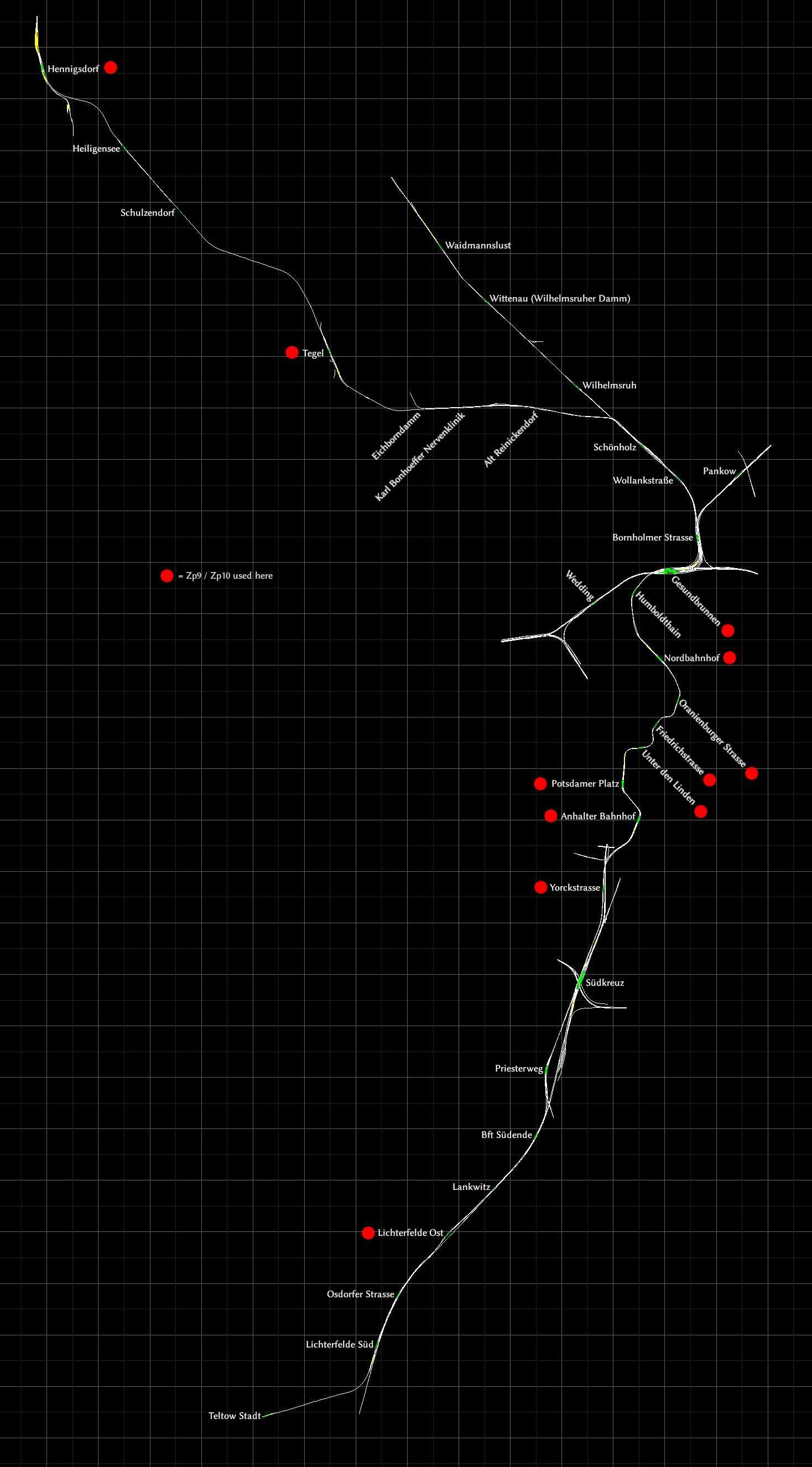
This route has taken those S-Bahn tracks and expanded further north into a full route.
There following sections are single tracked:
- Between Teltow and Lichterfelde Süd.
- Between Lichterfelde Ost and Südende. The intermediate station of Lankwitz has only one track, and no passing loop.
- Between Schönholz and Hennigsdorf. Passing loops are:
- Between Alt Reinickendorf and Karl Bonhoeffer Nervenklinik.
- At Tegel
- At Heiligensee
The stations from Anhalter Bahnhof to Nordbahnhof are in a very twisty tunnel.
The stations marked with a red dot have Zp9 and Zp10 signals available for the departure sequence.
Seebergbahn

The Seebergbahn is a short fictional route set in a scenic mountain area. It is actually based on a bit of the Lötschbergbahn, which is in Switzerland, going from Interlaken (Almsfeld) via Spiez (Seeberg) to Blausee-Mitholz (Dissen).
One of the interesting features of this route is that any train traveling via Seeberg has to reverse there to continue the trip.
This route came with the game when it was still called Railworks. It is no longer for sale. In fact, even if you owned this route in the past, you will find it is gone when you install Train Simulator on a new system.
However you can now grab it off the Workshop for free, and you’ll probably be able to run this even if you’ve never owned it, provided you own the “Classic European Assets”. You probably do. Don’t forget to check out the other two free routes on that RS MattP’s Workshop.
Cajon Pass

“Cajon” is Spanish, so it’s pronounced “Ca-hone”. Do not confuse with Cajun, which is from Louisiana, not California.
Map features all two stations, all yards and sidings and some waypoins, marked “WP”.
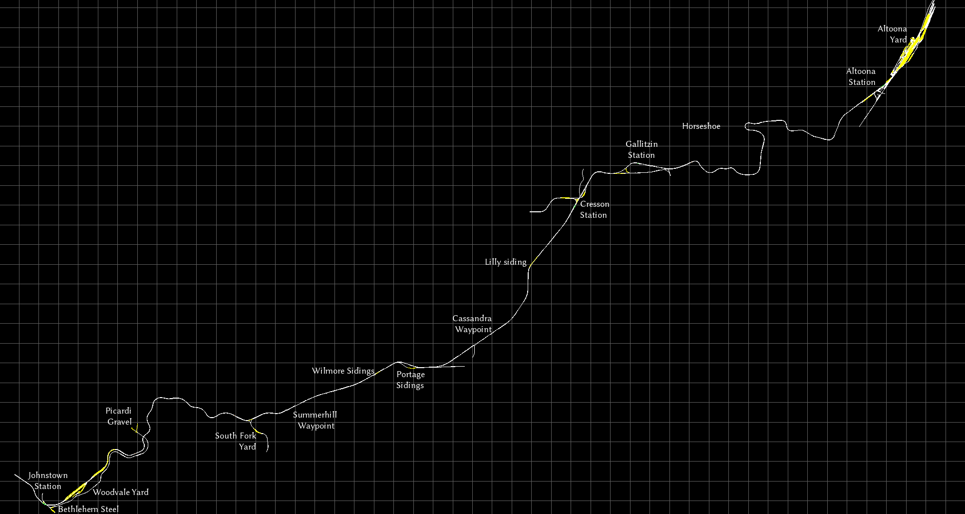
Horseshoe Curve
Majestic Falls

NEC: New York – New Haven
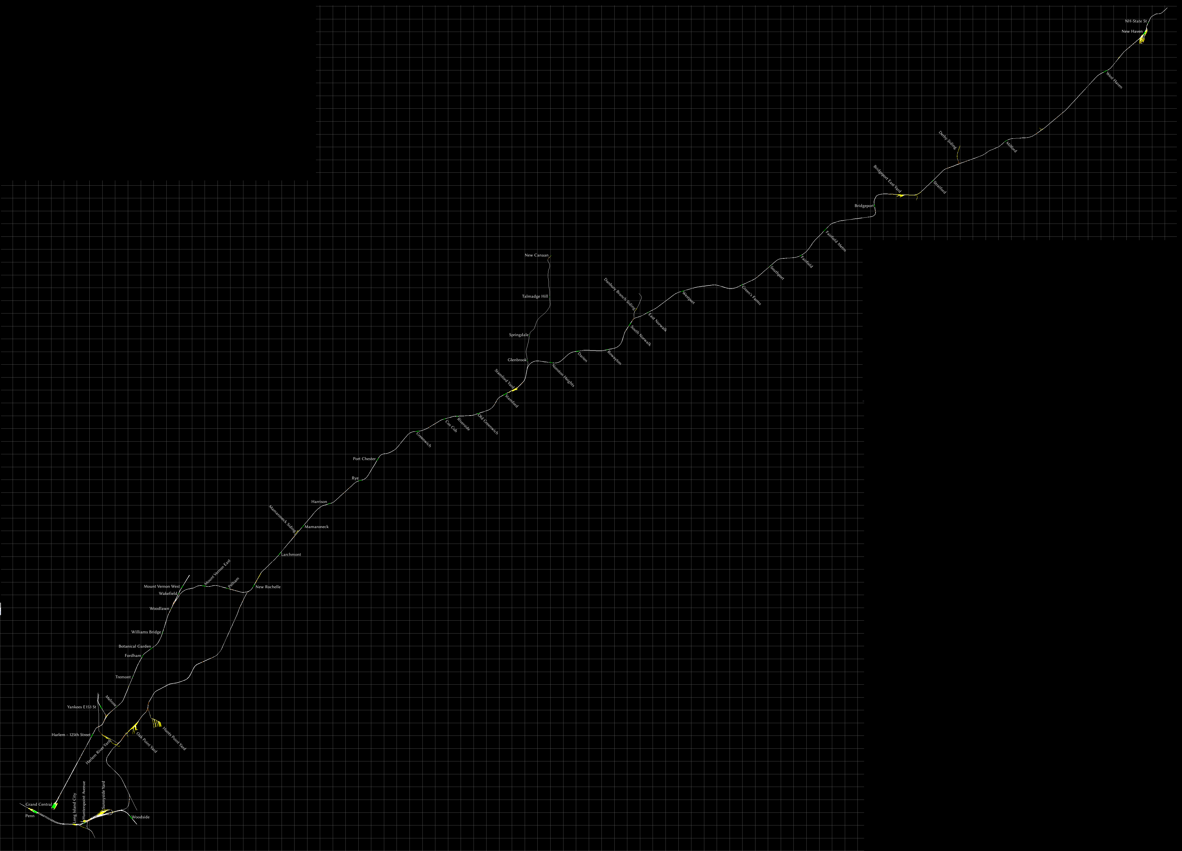
This is a commuter route, but it comes with an SD40-2 in CSX branding featuring in-cab signalling, which you can use to haul freight. Unfortunately, no scenarios for this train have been included. If you’d like to drive it, I highly recommend these three workshop scenarios by Elphaba, which require no additional DLC:
If you’d like a diagram instead of a map, I recommend this diagram of Metro North lines[upload.wikimedia.org].
Raquette Lake Railway

It takes about 45 minutes to drive from one end to the other. There are some very steep ascents and descents, heading east towards Raquette you’ll mostly be descending.
On the western end, there’s a wye for turning, and on the eastern end, there’s a balloon loop.
Soldier Summit

South of Springville Industrial sidings the double track splits into two single track lines, but from what I can tell the eastern one is for trains heading north (Track 1) and the western one for tracks heading south (Track 2). A few miles later both tracks are parallel to each other again.
The Summit yard is not generally used anymore, but it’s still there. There’s also a wye for turning engines. The yards at both outer ends of the route also features Y-shaped trackwork and partial loops that you can use to turn engines and maybe even entire trains.
“WP” indicates waypoints, “Loop” is a passing loop where trains can overtake each other. Loops may not always be accessible from each direction. “X-over” indicates a point where trains can change tracks, but again, this isn’t always possible in each direction.
Tucker and Ghost Town are referenced in the route diagram in the manual, but there are no waypoints or other track markings that refer to them. I’ve estimated their positions and put them on the map.
Stevens Pass

All four passenger stations are included, and every yard. I’ve also added most sidings and some waypoints, labeled “WP”. These waypoints are usually passing loops, you can find the details in the manual.
Official maps
Here is a list of routes for which official maps already exist, although the level of detail varies wildly. Most newer routes released by DTG include a basic map in the manual.
For routes you own, you can often find the manual by starting Train Simulator, selecting “Options”, then “Tools” and finally “View Manuals”.
If I could, I would put the maps right here in this guide, but Steam’s rules forbid this. I’m still allowed to provide a link to them though.
WARNING: Many of the links here have broken after DTG changed their website again. I’ll see if I can fix them.
- ECML London to Peterborough. A basic map is in the manual.
- Liverpool to Manchester: A basic map is in the manual[www.railsimulator.com].
- Portsmouth Direct Line (Woking-Portsmouth): No full map, but there’s a height diagram and lots of track diagrams complete with speed limits in the manual[www.railsimulator.com].
- Settle to Carlisle: No map, but a height diagram is in the manual[www.railsimulator.com]. All stations are on this diagram.
- WCML Over Shap: A somewhat minimal map (no yards) is in the manual[www.railsimulator.com].
- WCML Trent Valley: There’s a good map in the manual[www.thomsoninteractive.com].
- Western Lines of Scotland: Maps in the manual[www.train-simulator.com].
- West Highland Line South: Map and height diagram are in manual[www.train-simulator.com].
- Woodhead: Maps and quite extensive height diagrams are in the manual[www.railsimulator.com].
- Donner Pass: A basic map is in the manual[www.railsimulator.com].
- Marias Pass: A height diagram, yard diagrams and a rather bad, colour-coded map is in the manual[www.railsimulator.com]. Not sure if it’s of any use if you’re colourblind.
- Pacific Surfliner: A basic map is in the manual[www.railsimulator.com].
- Sherman Hill: Lots of maps and diagrams are in the manual[www.railsimulator.com]. I wish every route was as well documented as this.
- Cologne (Köln) to Koblenz: A basic map (no yards) is in the manual[www.railsimulator.com].
- Hamburg-Hanover: A basic map (no yards) is in the manual[www.railsimulator.com].
Other maps and diagrams
Here are some maps and route diagrams I’ve found on-line. Some of these integrate with Google maps so you can also see where they are in the world.
- Purno has created a whole bunch of diagrams on Steam Guides.
- Marleyman has put a few routes on Google Maps[www.railworks.marleyman.co.uk], and also offers route diagrams for download[www.railworks.marleyman.co.uk]. It’s a bit confusing, you need to use his on-line shop but it’s free and no payment data is requested. You will still need to register though.
- Pethu’s maps[cvk.pethu.se] – all set in the UK, and all using Google maps
On the German rail-sim.de forums I found a thread that has a map of all German routes[rail-sim.de] that are available for Train Simulator, including both free- and payware content. A bit old though.
You may also want to take a look at Open Railway Map[www.openrailwaymap.org], a crowdsourced site with maps of railways, current and former, all around the globe.
On the Sporenplan[www.sporenplan.nl] website you can find topological track diagrams of railways from various European countries, including Germany and the Netherlands.
Contributing: Tools and Style Information
If you’d like to contribute to the guide by creating some maps yourself, here are the tools I used, as well as some style information in case you’d like to make them look the same way.
To get an image of the route itself, I used to just take screenshots using the game’s built-in map feature. Most maps are made by stitching multiple screenshots stitched. More recently, I’ve also used the free third party rwinfo[www.10a.ch] tool, which I can stretch to fit multiple screens, meaning I have to take fewer screenshots.
I used the GIMP[www.gimp.org] to edit the maps. Click the name to download. It is free software. I use GIMP’s own XCF format so I have layers and can edit and move labels around when I please. I save the map as PNG before uploading to Steam. JPG is not suited for these kinds of images, as it makes the lines blurry.
You will need to click the button “Path from text”, after you’ve typed in your label. Then you can use the rotation tool (Shift+R) to rotate the text. Unfortunately, once you finish rotating, you can no longer edit the text, so throw the label away and make a new one if you made a typo.
The font used is Linux Biolinum[www.linuxlibertine.org] regular at size 18, hinting disabled, anti-aliasing enabled and colour set to pure white (#ffffff). Click the font’s name to download. Font nerds, this is the sans-serif variant of Linux Libertine, the font used in Wikipedia’s logo.
Have fun!
I hope you’ve found my maps useful. Like I said before, if I’ve made a mistake, please leave a message in the comments, and I’ll have a go at fixing it.
