Hidden and unmarked roads - USA - MIDWEST - updated 2026/02/20
This guide contains only Iowa, Kansas, Missouri, Nebraska. For other locations, please refer for the other guides: https://steamcommunity.com/sharedfiles/filedetails/?id=3629081644 https://steamcommunity.com/sharedfiles/filedetails/?id=2129261150 https://steamcommunity.com/sharedfiles/filedetails/?id=618897575
This is a list of all drivable roads not marked on the map and accessible without any mod or console commands, and the walkthrough on how to reach them.
It assumes you have ALL map DLCs released until now. So those hidden roads near the border that are physically located on one state, but it depends on the other state to be accessible, are listed under the state it's located.
It isn't supposed to be a guide to EASTER EGGS, although in some cases the unmarked roads lead to them.
It isn't supposed to be a guide to complete 100% of ACHIEVEMENTS either, but some of the unmarked roads are related to some of them. In these cases, the walkthrough will be marked as spoiler and you must hover the pointer over the black mask to show picture and description, LIKE THIS.
NOTE: if the achievement is directly related to hidden roads (for example, "Can You Keep a Secret?" in Kansas), then it's not marked as spoiler. That's why you are here after all.
This guide is organized by STATES and then by CITIES alphabetically. When the unmarked road isn't located in a city, the closest one will be used as reference.
Each screenshot has a map, with the unmarked road written on GREEN or RED, and the same colors are used on arrows and notes on the screenshots.
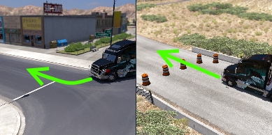 GREEN: the road doesn't have any UI roadblocks (glowing arrows or Xs where only AI drivers are allowed), invisible walls or hard objects blocking it, it's just not marked on map. Some times only easy-to-move objects (cones or signs, for example) are blocking it. You can go through it without problems - even when they have "no trucks allowed" signs. In some cases, these roads can be marked on map after discovered.
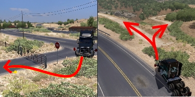 RED: the road's blocked by UI roadblocks or hard objects, or simply aren't connected to the playable area. That is, the ones the players weren't supposed to be - they're supposed to be scenery only. You must use breaches and devs' oversights to explore these areas. In most cases, these breaches are fixed after some time.
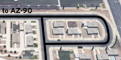 BLACK: the lines indicate the route player can drive after accessing the road. The text indicates points of reference, like landmarks, roads and cities - the same references listed on the walkthrough.
Each unmarked road can be on one or more of the following categories:
SCENERY: it's supposed to be eye-candy only, without any real use besides taking a cool screenshot in a different place. Of course, any of the other categories are implicitily scenery too.
SHORTCUT: it's an alternative route connecting two or more marked roads. Just note that, besides the name, it isn't always the shortest or the easiest route.
EASTER-EGG: it's a message or joke left by the devs, or even a pop culture reference. Notice that only easter eggs related to unmarked roads are listed here, you must check other guides to find other easter eggs.
ACHIEVEMENT: an achievement will be unlocked after hitting a certain spot of the unmarked road. The achievement name is written besides this category. Again, only the ones related to unmarked roads are listed here.
MARKABLE: it's an unmarked road that appears as a dotted path on map after discovered, so it can be easily found later. It's a feature added on version 1.44.
This is a list of all drivable roads not marked on the map and accessible without any mod or console commands, and the walkthrough on how to reach them.
It assumes you have ALL map DLCs released until now. So those hidden roads near the border that are physically located on one state, but it depends on the other state to be accessible, are listed under the state it's located.
It isn't supposed to be a guide to EASTER EGGS, although in some cases the unmarked roads lead to them.
It isn't supposed to be a guide to complete 100% of ACHIEVEMENTS either, but some of the unmarked roads are related to some of them. In these cases, the walkthrough will be marked as spoiler and you must hover the pointer over the black mask to show picture and description, LIKE THIS.
NOTE: if the achievement is directly related to hidden roads (for example, "Can You Keep a Secret?" in Kansas), then it's not marked as spoiler. That's why you are here after all.
This guide is organized by STATES and then by CITIES alphabetically. When the unmarked road isn't located in a city, the closest one will be used as reference.
Each screenshot has a map, with the unmarked road written on GREEN or RED, and the same colors are used on arrows and notes on the screenshots.
GREEN: the road doesn't have any UI roadblocks (glowing arrows or Xs where only AI drivers are allowed), invisible walls or hard objects blocking it, it's just not marked on map. Some times only easy-to-move objects (cones or signs, for example) are blocking it. You can go through it without problems - even when they have "no trucks allowed" signs. In some cases, these roads can be marked on map after discovered. RED: the road's blocked by UI roadblocks or hard objects, or simply aren't connected to the playable area. That is, the ones the players weren't supposed to be - they're supposed to be scenery only. You must use breaches and devs' oversights to explore these areas. In most cases, these breaches are fixed after some time. BLACK: the lines indicate the route player can drive after accessing the road. The text indicates points of reference, like landmarks, roads and cities - the same references listed on the walkthrough. Each unmarked road can be on one or more of the following categories:
SCENERY: it's supposed to be eye-candy only, without any real use besides taking a cool screenshot in a different place. Of course, any of the other categories are implicitily scenery too.
SHORTCUT: it's an alternative route connecting two or more marked roads. Just note that, besides the name, it isn't always the shortest or the easiest route.
EASTER-EGG: it's a message or joke left by the devs, or even a pop culture reference. Notice that only easter eggs related to unmarked roads are listed here, you must check other guides to find other easter eggs.
ACHIEVEMENT: an achievement will be unlocked after hitting a certain spot of the unmarked road. The achievement name is written besides this category. Again, only the ones related to unmarked roads are listed here.
MARKABLE: it's an unmarked road that appears as a dotted path on map after discovered, so it can be easily found later. It's a feature added on version 1.44.
18th DLC, announced
16th DLC, 2025 July 10
Council Bluffs
East 1 - Hidden Landmarks
Category: achievement (Madison County Bridge), markableDiscovery: Wide Kemo
Note: in order to unlock Madison County Bridge achievement, you need to cross the covered bridge that names it; please refer to this guide by Xeeran to find other achievements
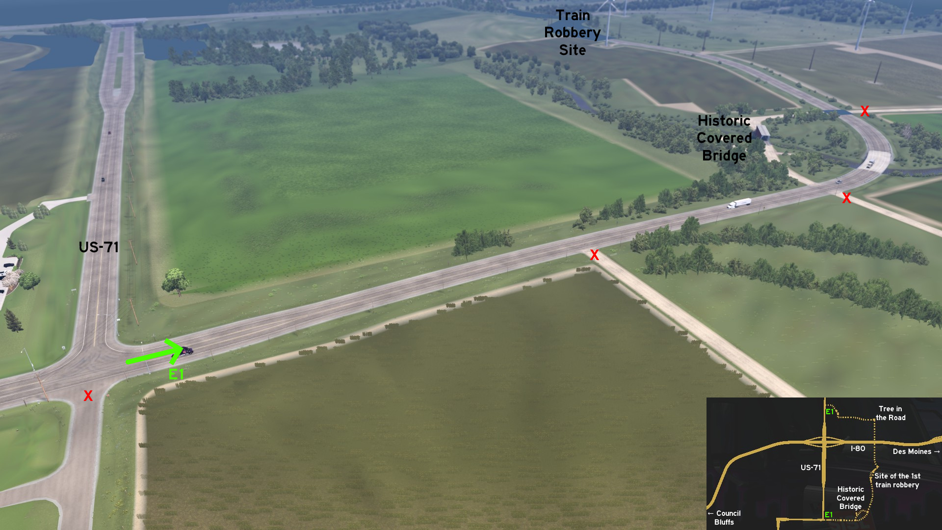 Leave east Council Bluffs through I-80 and halfway to Des Moines exit to US-71. Head south and then east again. You can cross one of Madison County covered bridges. Keep going north, and you'll see the site of the first train robbery, committed by Jesse James' gang. Drive over I-80 and you'll see the Tree in the Road before returning to US-71, some miles before Audubon and the World's Largest Bull.
 East 2 - No Rest For The 18-Wheelers
Category: scenery, markableDiscovery: Oni
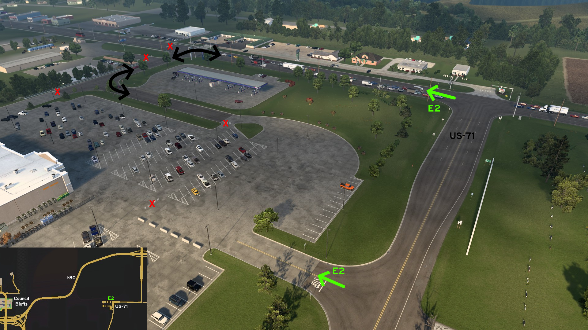 Leave east Council Bluffs through I-80 and exit to US-71 southbound. Turn right (west), and when you reach the first crossing, keep straight. Then turn left (south). You can't rest on this parking lot, but you can still use it as a detour.
Davenport
East 1 - Rocky Loop
Category: sceneryDiscovery: Oni
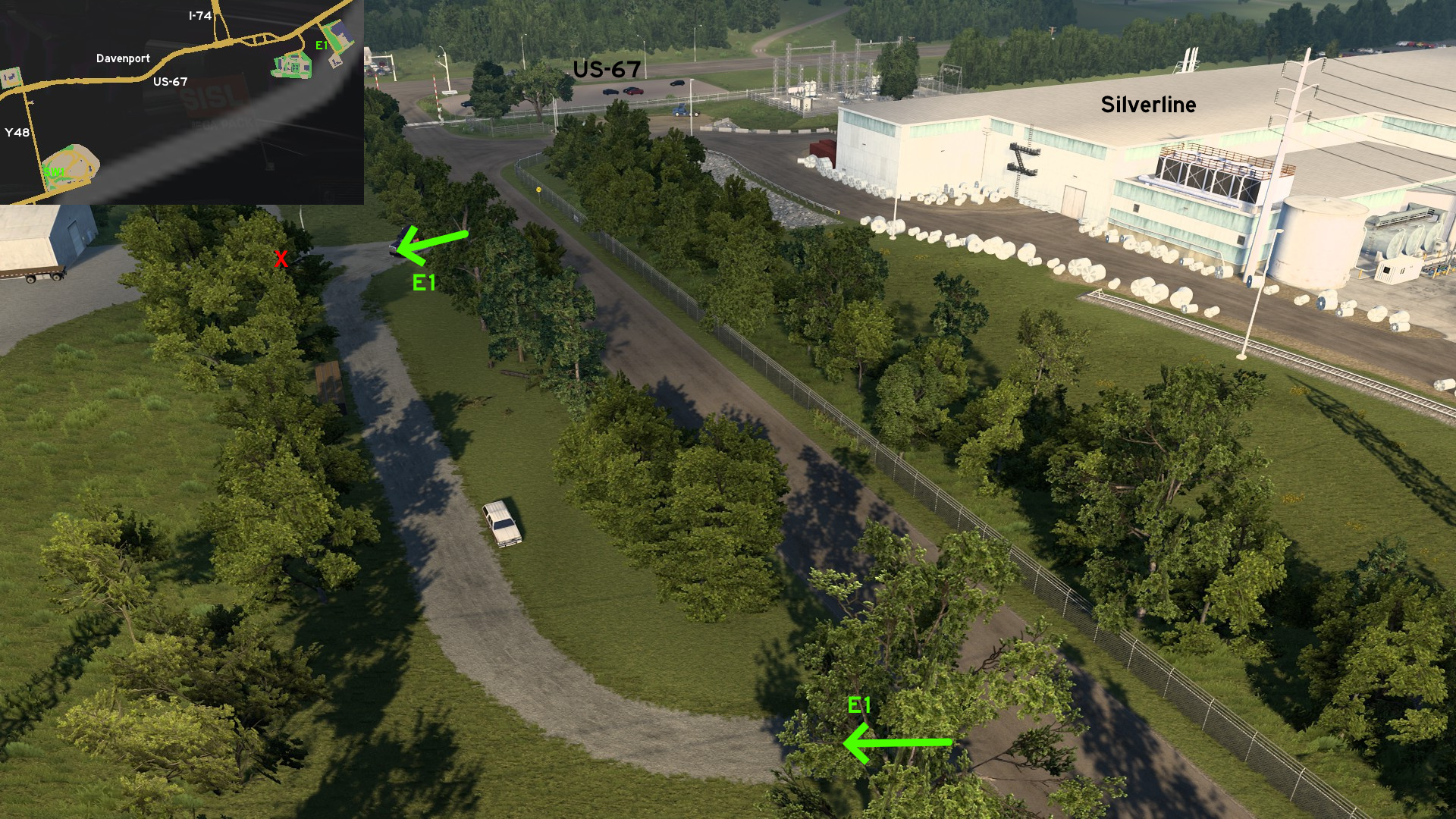 From Davenport, head to US-67, and then to the road to Silverline and Vortex. Right in front of Silverline depot, a gravel loop can be used for maneuvering.
Southwest 1 - Rocky Double Exit
Category: shortcutDiscovery: Applecorn
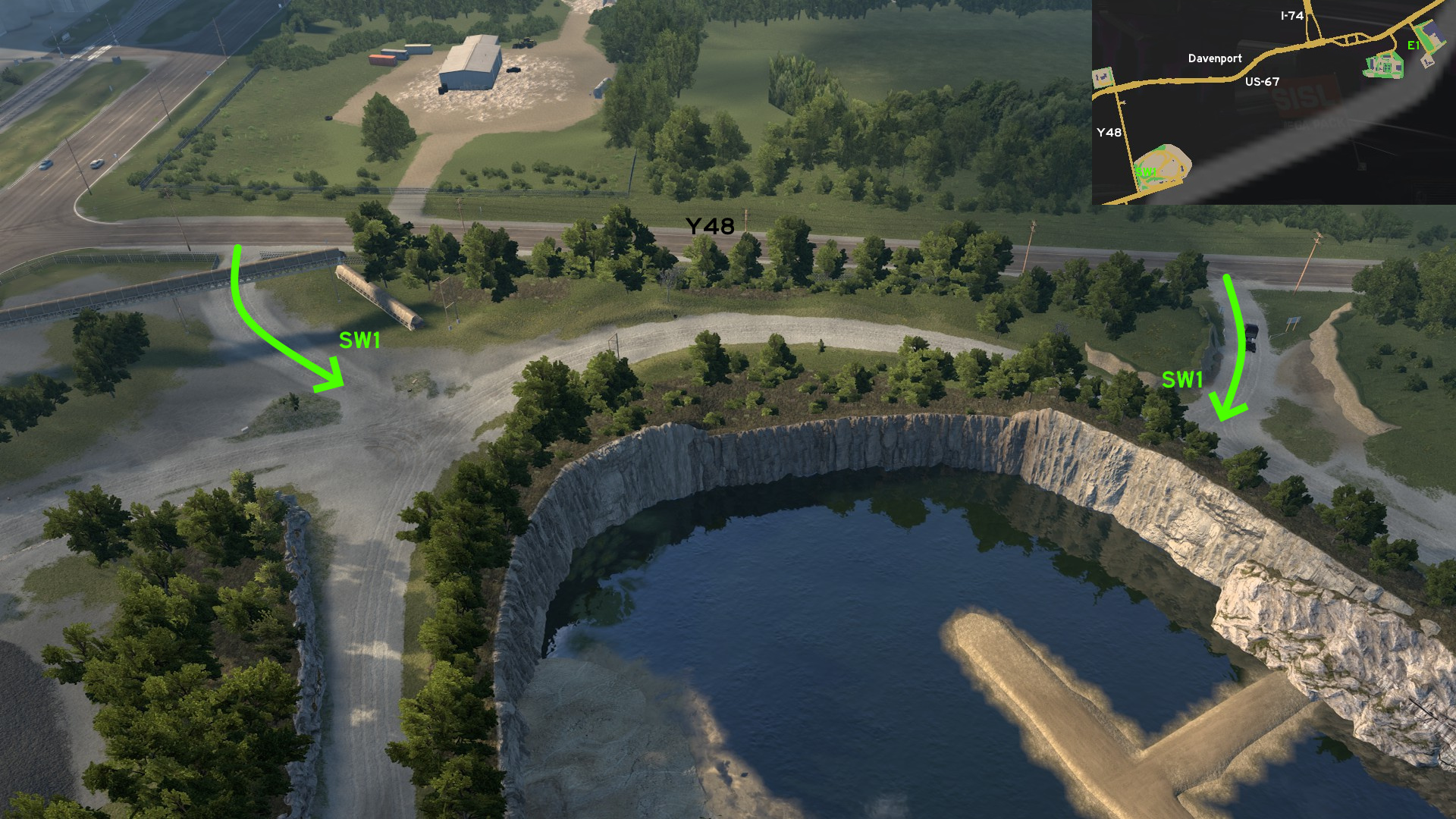 From Davenport, head to US-67, and then to Scott County Y48 route. You can access the big mining area from two exits directly from this route.
Dubuque
Northwest 1 - Steep Detour
Category: scenery, markableDiscovery: omni2226, Oni
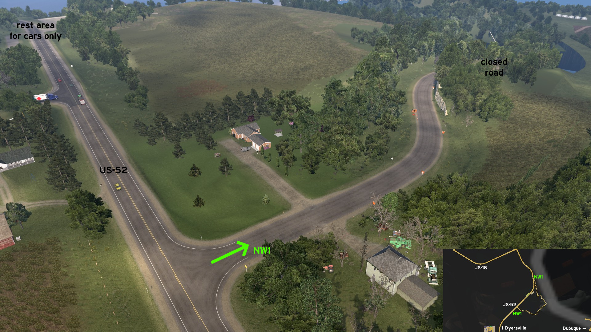 Leave west Dubuque through US-20 then exit north on US-52. A crossing north of the unmarked town of Dyersville leads east - on GPS, it's under US-52 shield. Road is closed, and detour goes into steep ramps. They end into a camping area, which continues along train tracks and a river. The route ends north of a rest area for cars only. Pulling a trailer isn't recommended here.
 West 1 - If You Build It, Truckers Will Come
Category: scenery, markableDiscovery: Wide Kemo
Note: the maze itself isn't markable (maybe for obvious reasons)
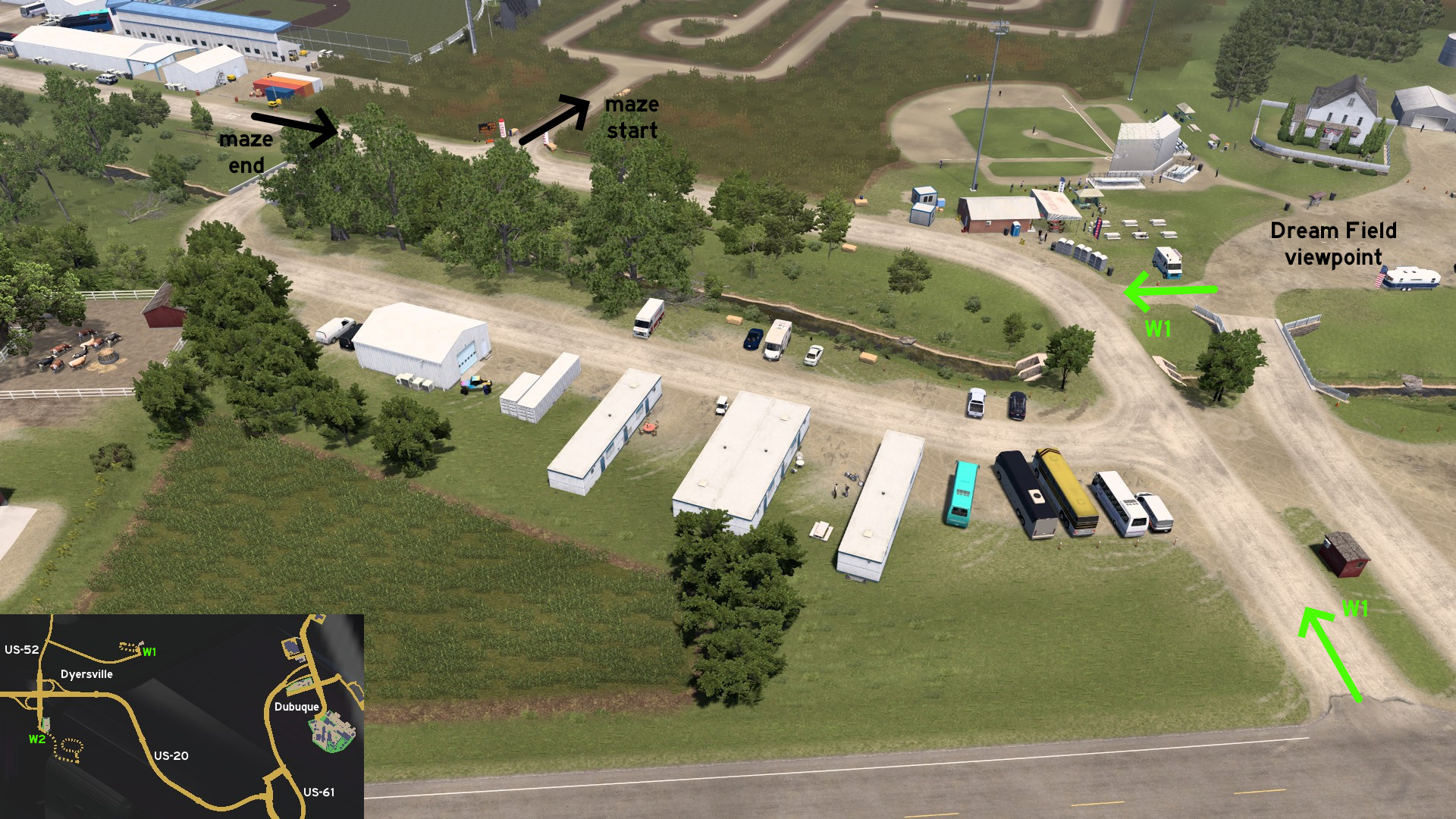 Leave west Dubuque through US-20 then exit on US-52 to the unmarked town of Dyersville. Head east to the location where Field of Dreams was filmed. West of the viewpoint, a loop leads to the start and the end of a maze made through the cornfields. It's recommended to not enter there while pulling a trailer.
West 2 - Race On 300
Category: scenery, markableDiscovery: Oni
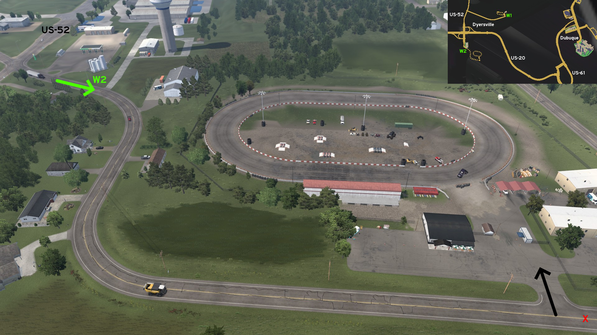 Leave west Dubuque through US-20 then exit south on US-52 to the unmarked town of Dyersville. Continue southeast from the fuel station. Before reaching the last curve, turn left (north). Now you can race on 300 Racetrack.
Fort Dodge
Northwest 1 - Different Business, Same Road
Category: shortcut, markableDiscovery: olm823249
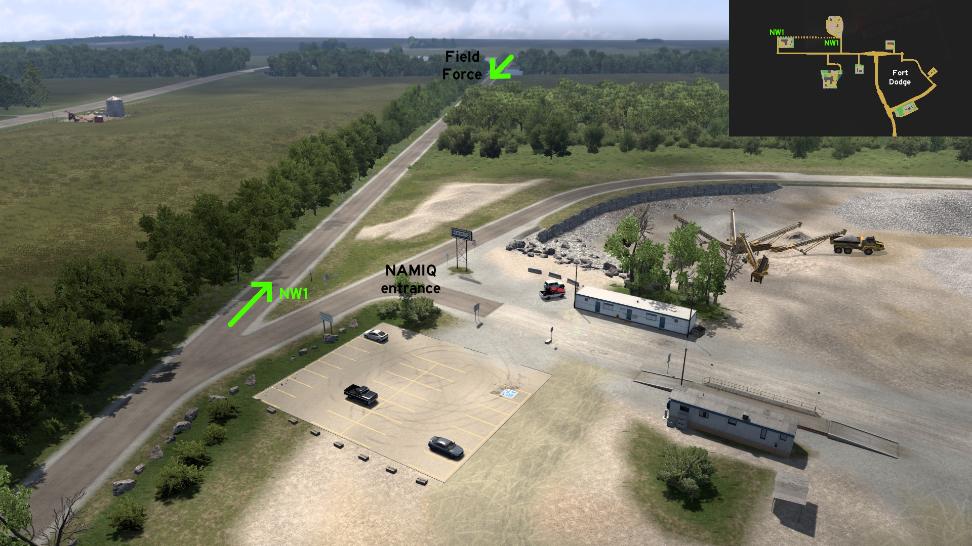 Go to NAMIQ northwest of Fort Dodge. Instead of turning right to the mine entrance, keep forward and you'll find an alternative route to Field Force depot. This road runs parallel to the marked route.
 Southwest 1 - Ride Like The Wind
Category: shortcut, markableDiscovery: olm823249
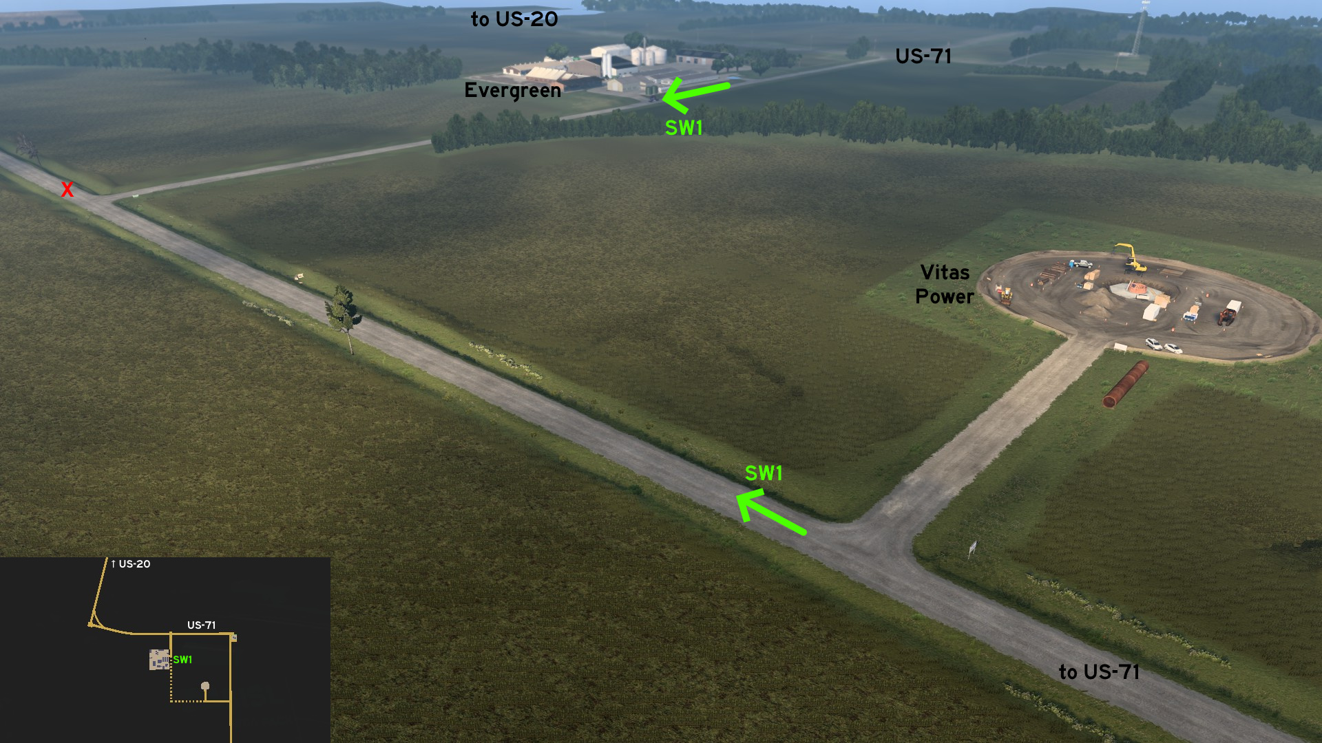 Leave Fort Dodge through US-20 westbound, and exit to US-71 southbound. Head to either Evergreen farm or Vitas Power construction site. A dusty road connects both, and you can use it to avoid the traffic from the junctions.
Iowa City
South 1 - Where No Trucker Has Gone Before
Category: easter-egg, markableDiscovery: olm823249, Oni
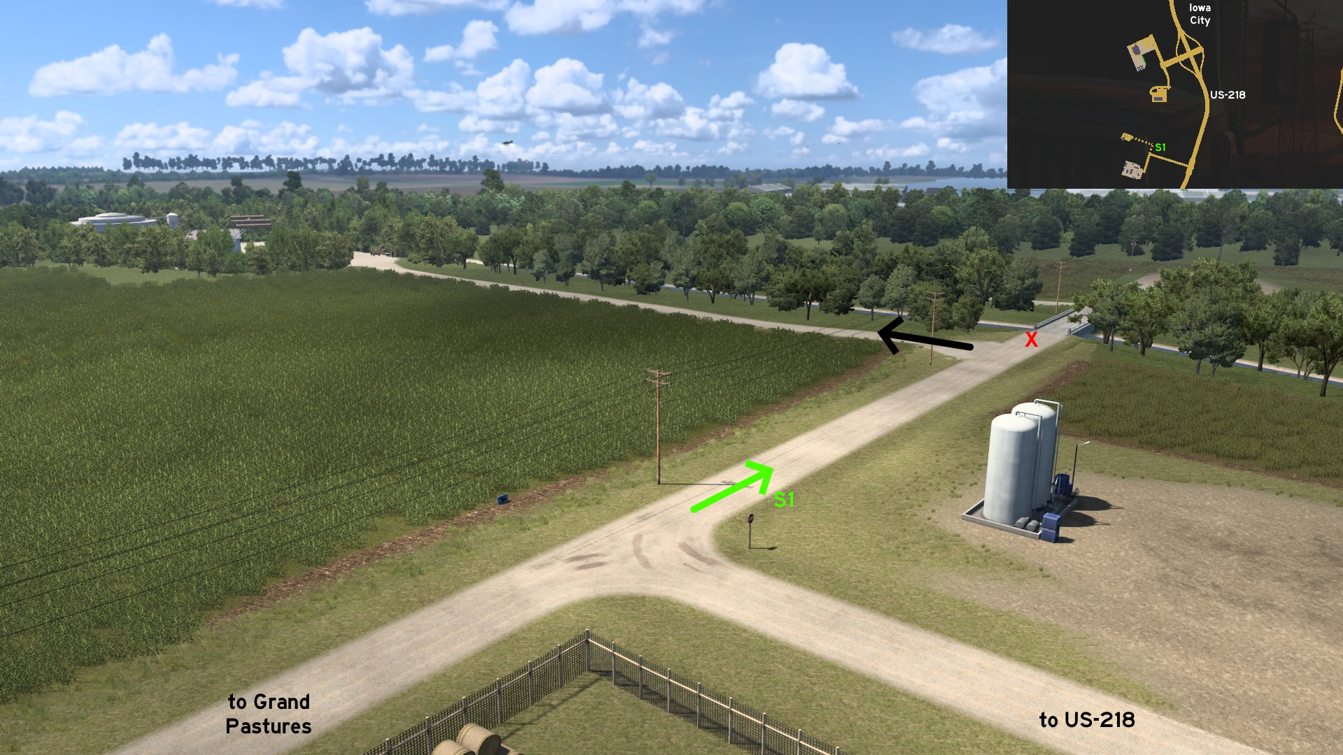 Leave south Iowa City through US-281 and head to Grand Pastures. Instead of going to delivery area, go the opposite direction, and turn left (west) before the bridge. You'll find a warehouse built like the Enterprise from Star Trek. Make sure to enter the warehouse to see the Borg Cube.
Ottumwa
East 1 - The Real American Gothic
Category: scenery, markableDiscovery: Wide Kemo
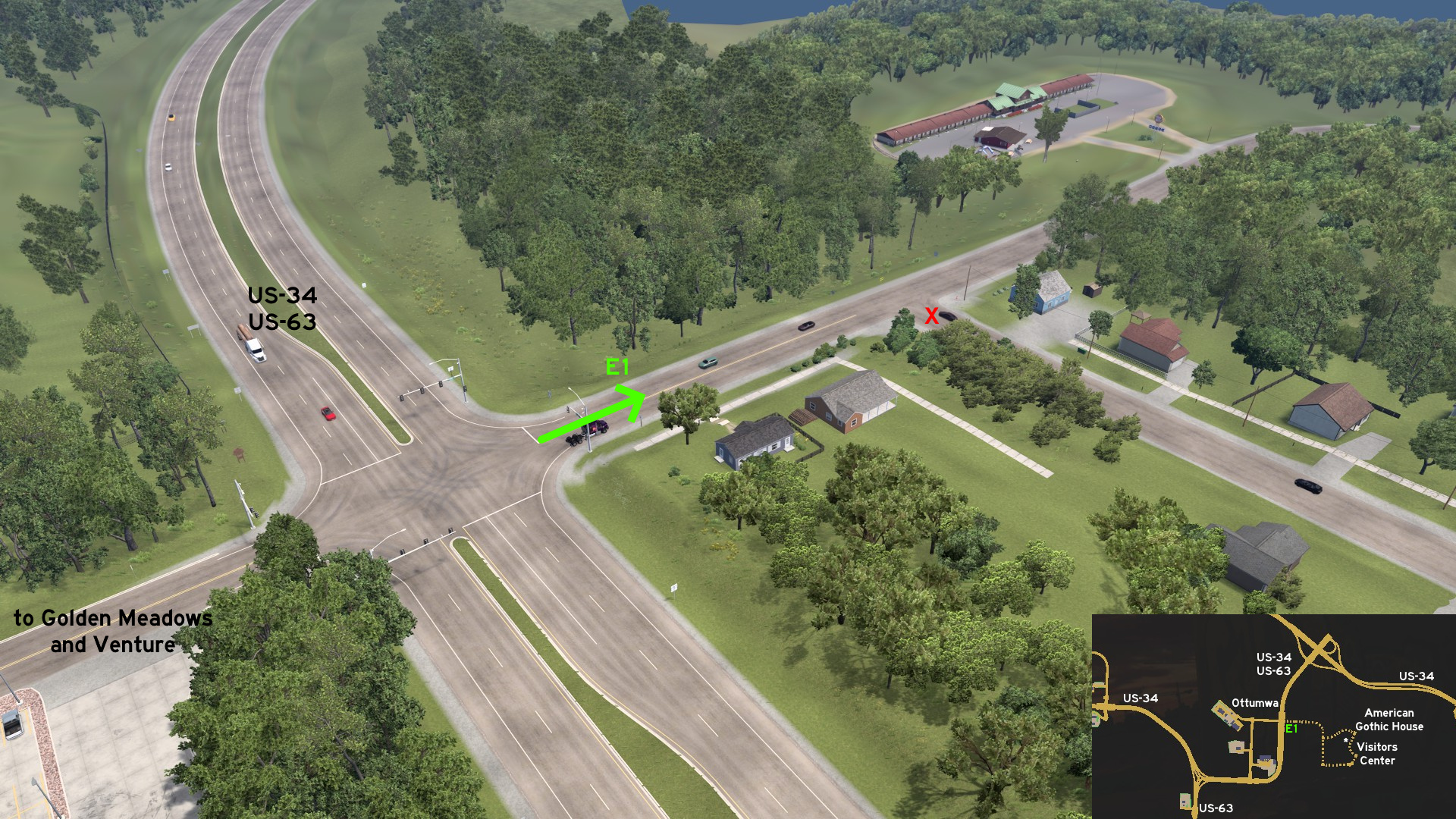 Go to the road that leads to Golden Meadows and Venture on Ottumwa, and head the opposite direction. Drive by a motel until you reach a loop around the unmarked town of Eldon. The house that inspired Grant Wood's painting, American Gothic, is on northeast corner of the loop. Some meters south from it, you'll reach the Visitors Center, where a replica of the farmer and his daughter from the painting wait for visitors.
 Northwest 1 - Short Circuit
Category: shortcut, markableDiscovery: FelipeVinhao
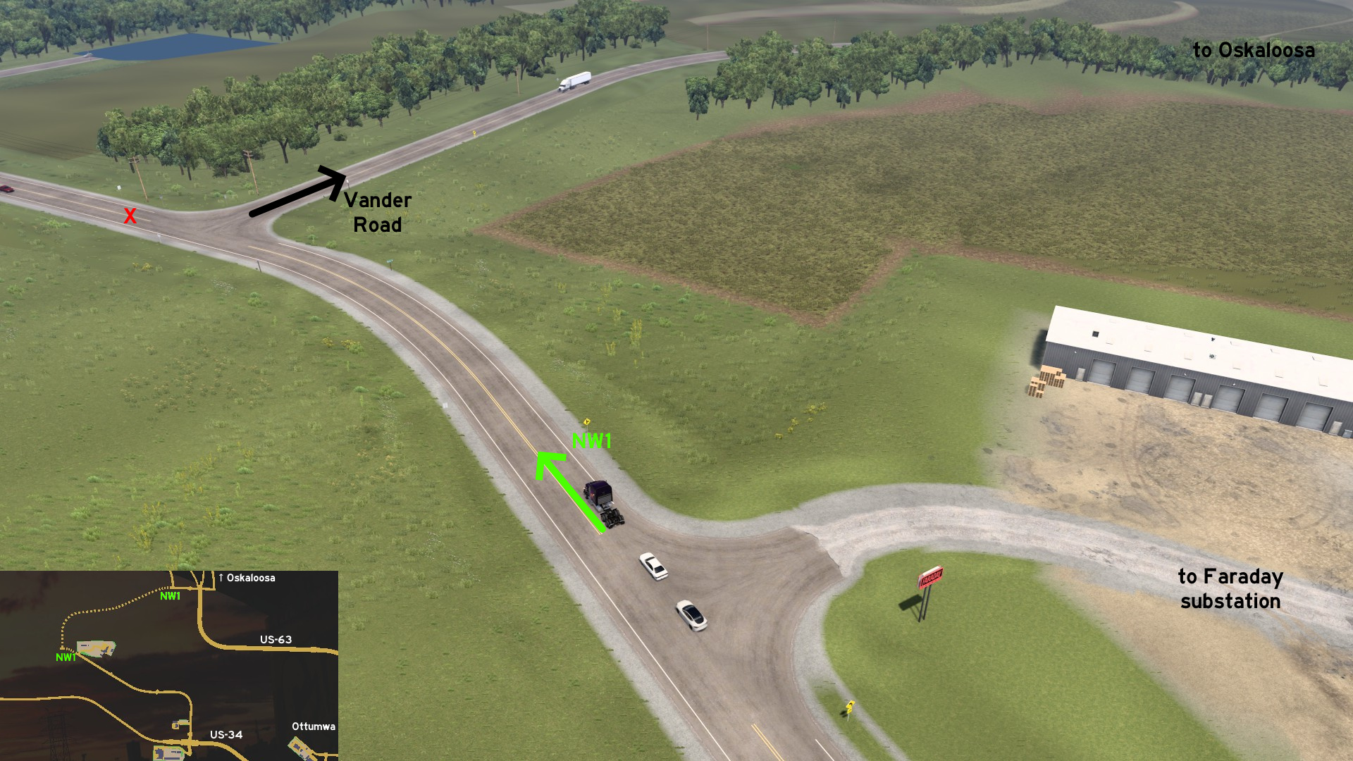 Head to Faraday substation northwest of Ottumwa. Keep forward from the substation entrance, and then turn right (north) into Vander Road. It ends on an US-63 intersection, some miles before the viewpoint of the unmarked town of Oskaloosa.
 West 1 - Car Delivery, Car Parking Only
Category: shortcutDiscovery: Applecorn
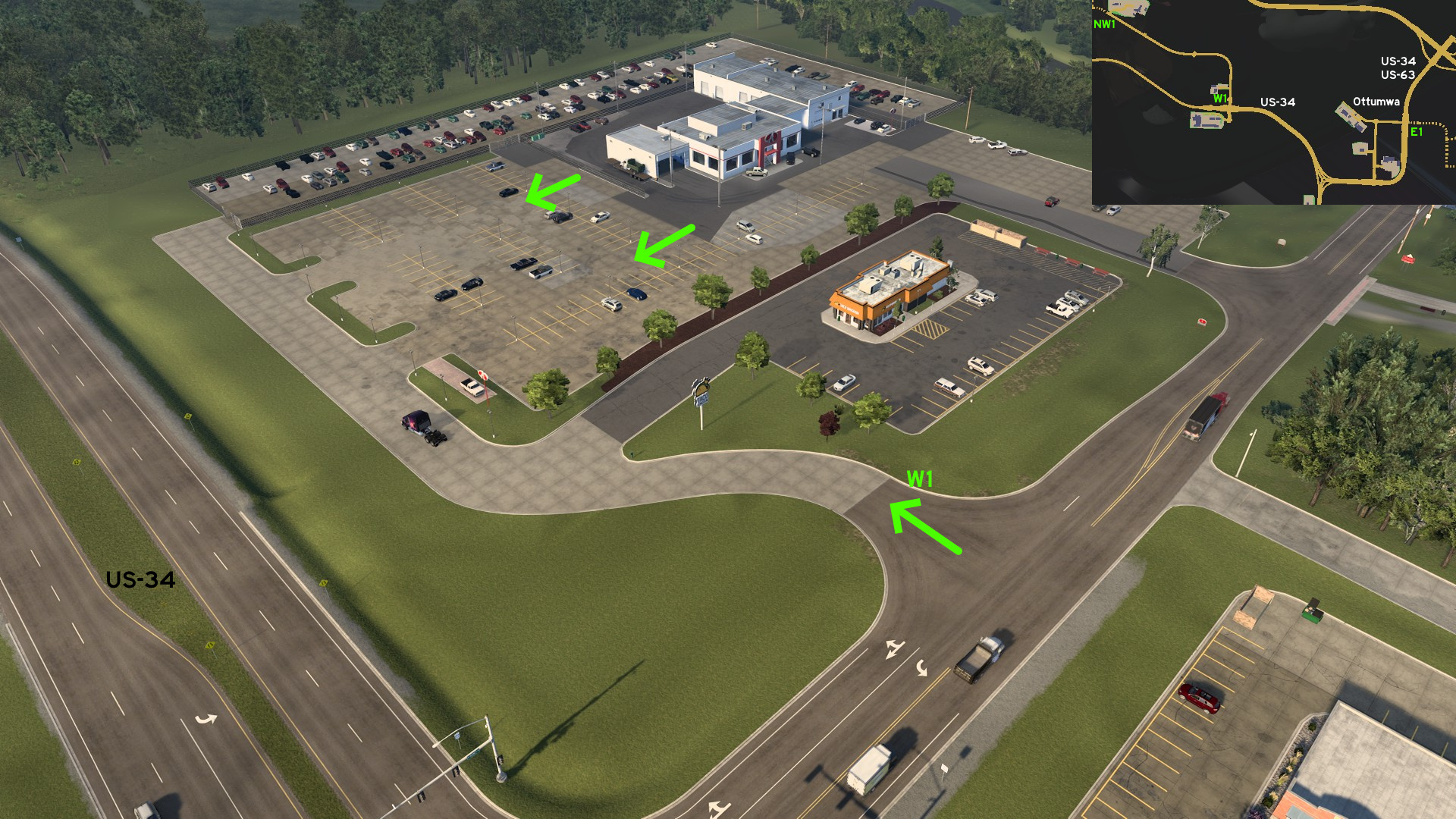 Head to Alis Cars west of Ottumwa. Before reaching dealer main entrance, you can drive through the depot parking lot.
12th DLC, 2023 November 30
Colby
West 1 - Highest Spot On Sunflower State
Category: achievement (Can You Keep a Secret?, Wheat State Explorer), markableDiscovery: TheElderThing, Wide Kemo
Note: in order to unlock Wheat State Explorer achievement, you need to find 10 viewpoints and watch the Director's Cut, and 2 are on hidden roads; please refer to this guide by Xeeran to find all 10 and other achievements
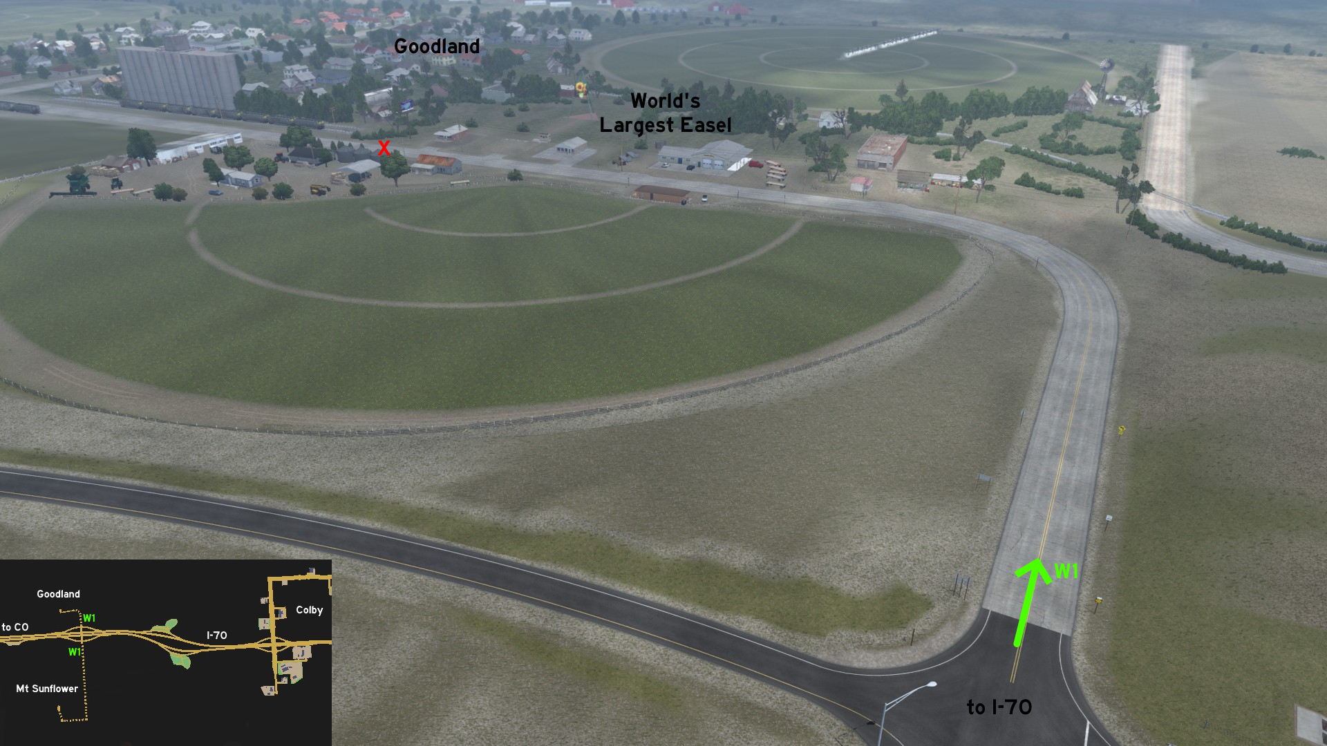 Halfway from Colby to Burlington (Colorado), exit I-70. Drive north and you'll reach the unmarked town of Goodland. You can admire the "World's Largest Easel", a giant replica of Three Sunflowers In A Vase by Van Gogh.
 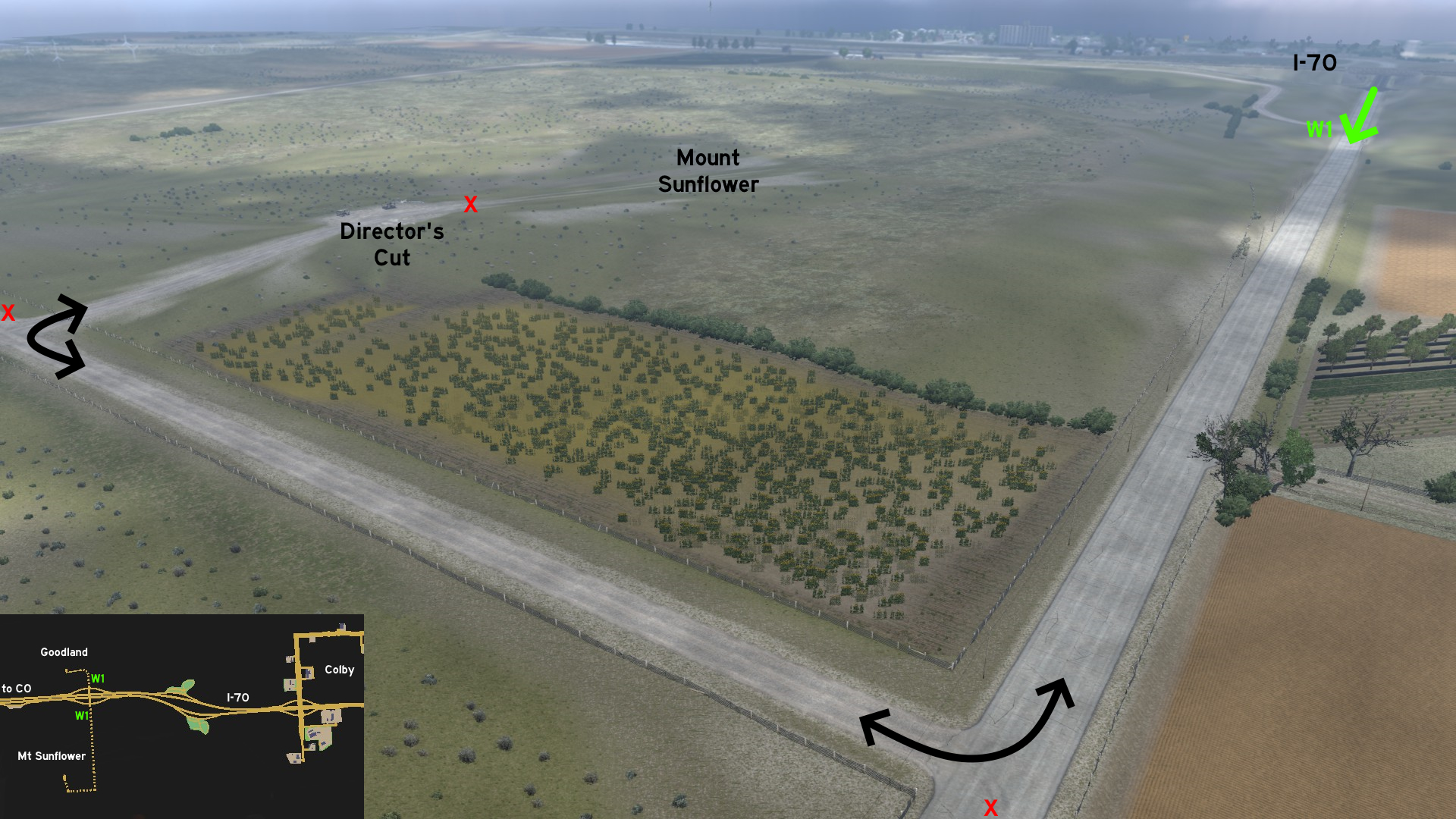 Drive south, turn right twice (west, and then north), and you'll discover the viewpoint for Mount Sunflower. Although it's not really a mount, it's the highest spot on Kansas.
Emporia
Southeast 1 - Save Some Energy
Category: achievement (Can You Keep a Secret?), shortcut, markableDiscovery: OWLCAT
Update: Applecorn
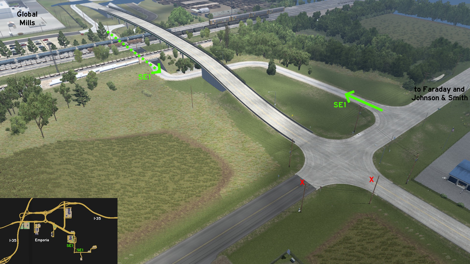 There's a small service road, bordering the city drain system, connecting the roads near Global Mills food factory and the Faraday substation. It doesn't seem to be a safe place to drive though... at least if you're pulling long trailers through tight curves.
 Southeast 2 - No Rest For The Curious
Category: achievement (Can You Keep a Secret?), markableDiscovery: 17F
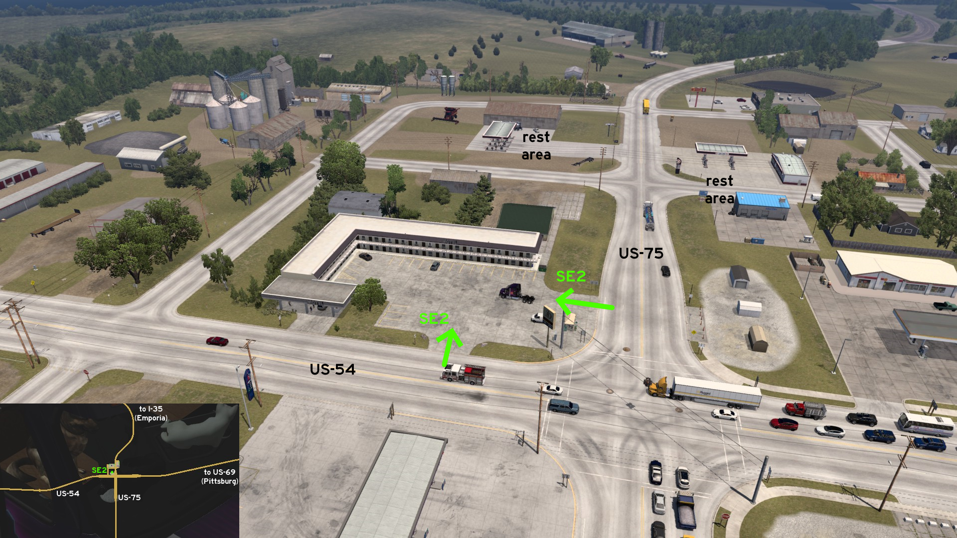 On the northwest corner of the intersection of US-54 and US-75, between Emporia and Pittsburg, there's a motel where you can stop your ride, but you can't take a rest. Luckily there are other two rest areas nearby.
 West 1 - Sleeping Like A Rock
Category: achievement (Can You Keep a Secret?), shortcut, markableDiscovery: FelipeVinhao
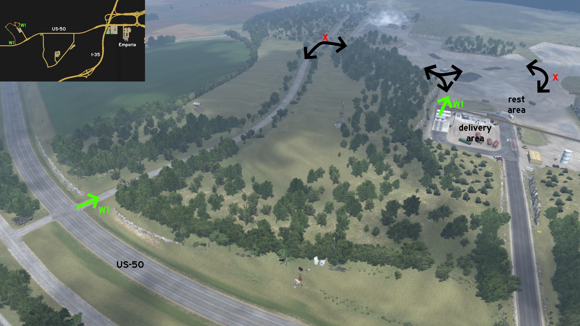 On NAMIQ west of Emporia, there's a secondary entrance that leads to the mining area. There's a gate closing its access, however turning right (east) leads to a rest area north of the delivery area. Now you can take a rest right before your next job.
Garden City
Central 1 - Feed Your Curiosity
Category: achievement (Can You Keep a Secret?), markableDiscovery: Laffey
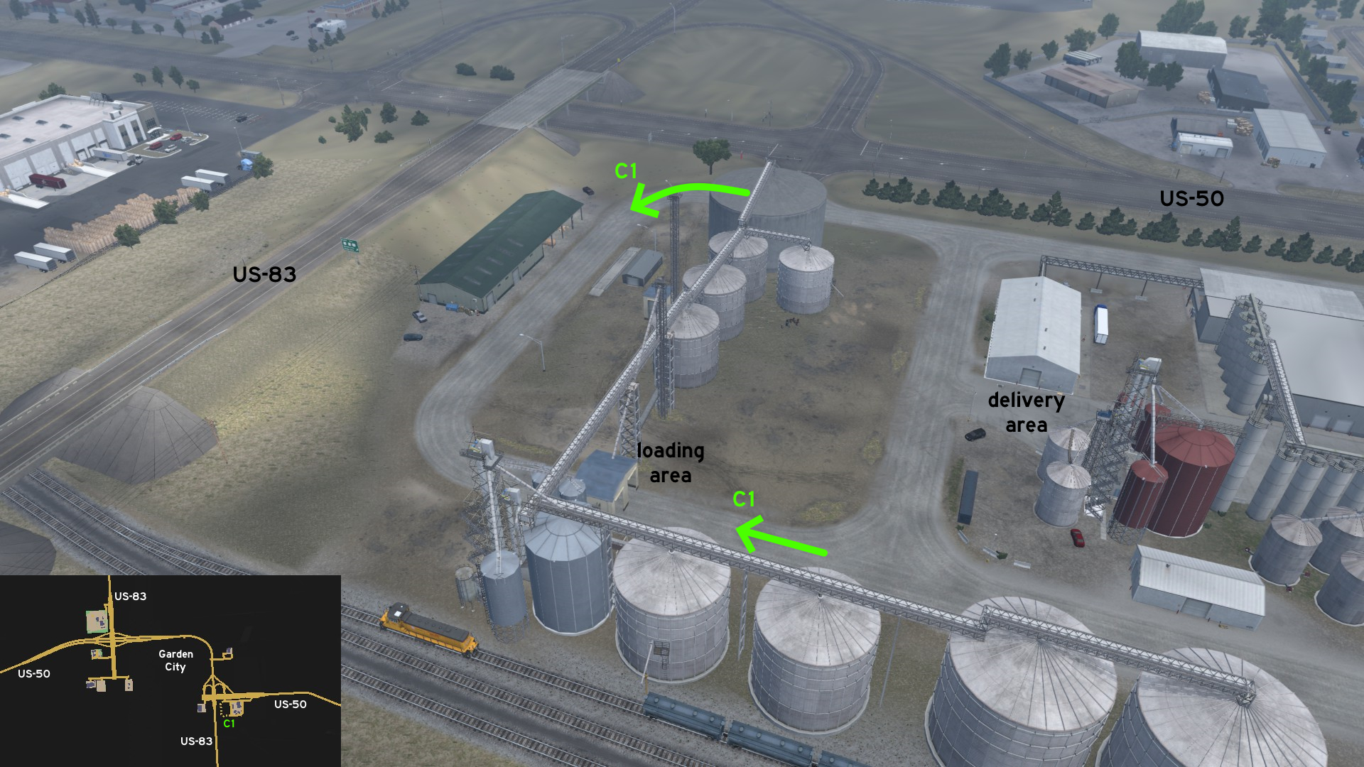 On the west side of Flavorfair food factory, there's a loading area that goes from the main entrance and ends on the back of the property. You can't load your trailer here, but still can use the area for easier maneuvering.
 North 1 - Monument Rocks
Category: achievement (Can You Keep a Secret?, Wheat State Explorer), markableDiscovery: Wide Kemo
Note 1: in order to unlock Wheat State Explorer achievement, you need to find 10 viewpoints and watch the Director's Cut, and 2 are on hidden roads; please refer to this guide by Xeeran to find all 10 and other achievements
Note 2: the path around the rocks is also accessible, but not markable
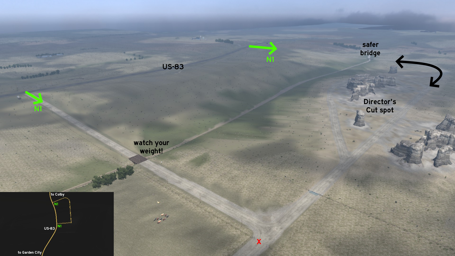 Halfway from Garden City to Colby, you can stop and visit the Monument Rocks. There are 2 entrances: the northernmost one has a concrete bridge crossing the creek, and the southernmost one has a makeshift wooden one with a warning about weight limit - maybe it's a good idea to respect it. Now you can drive around the rock formation and watch a quick video about the landmark.
 South 1 - Finding Dorothy
Category: achievement (Can You Keep a Secret?), easter-egg, markableDiscovery: OWLCAT
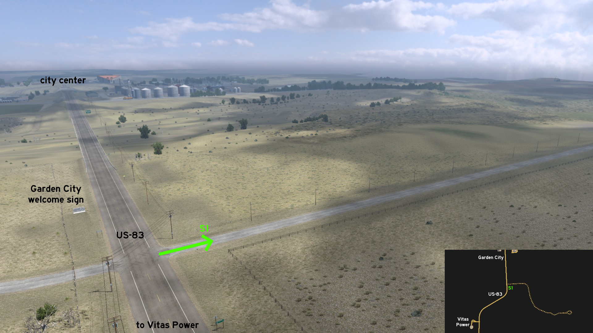 Leaving south Garden City, a crossing near the city welcome sign leads to a mysterious Yellow Brick Road. You may drive for some miles, and think it's a normal farm road...
 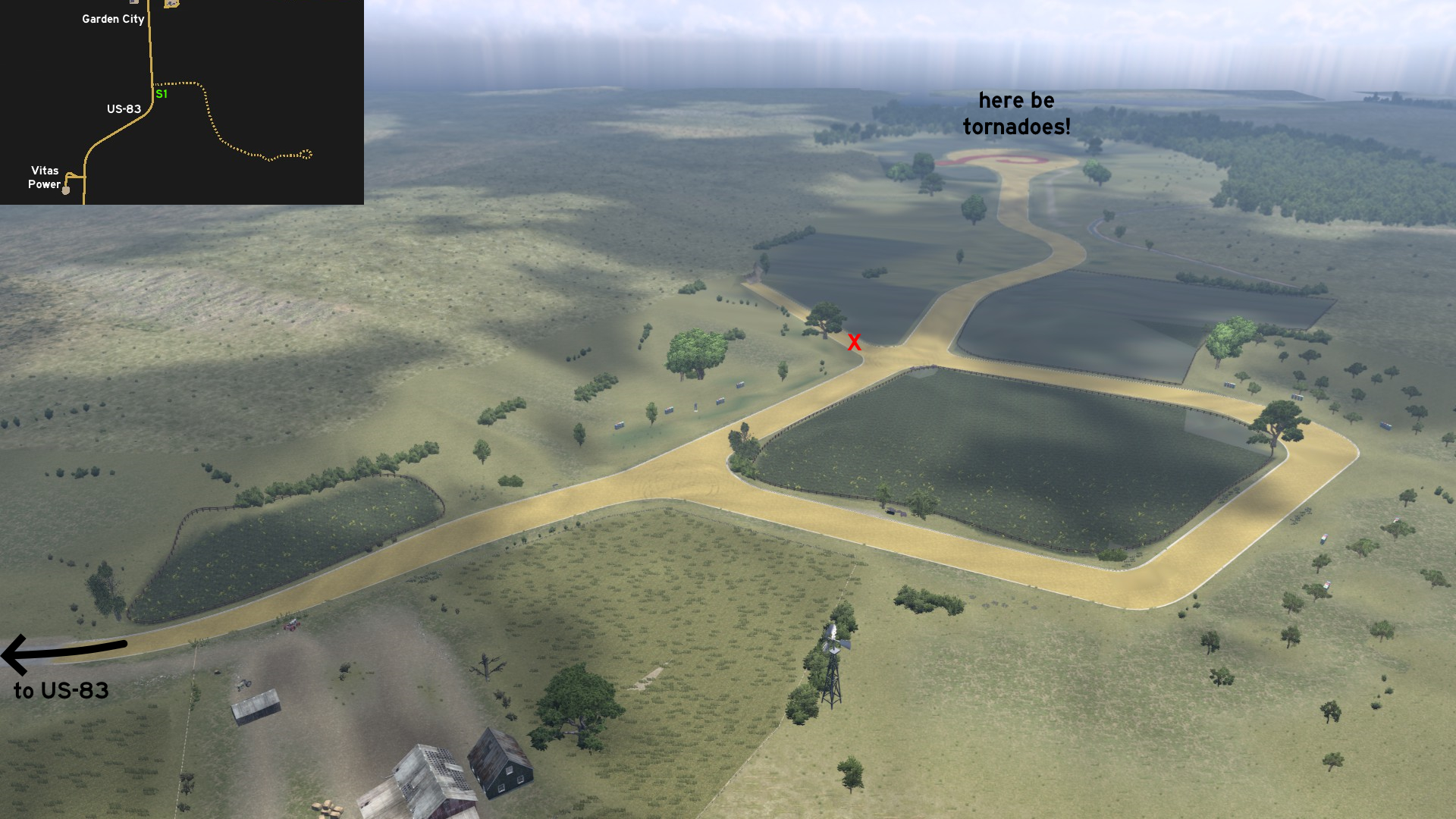 Until you find the actual Yellow Brick Road. The first block is guarded by a furry dog near a bench. The corners are guarded by a tin man and a scarecrow. There are some old farmhouses along the road. And also some weird happenings. You'll find a plaza at the end, and also a cyclone and a pair of ruby slippers. But to return to real world, you'll need to drive all the way back.
Hays
North 1 - Just Go Ahead
Category: shortcutDiscovery: 17F
Update: Skorpionik
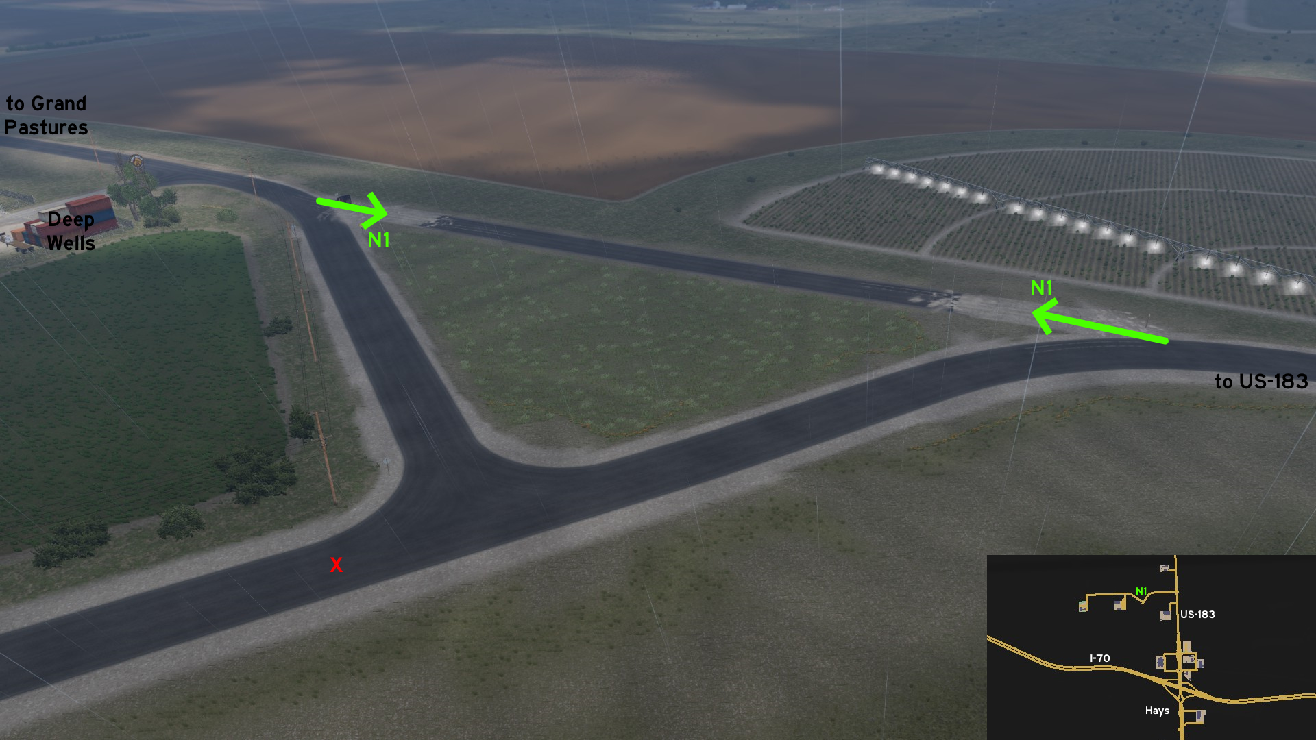 Go north Hays. Head to the road leading to Grand Pastures and Deep Wells. There's a small closed but still usable stretch of road, that seems to be either under construction or to be removed for good, that can be used to go directly to depots.
 North 2 - Through The Gates
Category: sceneryDiscovery: 17F
Update: Skorpionik
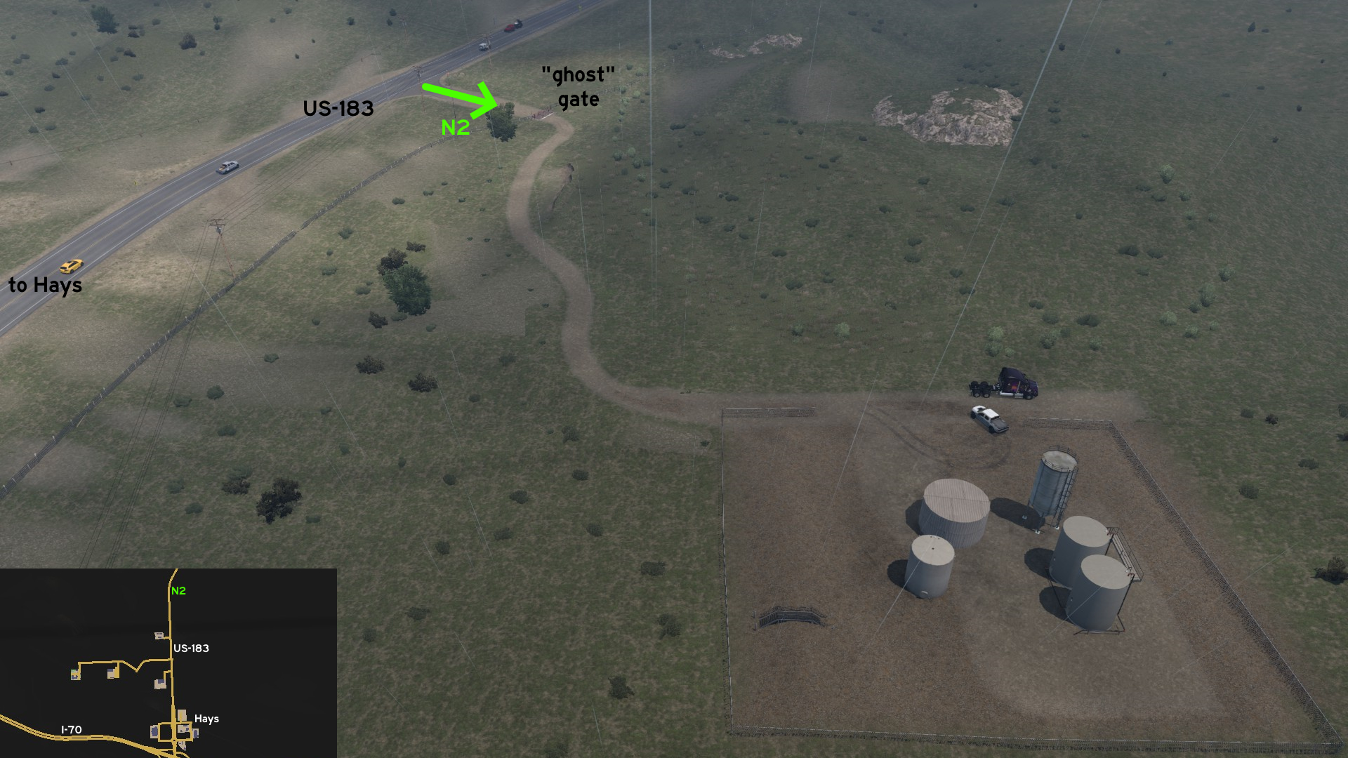 Leave north Hays through US-183. Head to the curve after Petrolucent oil pumps. There's a dirt path leading to a private property, with a gate that you can drive through. Keep driving east until you reach the silo. You can keep going further, but be warned that you may fall to the void!
 South 1 - Between The Crossings
Category: shortcutDiscovery: Applecorn
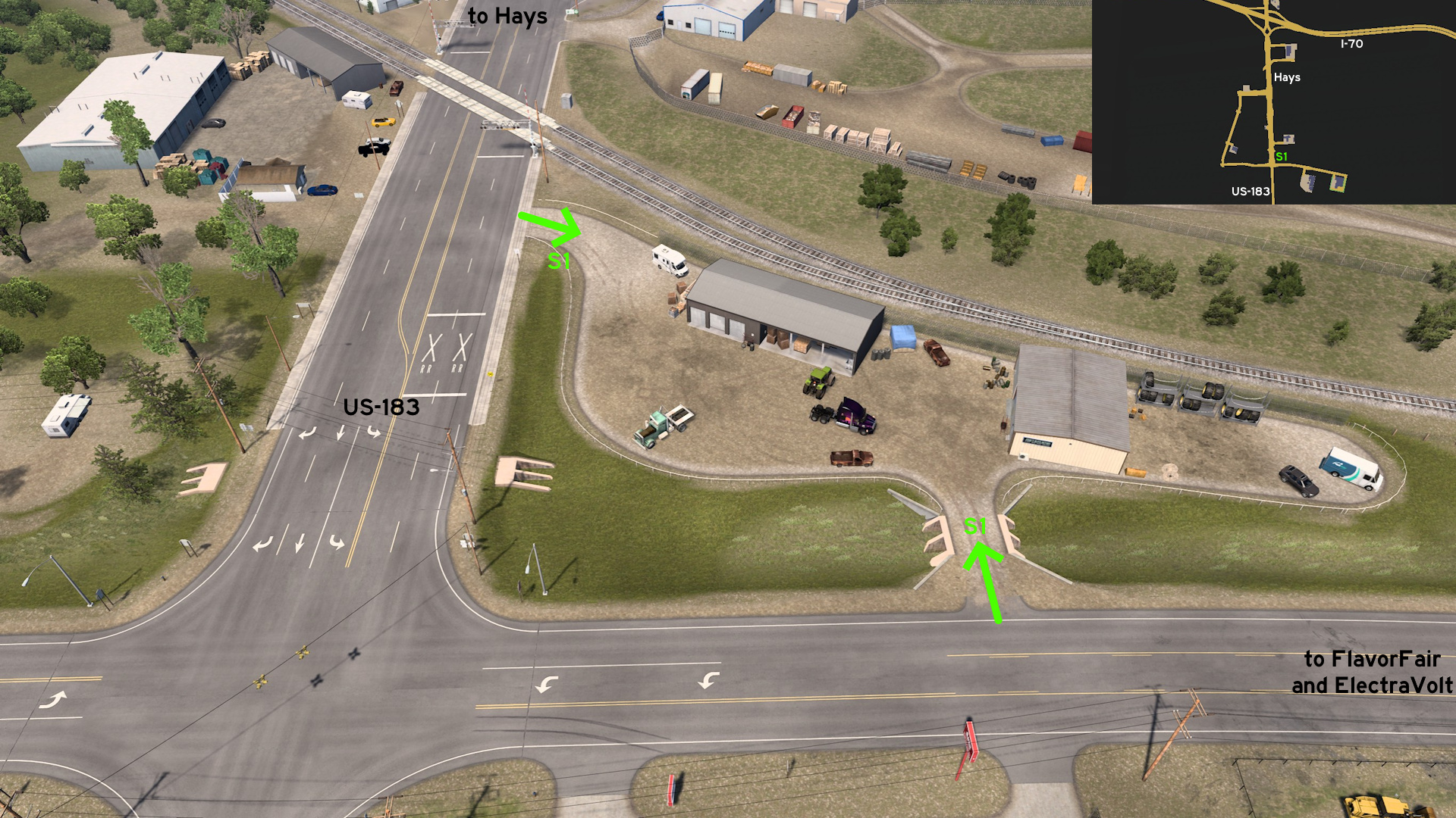 Head south Hays. Between the raildroad crossing and the crossing between US-183 and the road leading to FlavorFair and ElectraVolt, there's a parking lot that can be used as a detour, but not to rest.
Hutchinson
East 1 - Train Loop
Category: sceneryDiscovery: Zest
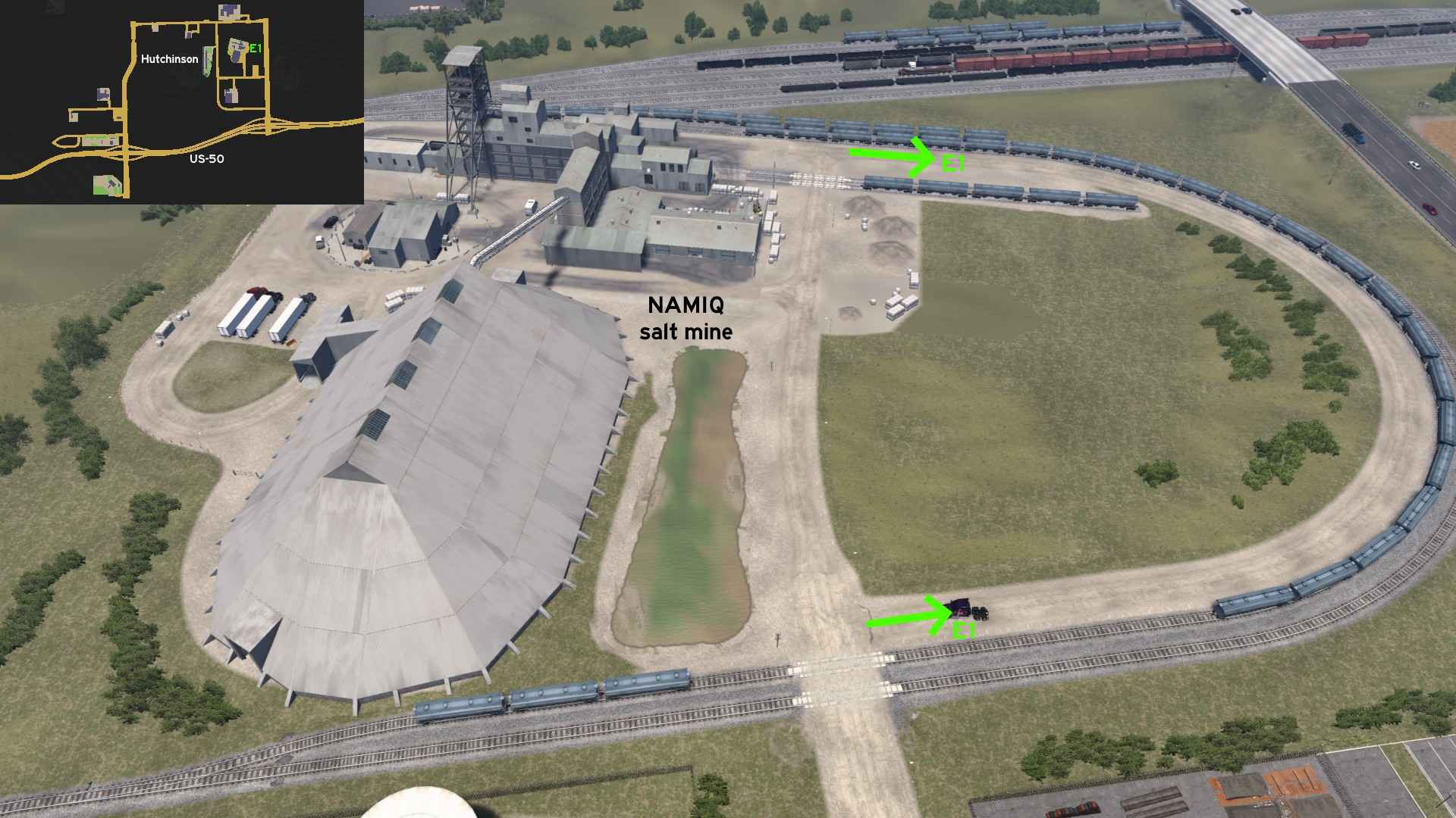 Head east of NAMIQ salt mine. There's a path running along a rail loop.
 West 1 - Kent Farm
Category: achievement (Can You Keep a Secret?), easter-egg, markableDiscovery: Wide Kemo
Update: TW
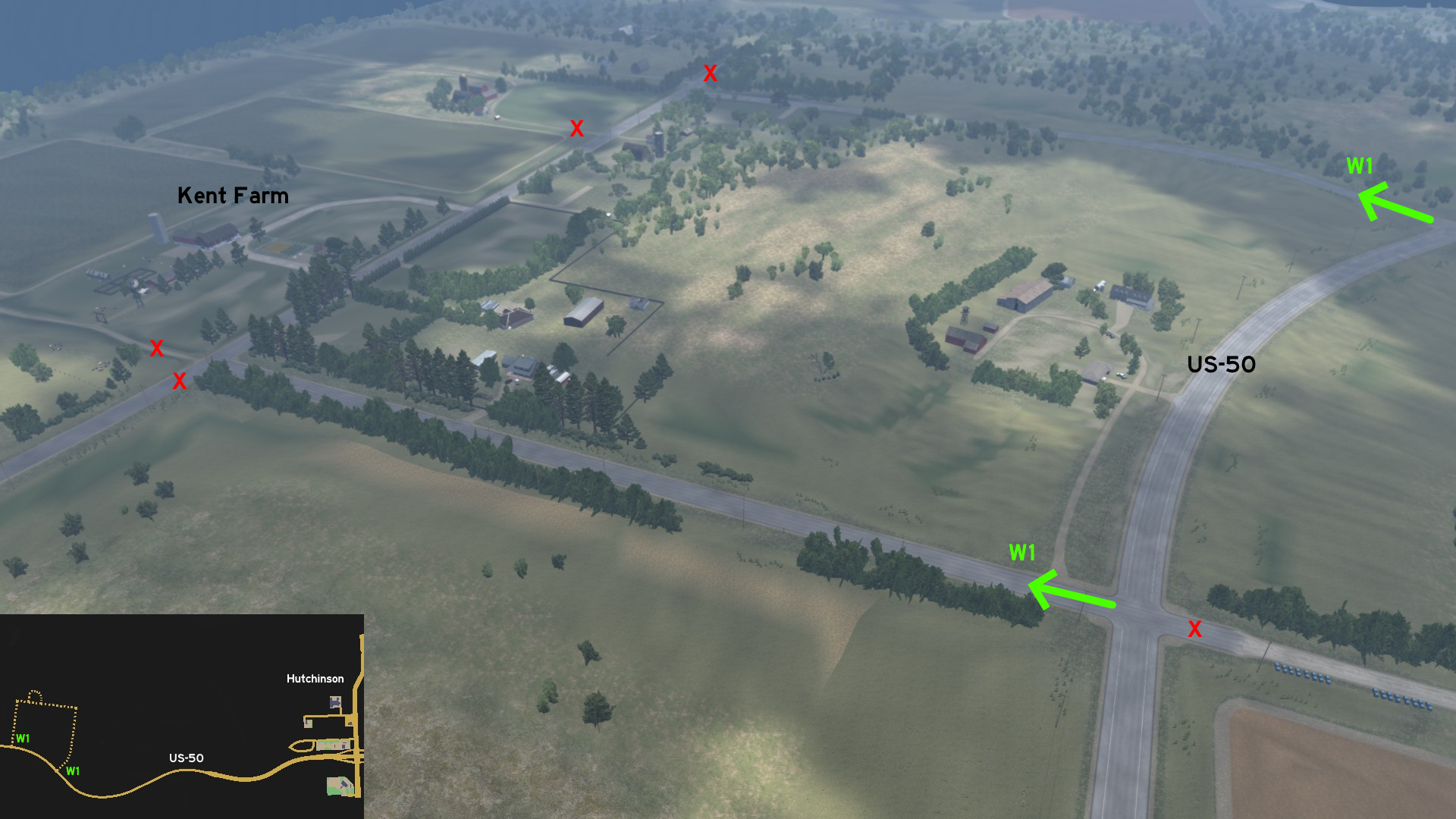 Leave west Hutchinson through US-50. Halfway to US-183, leave US-50 north through any of the 2 accessible roads. Drive the loop leading to Kent family property. Head to the barn, and you'll find a tractor placed on a strange position and a familiar uniform hung on clothes line - apparently they're keeping the most powerful being on the planet on a small Kansas farm.
Kansas City
See also Kansas City on Missouri
Discovery: OWLCAT
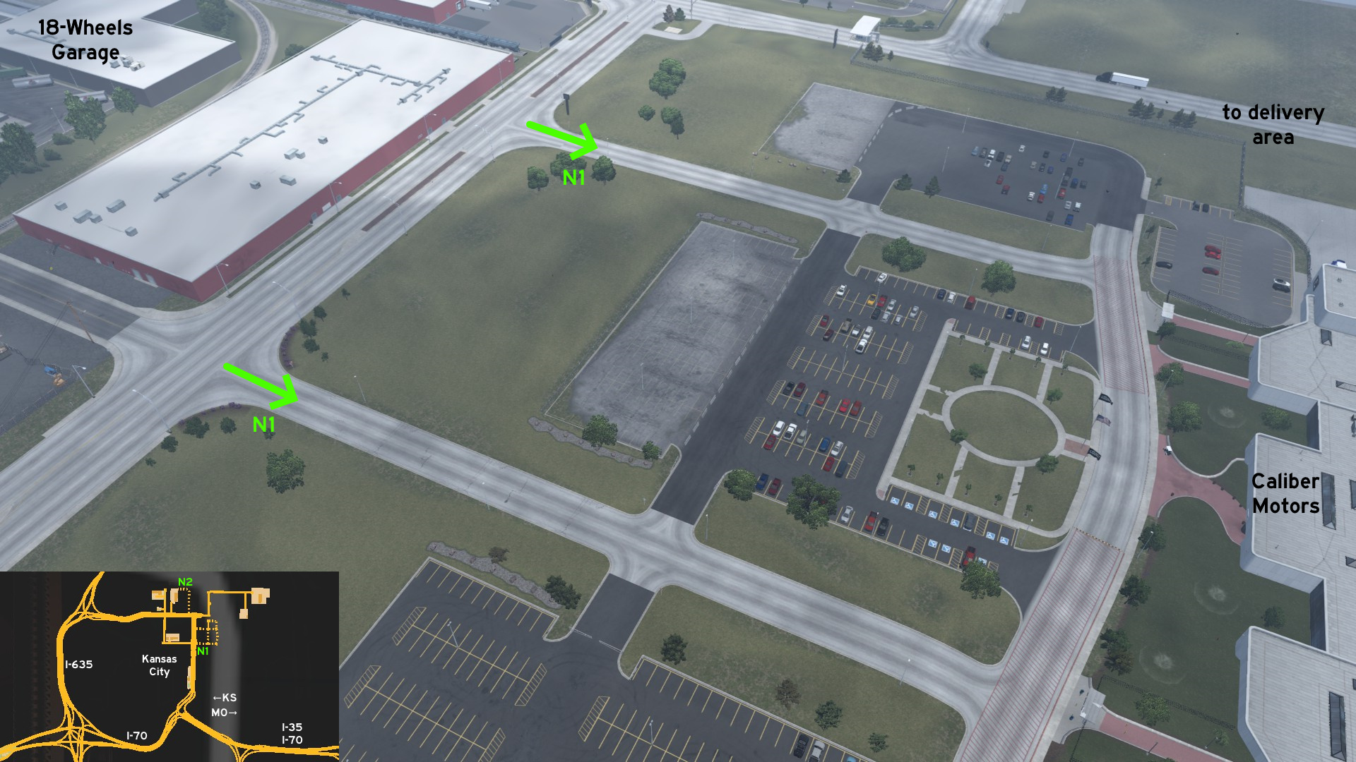 Head to Caliber Motors factory, east of 18-Wheels Garage on Kansas City. Before doing a job for the company, you can pay the place a visit. Just be careful as the parking lot isn't appropriate for trucks.
Discovery: Cyanlix, 17F
Update: Epic Trucker Arch
Note: on version 1.54, Equos Power was changed to Enterpriser
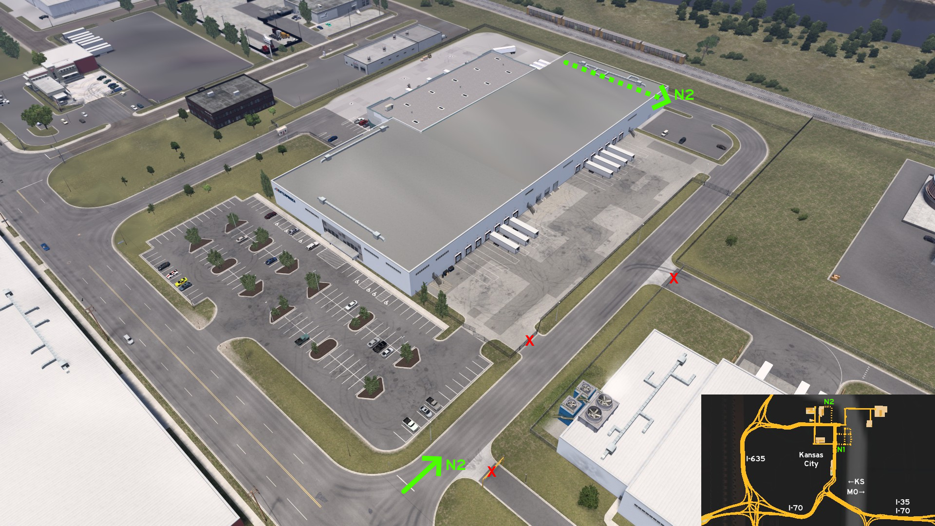 There's a secondary entrance east of Enterpriser depot, that leads directly to the delivery area, depending on the chosen unload spot for your job.
Description: of trains and cars, under I-635
Discovery: FelipeVinhao
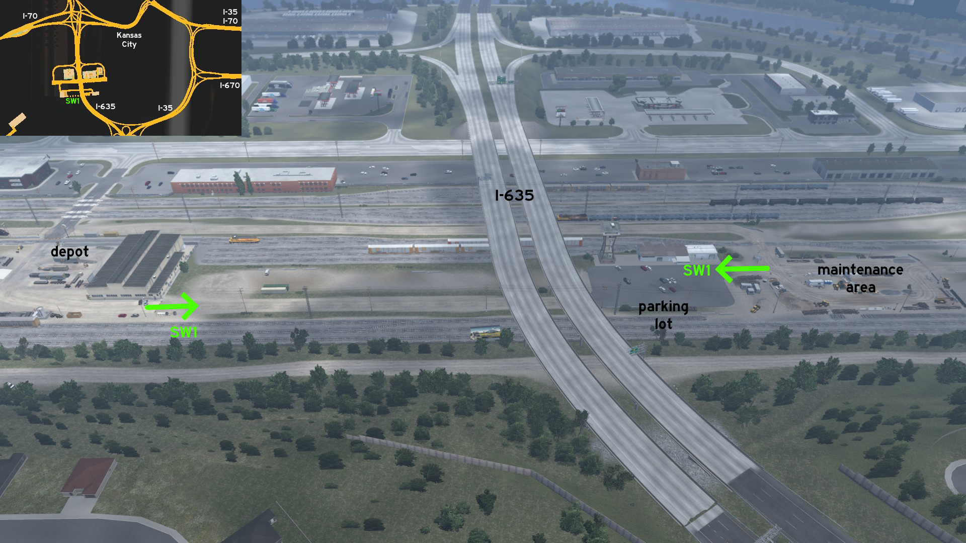 To go directly from Johnson & Smith depot to the maintenance area, without returning to main roads and risking wasting time waiting on railroad crossing, you can drive through the parking lot and the dusty road below I-635.
North 1 - From 18-Wheels To 4-Wheels
Category: achievement (Can You Keep a Secret?), markableDiscovery: OWLCAT
Head to Caliber Motors factory, east of 18-Wheels Garage on Kansas City. Before doing a job for the company, you can pay the place a visit. Just be careful as the parking lot isn't appropriate for trucks. North 2 - Enterprise Shortcut
Category: achievement (Can You Keep a Secret?), shortcut, markableDiscovery: Cyanlix, 17F
Update: Epic Trucker Arch
Note: on version 1.54, Equos Power was changed to Enterpriser
There's a secondary entrance east of Enterpriser depot, that leads directly to the delivery area, depending on the chosen unload spot for your job. Southwest 1 - Of Trains And Cars
Category: achievement (Can You Keep a Secret?), shortcut, markableDescription: of trains and cars, under I-635
Discovery: FelipeVinhao
To go directly from Johnson & Smith depot to the maintenance area, without returning to main roads and risking wasting time waiting on railroad crossing, you can drive through the parking lot and the dusty road below I-635.
Marysville
East 1 - At The Cemetery Gates
Category: sceneryDiscovery: 17F
Update: Skorpionik
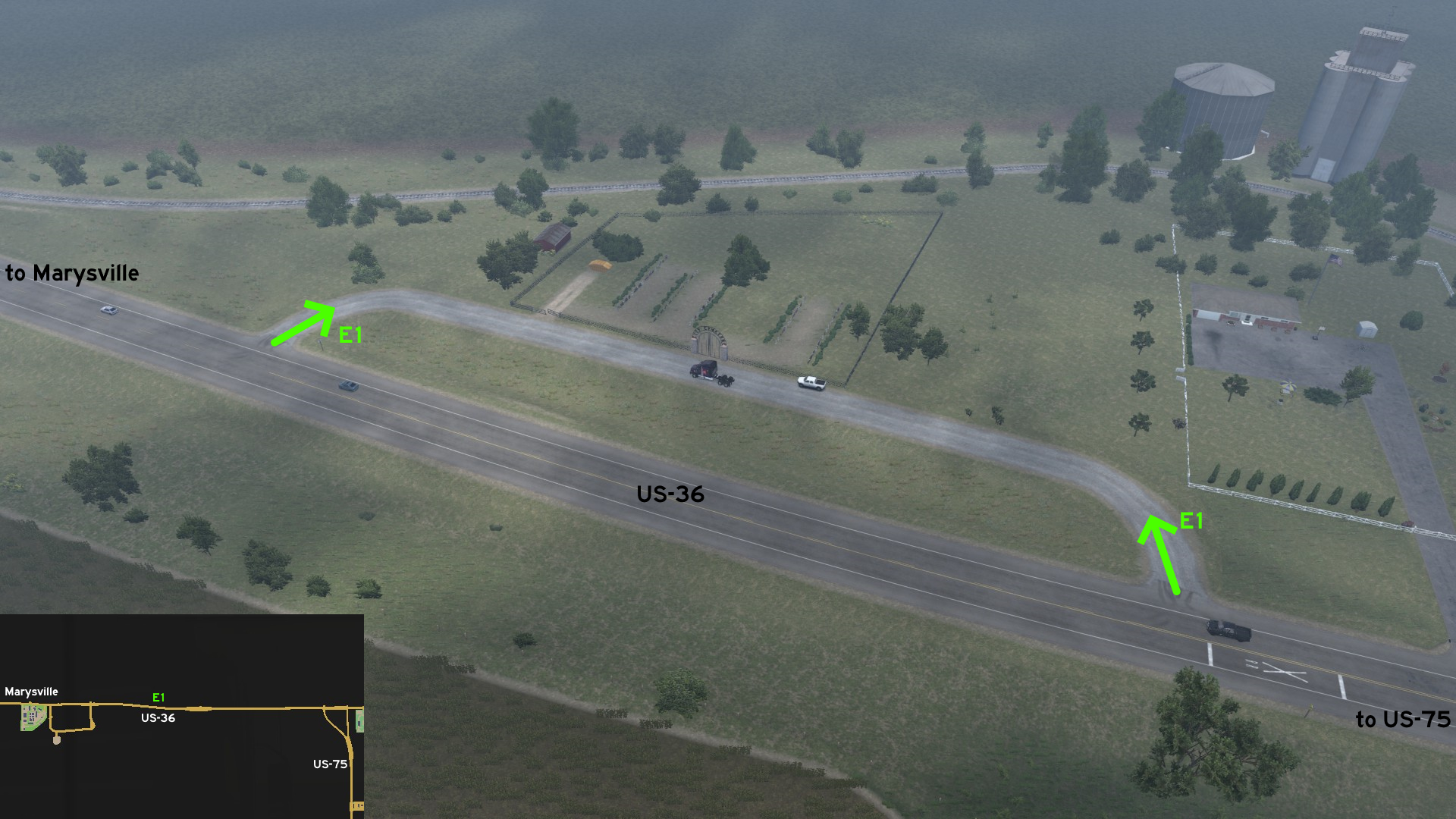 East of Marysville, before a railroad crossing, there a path leading to the city cemetery. On map, it's easy to be located, as it runs around the US-36 shield.
 East 2 - Meeting The Colleagues
Category: sceneryDiscovery: 17F
Update: Skorpionik
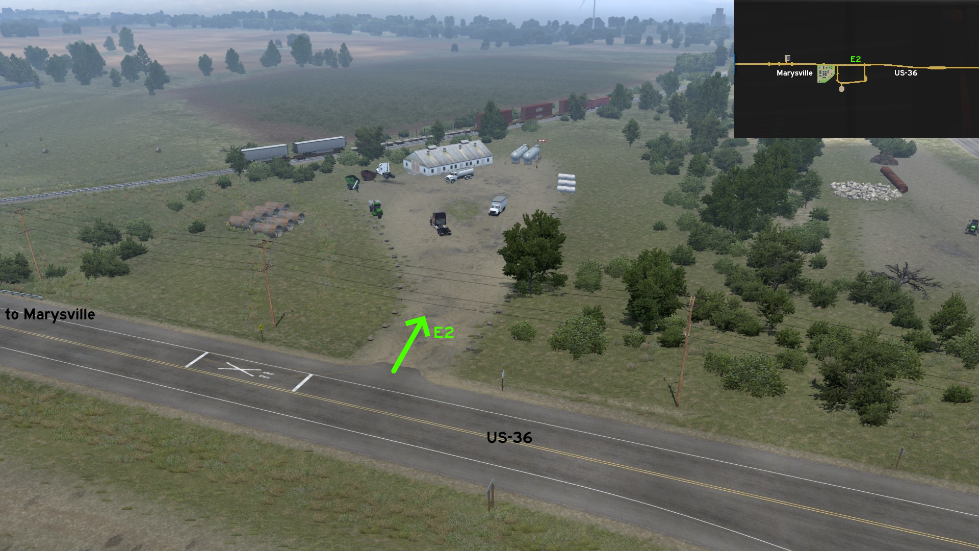 Just across the loop that leads to a Vitas Power construction site, east of a railroad crossing, there's a spot where you can use as a turnaround, and find other trucks and heavy machinery.
 West 1 - No Rest Or Fuel For You
Category: sceneryDiscovery: 17F
Update: Skorpionik
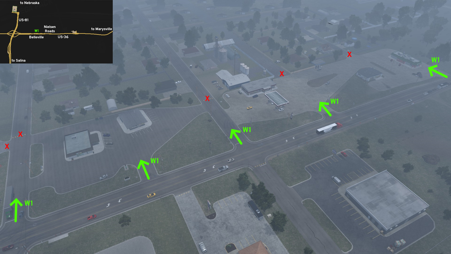 West of Marysville, on the unmarked town of Belleville, between the US-81 junction and the road maintenance area, there's a huge accessible fuel station and rest area with some stores. But none can be used by you. However, you can use the area as a turnaround.
Phillipsburg
East 1 - Center Of The Continental USA
Category: achievement (Can You Keep a Secret?), markableDiscovery: TheElderThing, joshuatree37
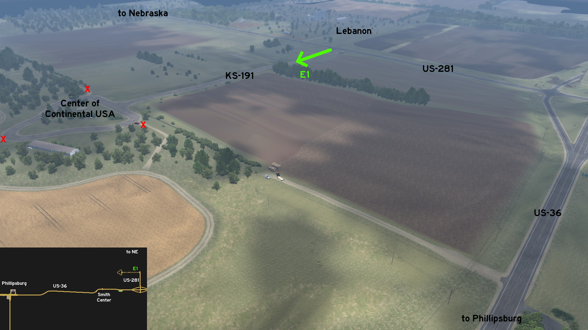 East of Phillipsburg and the unmarked town of Smith Center, take the exit to US-281 and head to Nebraska. Turning west near the unmarked town of Lebanon on KS-191, you'll reach the landmark of the geographical center of the contiguous 48 states, and also the nearby chapel. After discovering the area, it's easy to be spotted by its shape of an arrow on the map.
Pittsburg
Central 1 - Quick Stop For Fast Food
Category: sceneryDiscovery: 17F
Update: Skorpionik
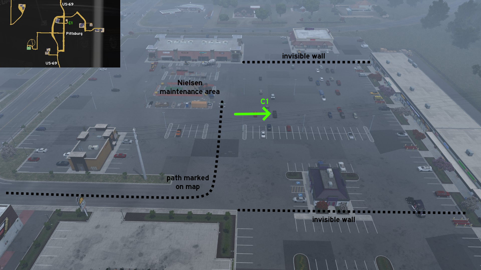 The area east of where Nielsen Roads is working on some maintenance is mostly accessible, just blocked by some invisible walls north and south. As reference, the north limit is marked by the building right behind the maintenance area; the south limit is marked by the sidewalk of the road that leads to it, and the Donut Planet close to it.
 West 1 - Long Drive Through Sunflowers
Category: achievement (Can You Keep a Secret?), shortcut, markableDiscovery: OWLCAT
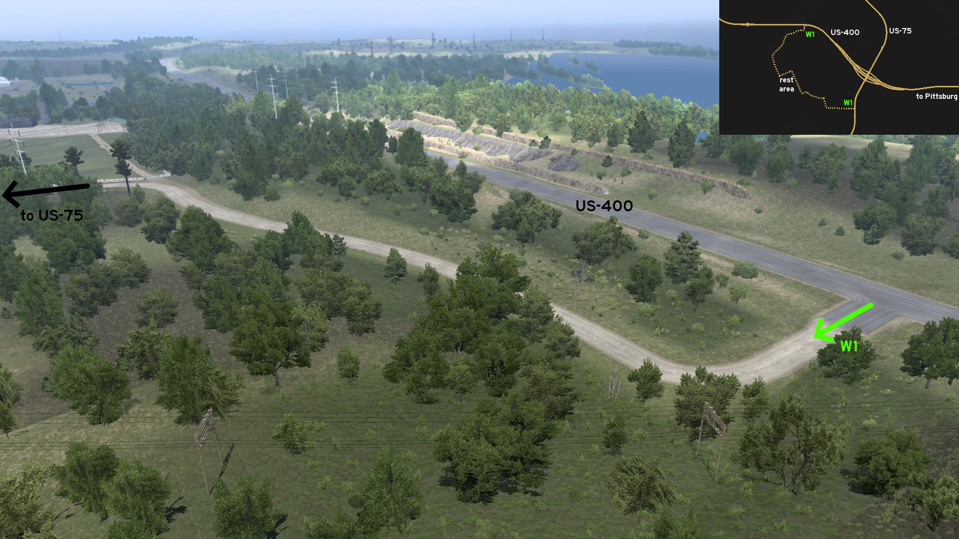 West of Pittsburg, there's a long farm road connecting US-75 and US-400. The north entrance is on US-400, some miles after the intersection, and before the rest area halfway to Wichita.
 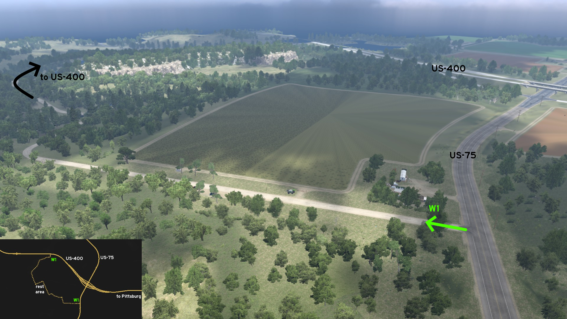 The south entrance is some meters before the railroad crossing on US-75. The route runs through a huge sunflower plantation, and has a rest area near another rail crossing, but this one without sound or light warning, so drive careful.
 West 2 - Rock And Roll
Category: achievement (Can You Keep a Secret?), markableDiscovery: Cyanlix, 17F
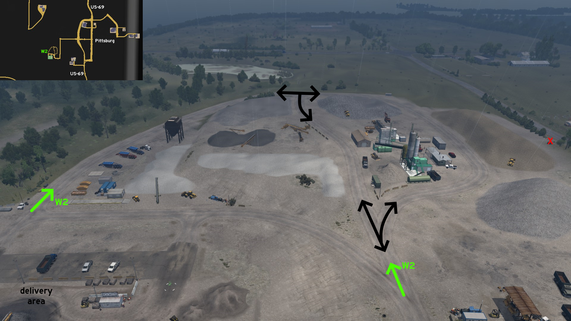 North of NAMIQ, there's a huge loop dusty road that can be used for easier maneuvering when pulling long trailers to or from the delivery area. However it can't be used as a shortcut to main roads. You can find some rest area for employees, and also some abandoned vehicles.
Salina
North 1 - From Civil Works Through The Fields
Category: shortcutDiscovery: FelipeVinhao
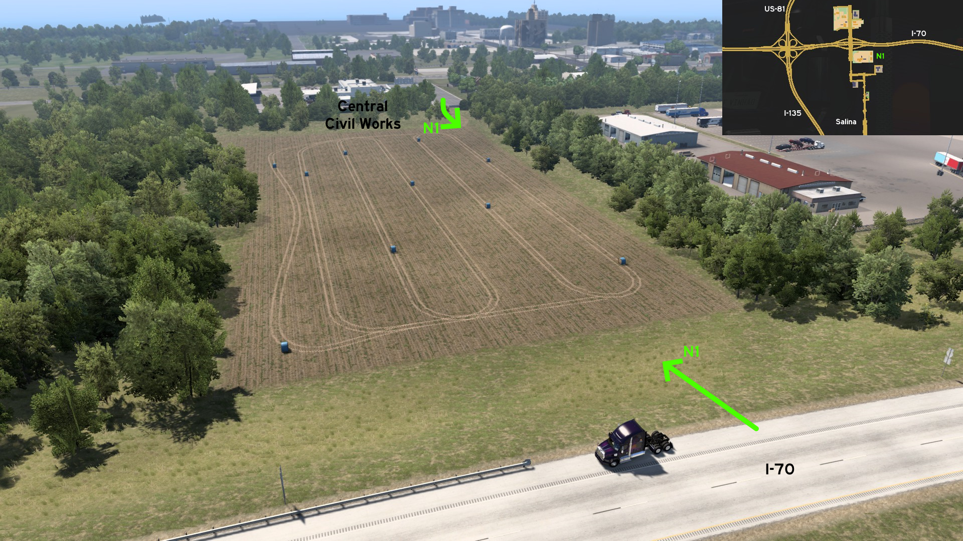 From the Central Civil Works depot found north of Salina, there's a hole on the wall at the dead end street. There are some plowed fields, and it leads to an unprotected section of I-70 eastbound. If you plan to return to freeway here, just enter carefully.
15th DLC, 2025 April 03
Cape Girardeau
Northeast 1 - Behind The Wall
Category: achievement (Ozark Explorer), markableDiscovery: Applecorn
Note: in order to unlock Ozark Explorer achievement, you need to find at least 12 viewpoints and watch the Director's Cut, and 2 are on hidden roads; please refer to this guide by Xeeran to find all 17 and other achievements
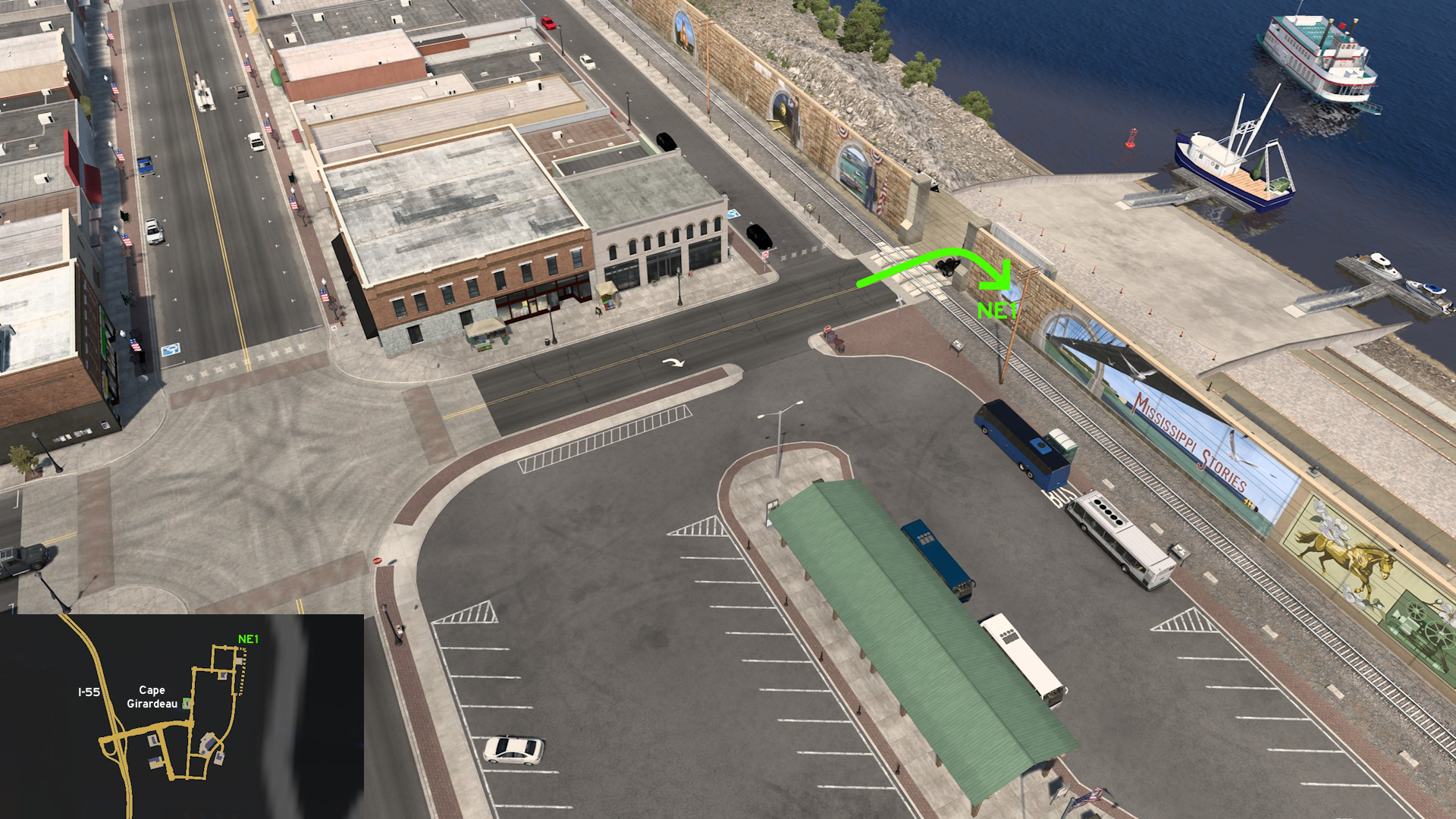 Head northeast Cape Girardeau. When you reach Nielsen road work, you'll receive a message that a viewpoint is nearby, hinting its entrance. Cross the railroad lines and turn right to find the viewpoint and drive along Mississippi river.
 Southeast 1 - No Weight Limit
Category: sceneryDiscovery: Applecorn
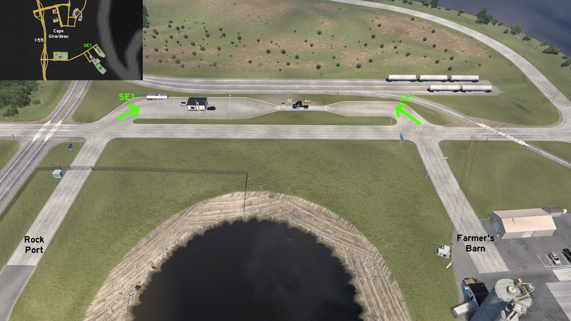 Head southeast Cape Girardeau. Across the entrance of both Rock Port and Farmer's Barn, you'll find both entrances to the disabled weigh station.
Jefferson City 🏛️
Southwest 1 - Drive Along The Lake
Category: shortcut, markableDiscovery: FelipeVinhao
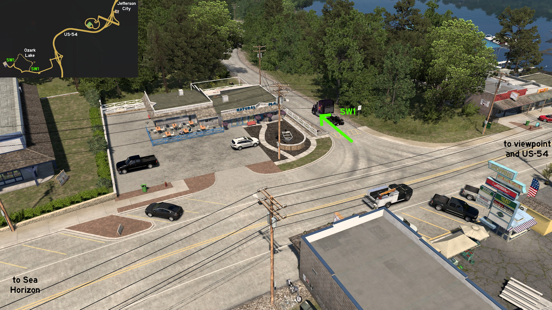 Leave southwest Jefferson City through US-54. Reach the unmarked town of Lake Ozark, where Sea Horizon depot is located. Some meters after Bagnell Dam viewpoint, there's an almost hidden narrow road along the lake starting at a restaurant. The other access isn't so hidden, close to depot entrance.
Joplin
North 1 - Small But Not So Hidden
Category: scenery, markableDiscovery: FelipeVinhao
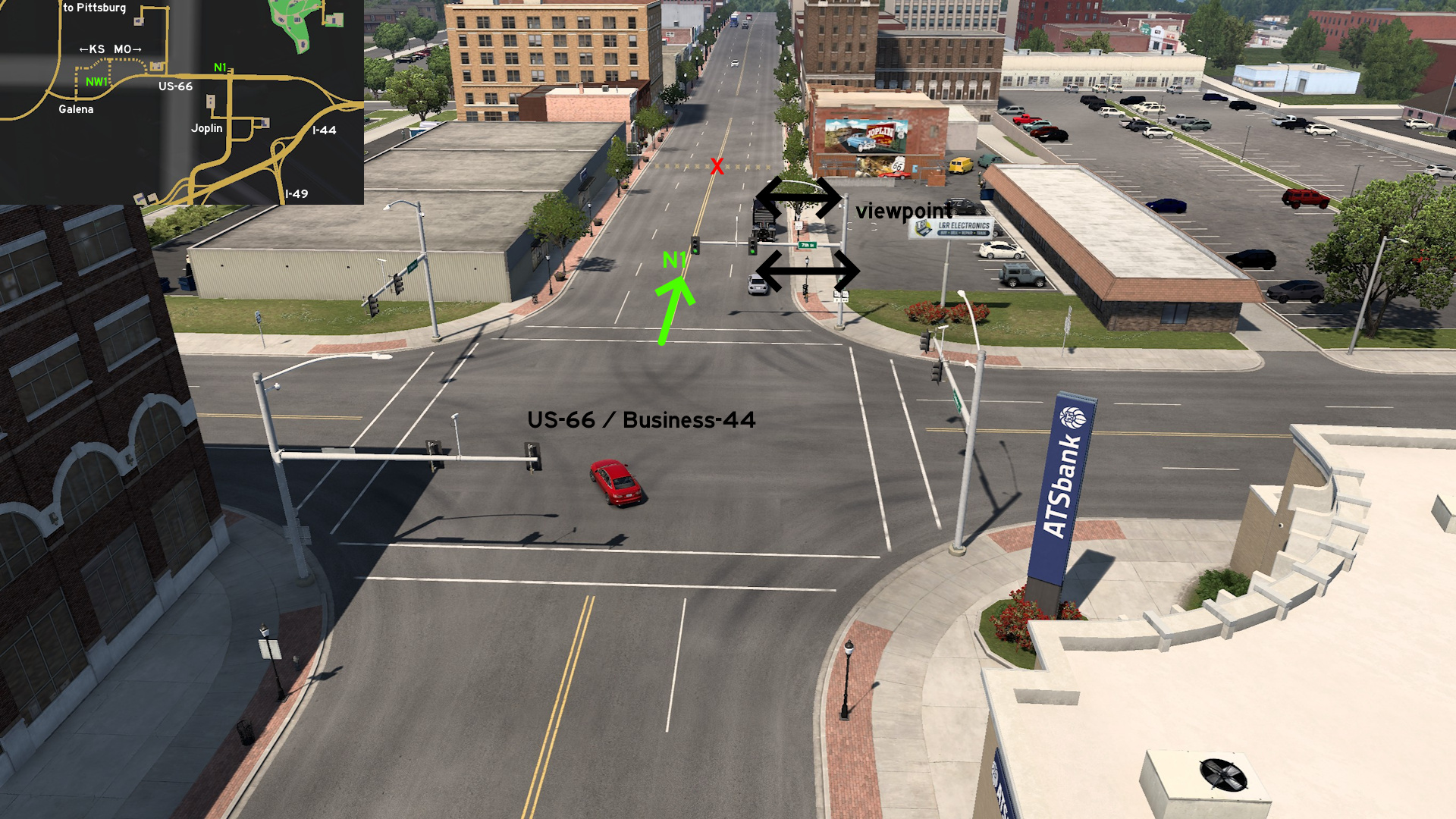 Head north Joplin, where Route 66 Mural Park can be found. Turn north on Main Street - to reach the viewpoint, you'll automatically discover the unmarked road.
 Northwest 1 - Cars, Trucks And Hotrods On The Border
Category: achievement (Can You Keep a Secret?), easter-egg, markableDiscovery: OWLCAT
Update: Applecorn
Note 1: as hidden roads are partially on Kansas, it may unlock the related Kansas achievement
Note 2: before version 1.54 (Missouri release), the closest city was Pittsburg; after 1.54, the hidden roads were expanded east and Joplin was added
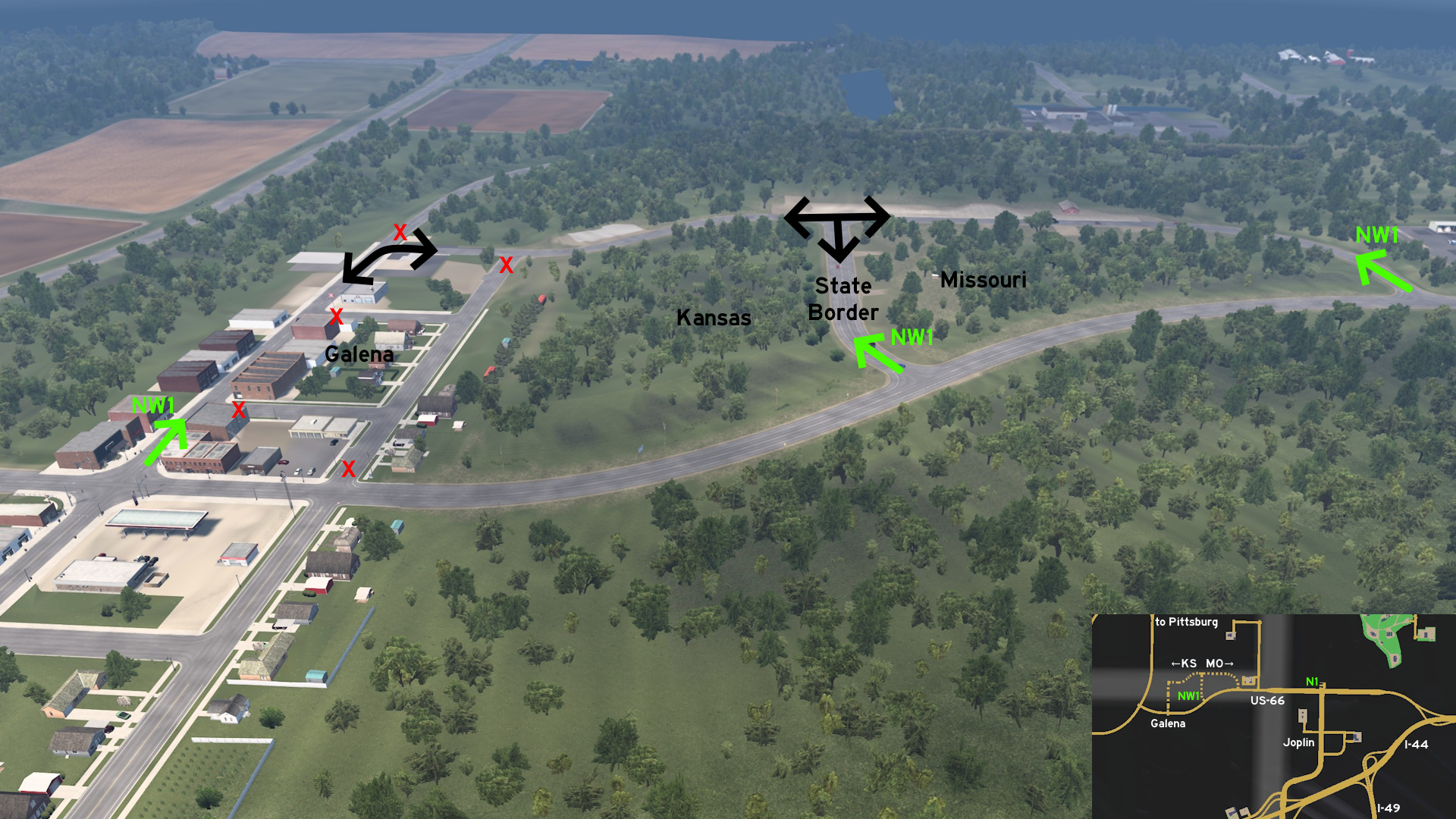 Head northwest of Joplin, and south of Pittsburg (Kansas). The hidden roads are on both states: the historic US-66 on Missouri, the State Line Road that ends on a hotrod bar located on both states, and the Main Street of the unmarked town of Galena on Kansas where you'll find some trucks that look familiar.
Kansas City
See also Kansas City on Kansas
Discovery: Oni
Update: Cyanlix
Note: the dusty path isn't markable
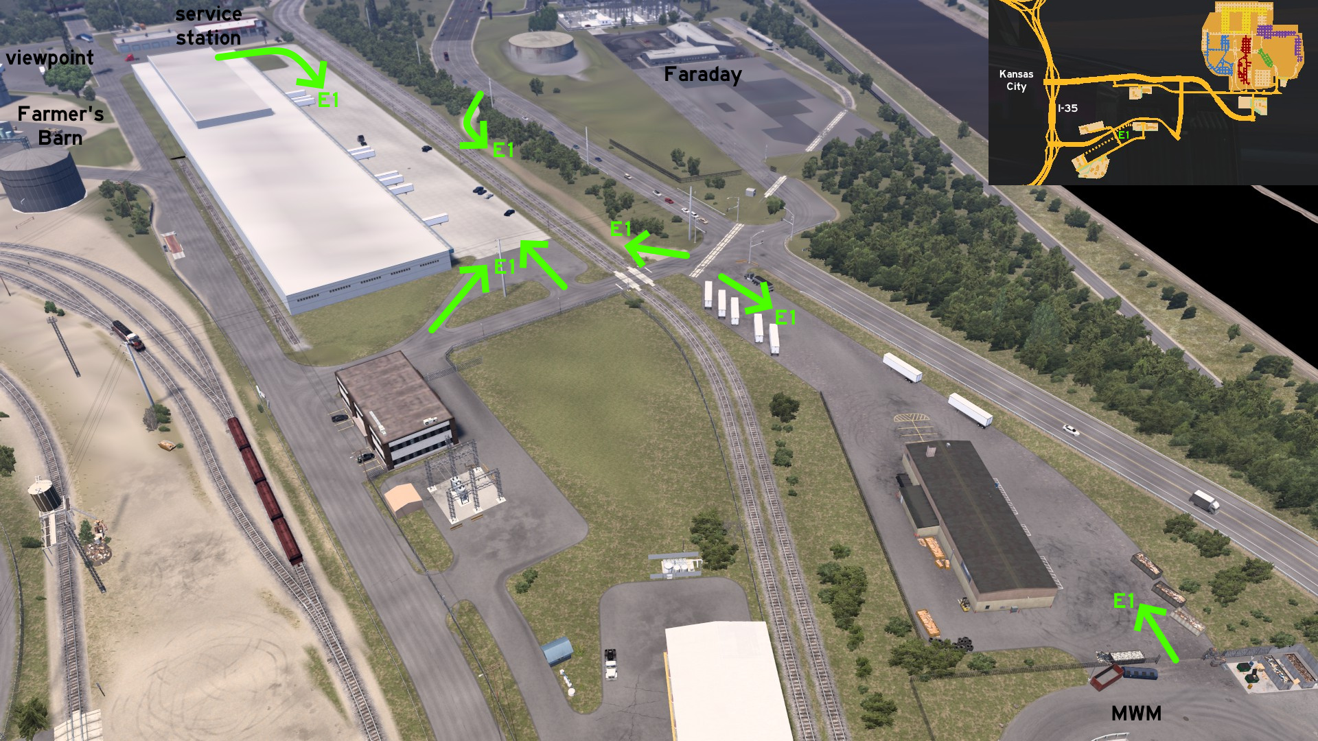 Head to the service station close to Farmer's Barn depot. The concrete-covered area can be used as a shortcut back to main roads. North of nearby railroad crossing, the parking lot can be used as a shortcut to Municipal Waste Management depot, and the dusty path as a shortcut to the main road close to Faraday substation.
East 1 - From Service Station To Substation
Category: shortcut, markableDiscovery: Oni
Update: Cyanlix
Note: the dusty path isn't markable
Head to the service station close to Farmer's Barn depot. The concrete-covered area can be used as a shortcut back to main roads. North of nearby railroad crossing, the parking lot can be used as a shortcut to Municipal Waste Management depot, and the dusty path as a shortcut to the main road close to Faraday substation.
Kirksville
Southeast 1 - Pleasant Drive Around Hannibal
Category: scenery, markableDiscovery: Applecorn
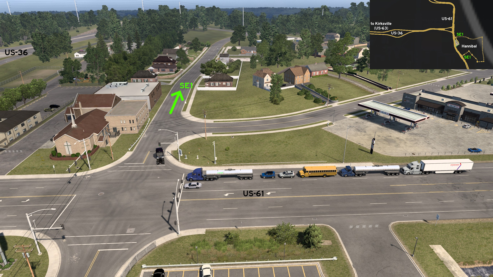 Leave south Kirksville through US-63 and head east through US-36. Leave on US-61 and head to the fuel station south. Instead of going to the fuel station, continue east on Pleasant Street. You can drive around the unmarked town of Hannibal, along the Mississippi river, and then back to US-61 on the crossing where you can find a Pizza House and a Dirk's Fried Chicken.
Maryville
North 1 - Loop To Farm And Wind Farm
Category: shortcut, markableDiscovery: Applecorn
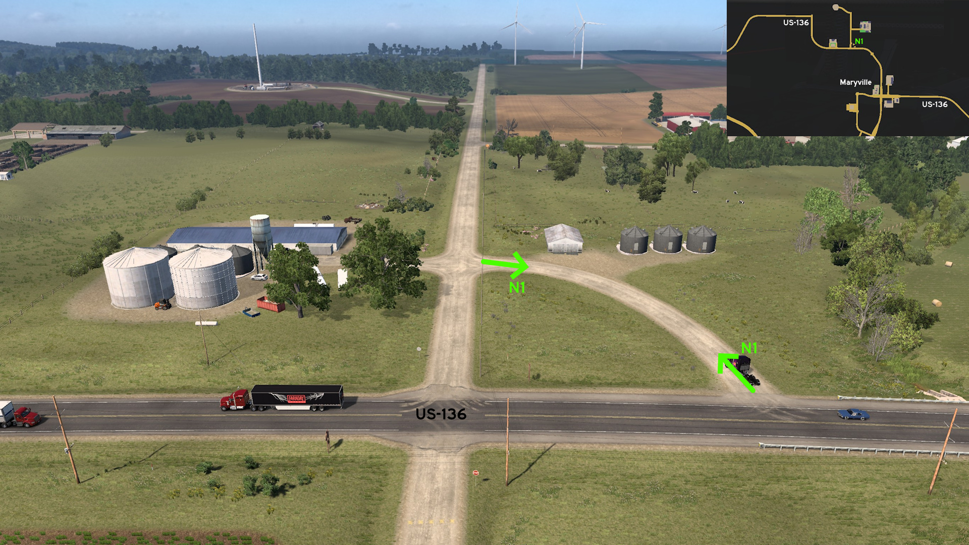 Head north Maryville, to the road to Vitas Power construction site and Golden Meadows farm. There's a loop on the northeast corner that can be used as a detour.
Poplar Bluff
Northwest 1 - Crooked Alternative
Category: shortcut, markableDiscovery: Epic Trucker Arch
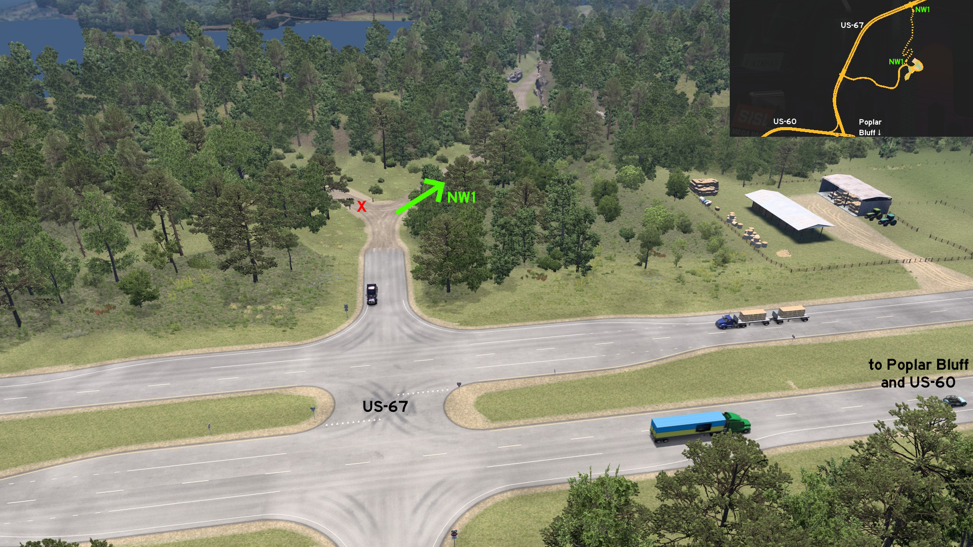 Leave northwest Poplar Bluff through US-67 and head to Chuck & Jack's logging area. Right after main entrance, another narrow and crooked path can be used to return to US-67 on north.
 Southwest 1 - Wood And Steel
Category: shortcut, markableDiscovery: Applecorn
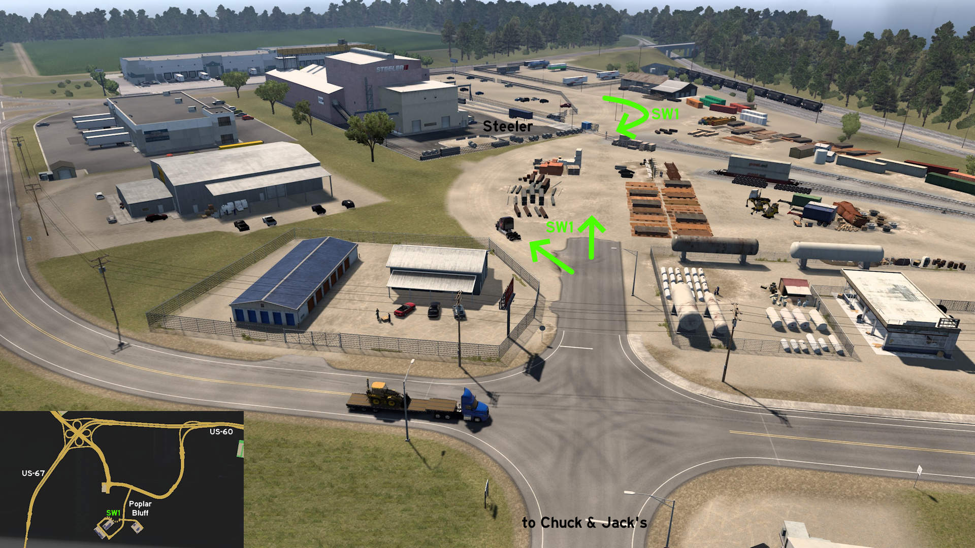 Head southwest Poplar Bluff. The road can be used to go from Steeler directly to Chuck & Jack's mill.
Rolla
East 1 - Beast Of Burden
Category: sceneryDiscovery: Applecorn
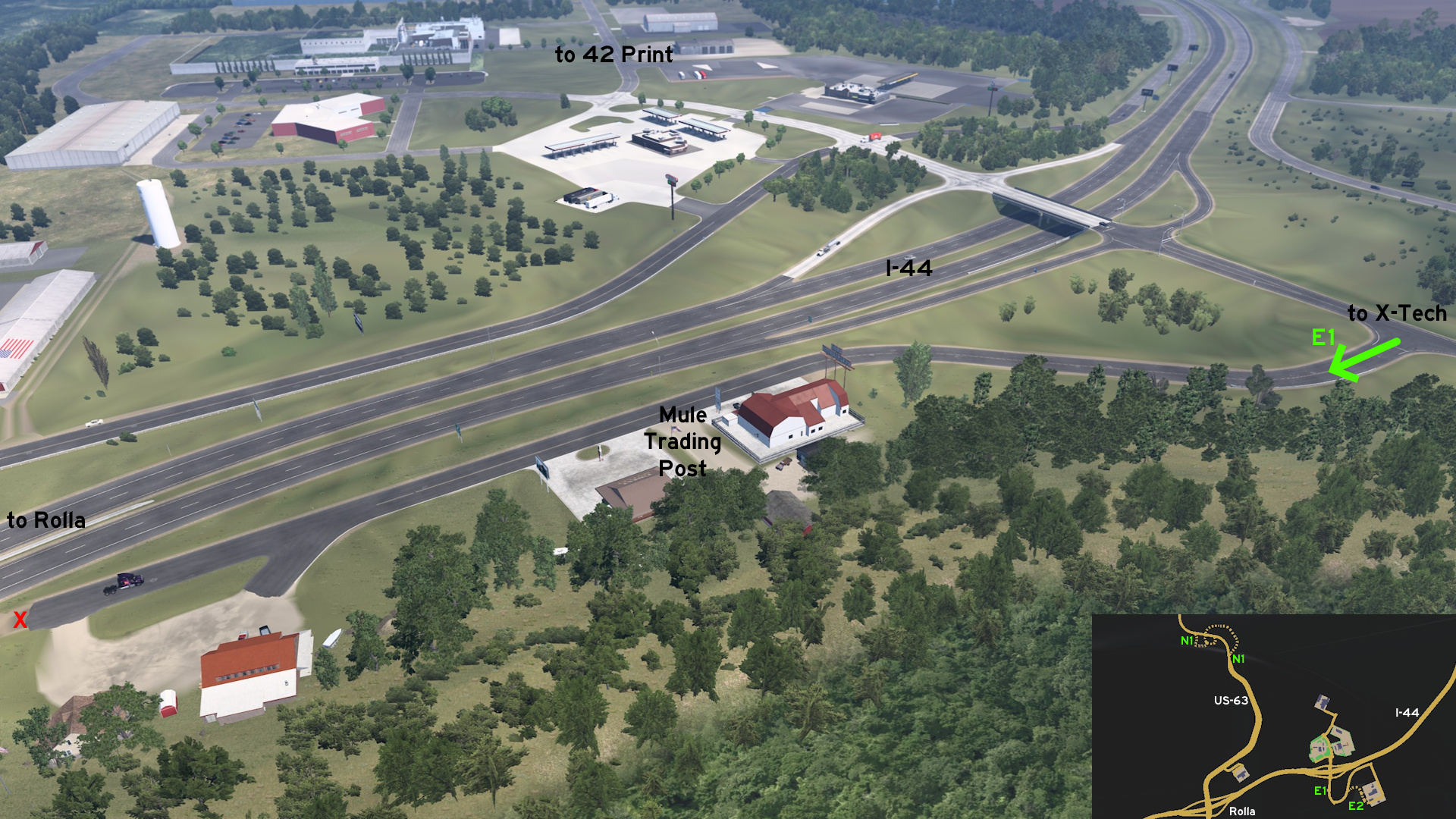 Leave east Rolla through I-44. Take the exit to X-Tech Machinery. Some meters after the ramp, take the east road to Mule Trading Post. You can drive as far as the road goes.
 East 2 - Crash Course
Category: shortcut, markableDiscovery: Applecorn
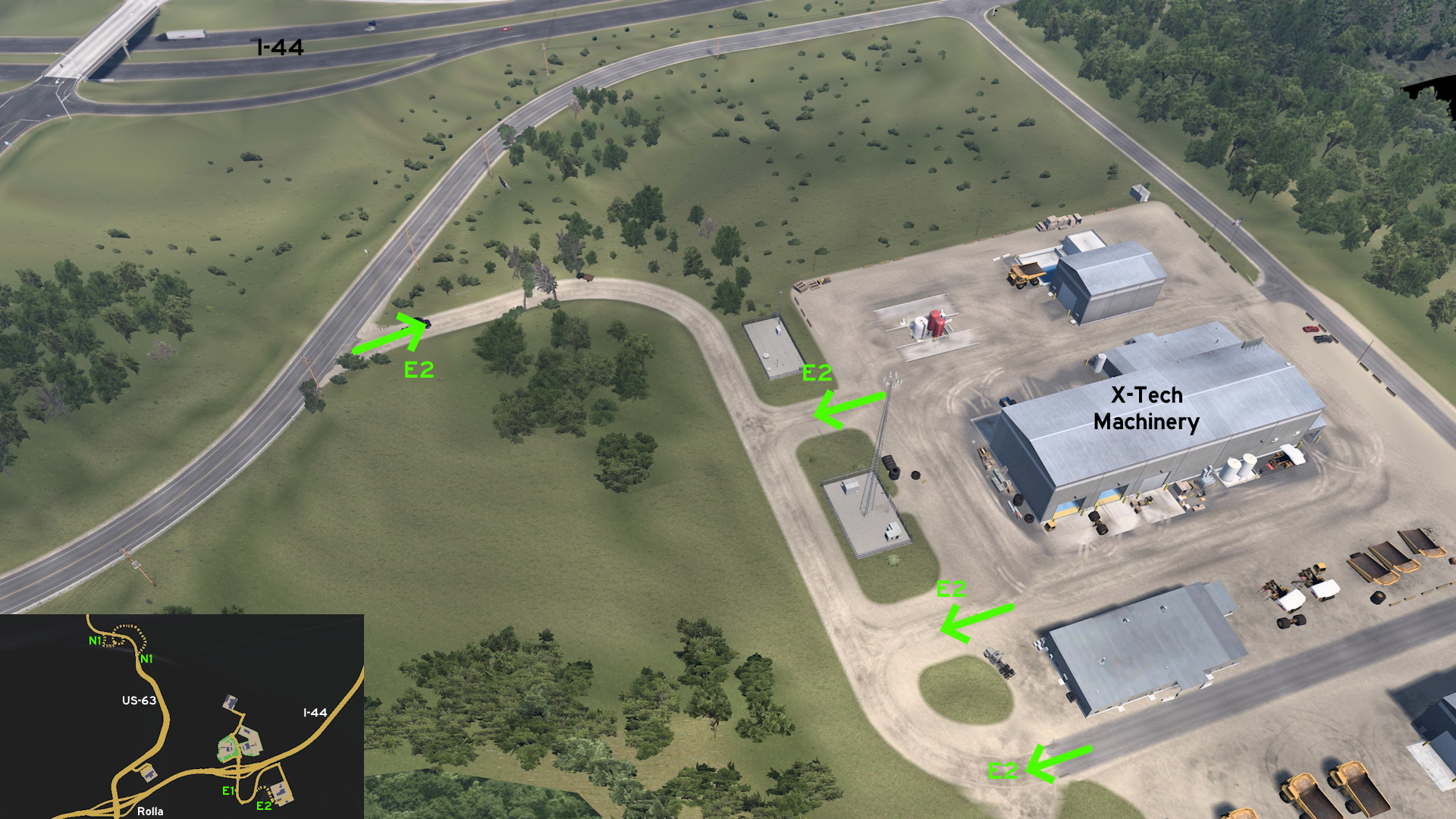 Leave east Rolla through I-44. Take the exit to X-Tech Machinery. Instead of following the marked route until the end, take the rough road halfway. Drive carefully to avoid crashing into tree limbs scattered all over the road and having the same fate of another fellow trucker.
 North 1 - Nature And Wild Life
Category: scenery, markableDiscovery: Applecorn
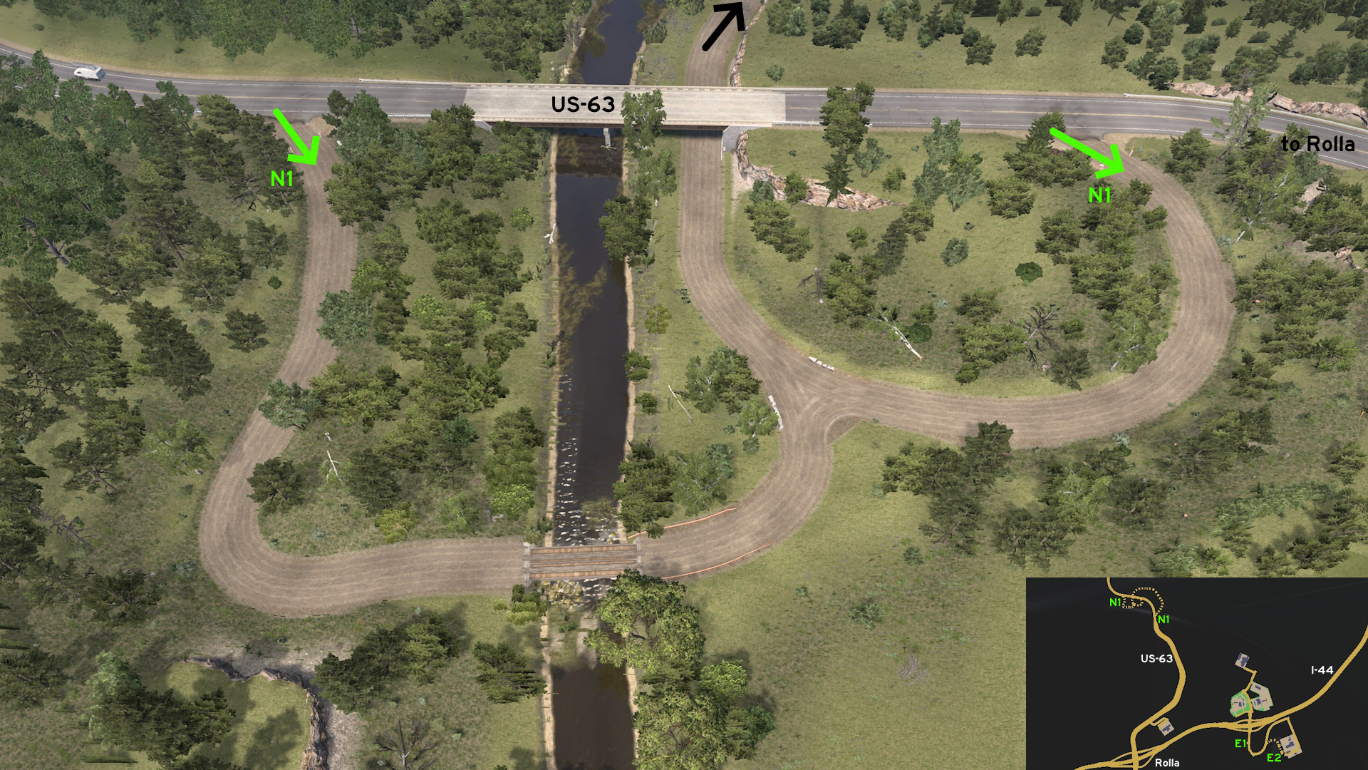 Leave north Rolla through US-63. The highway shield on map shows the bridge location. You can reach the trail by either one access on east, or two on west side of road. The trail goes under the bridge along the river, where you can find some people enjoying the view and herons nearby. Drive carefully over the wooden bridge.
 South 1 - Watch For Momo
Category: easter-egg, markableDiscovery: Applecorn
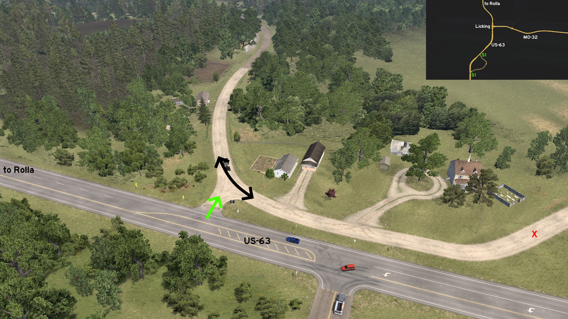 Leave south Rolla through US-63. Head south of MO-32 intersection, the unmarked town of Licking. The shield on map mark the first entrance. The other one is further ahead, where some houses, a pumpkin plantation and a graveyard is found. When crossing the bridge, watch for the mysterious cave on east.
 Southeast 1 - Nature And Literature
Category: achievement (Ozark Explorer), shortcut, markableDiscovery: Applecorn
Note: in order to unlock Ozark Explorer achievement, you need to find at least 12 viewpoints and watch the Director's Cut, and 2 are on hidden roads; please refer to this guide by Xeeran to find all 17 and other achievements
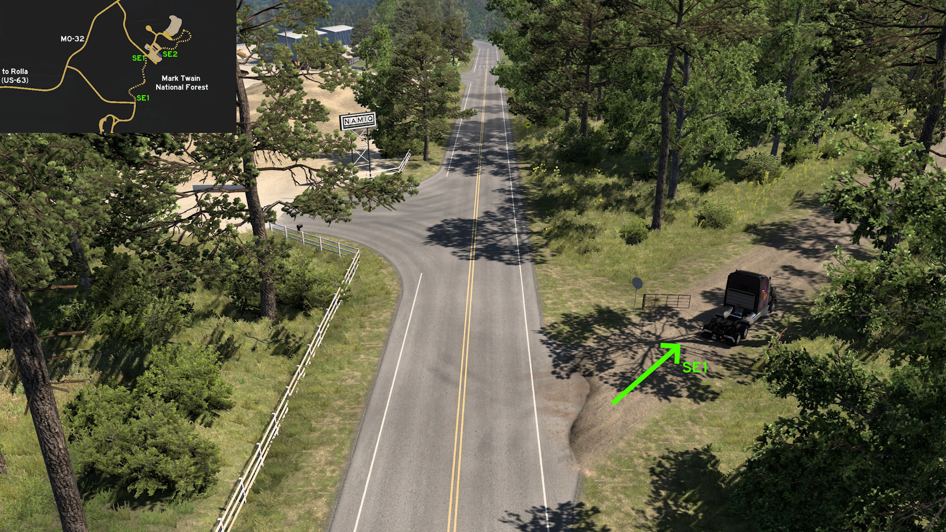 Leave south Rolla through US-63 and turn east on MO-32, on the unmarked town of Licking. Take the road to NAMIQ. Some meters before the first entrance, the road splits into a dirt road. Halfway you'll find Mark Twain National Forest viewpoint. Drive until the end, and you'll end up exactly on Chuck & Jack's logging area access.
 Southeast 2 - Avoiding The Sharp Corners
Category: shortcut, markableDiscovery: Applecorn
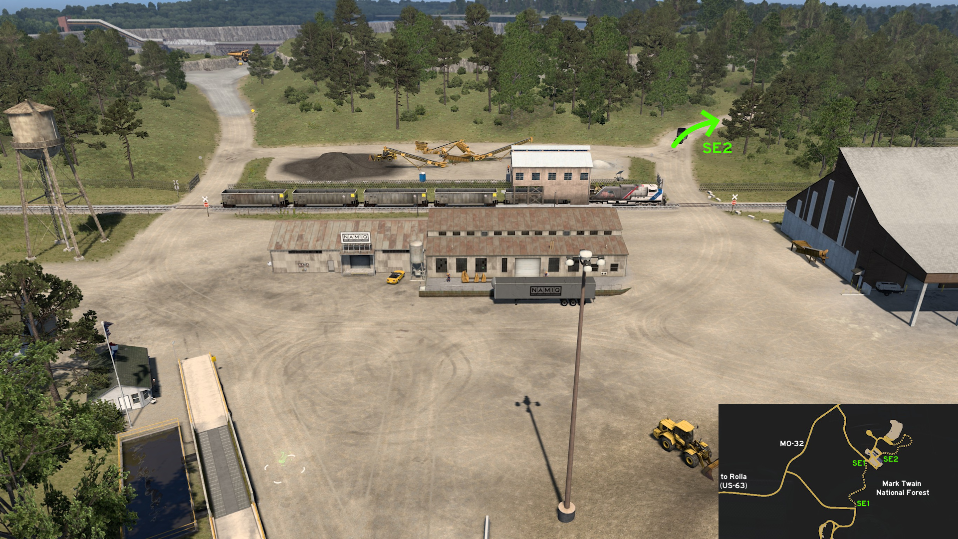 Leave south Rolla through US-63 and turn east on MO-32, on the unmarked town of Licking. Head to NAMIQ entrance. Instead of taking the marked route left, head right instead. You'll avoid some sharp corners, but be careful about crumbling rocks on alternative route.
Springfield
South 1 - Four Choices, One Easy Way Out
Category: shortcut, markableDiscovery: Applecorn
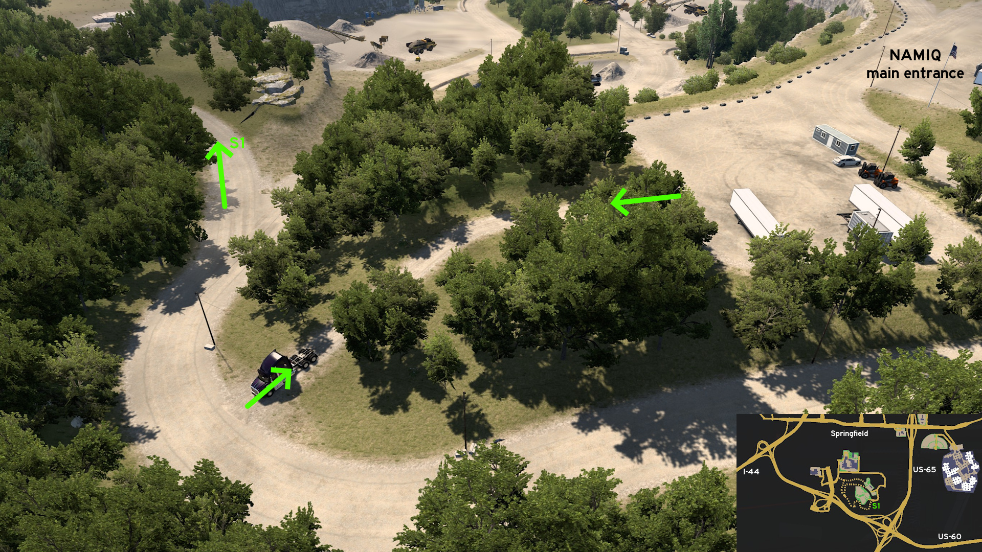 Head to NAMIQ mine south Springfield. From south of main entrance, there's an unmarkable path to the route leading to excavation area. Just some meters after it, instead of going deep, take the route southwest. It leads you both to the secondary entrance and back to main entrance.
 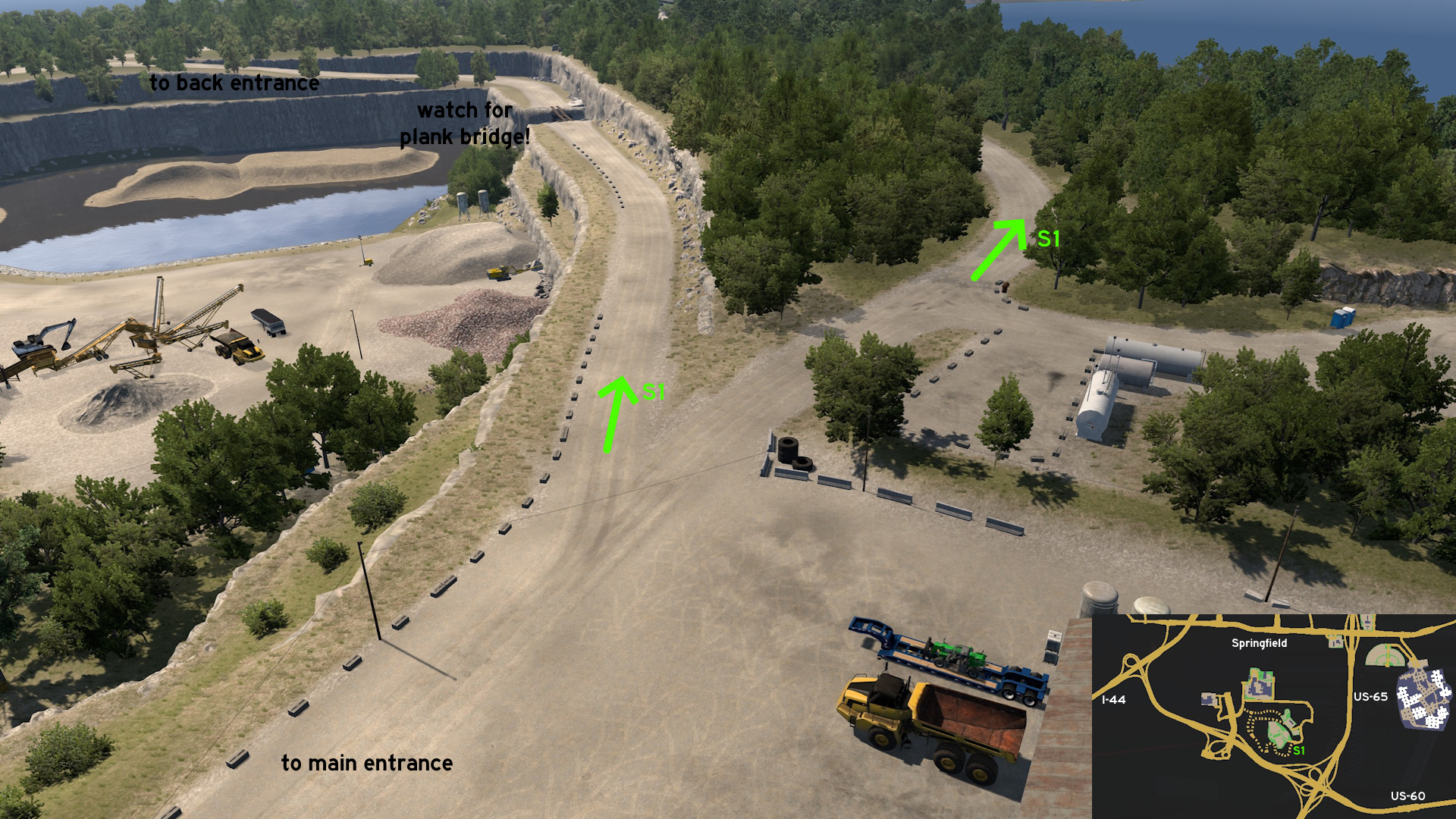 The previous route ends west of main entrance. Be careful when reaching the wooden bridge, make sure to keep your wheels well aligned to each plank. North of main entrance, you'll find the last route, which goes almost straight forward to the secondary entrance.
13th DLC, 2024 May 16
Alliance
Central 1 - Red Road To Rail Road
Category: shortcut, markableDiscovery: Half-man half-amazing
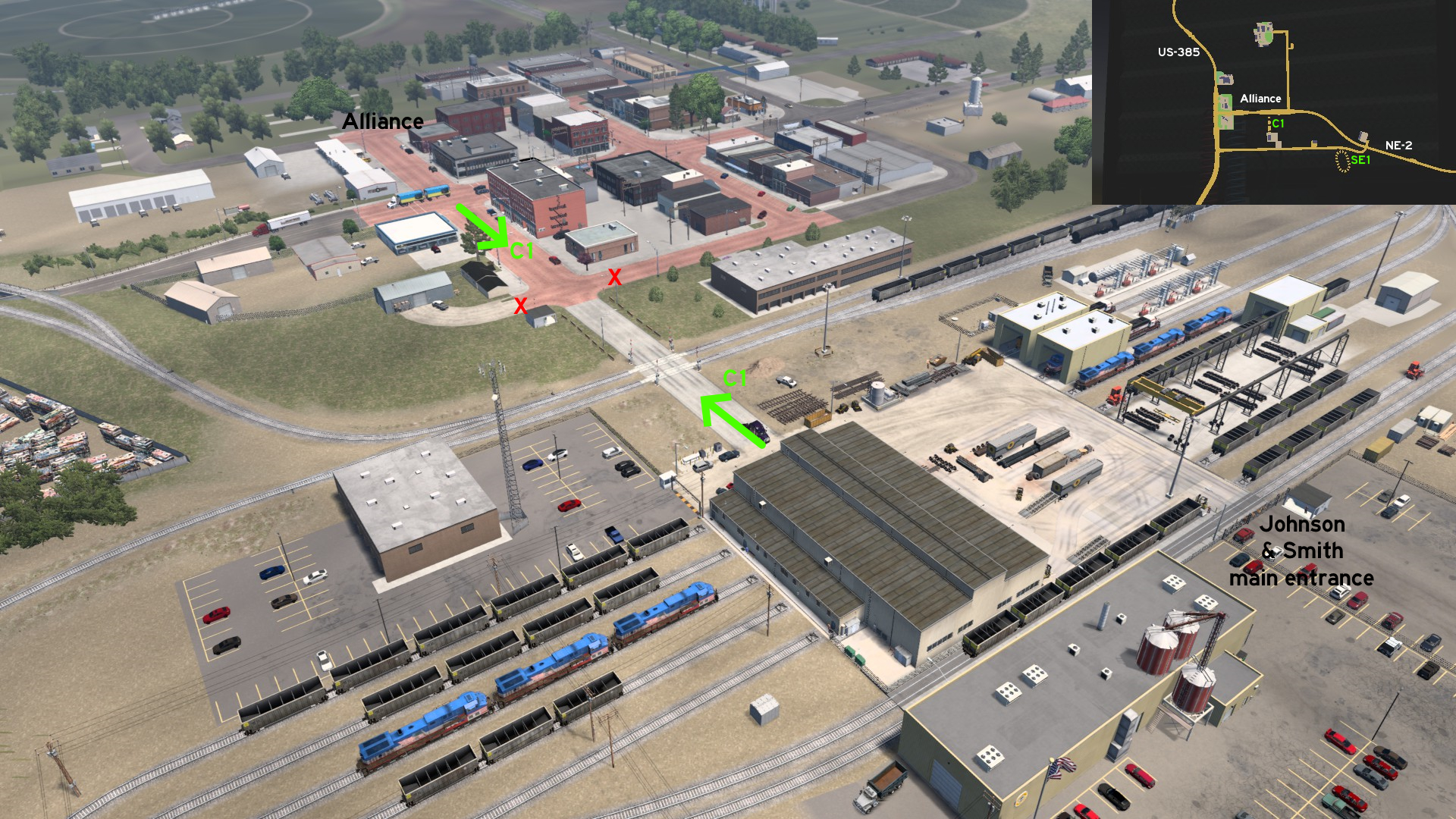 From the red brick roads on Alliance, go to the westernmost crossing and head south. It'll lead you to the back entrance of Johnson & Smith depot.
 Southeast 1 - Alliance Army Air Field
Category: scenery, markableDiscovery: Half-man half-amazing
Note: only the circle is markable
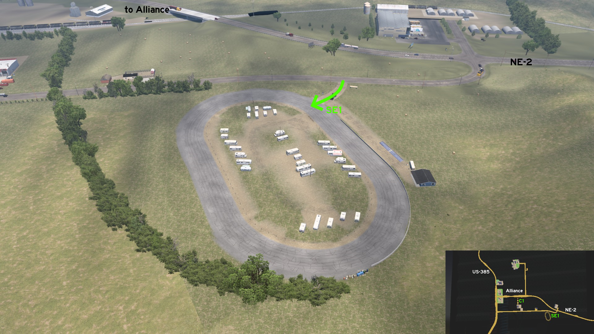 Across Equos Power depot, move some meters to find a small dirt path. You'll find a circle road with a trailer park inside, and marked by a historical sign about the Alliance Army Air Field.
Columbus
South 1 - Andrew Jackson Higgins National Memorial
Category: scenery, markableDiscovery: Jasper, Applecorn
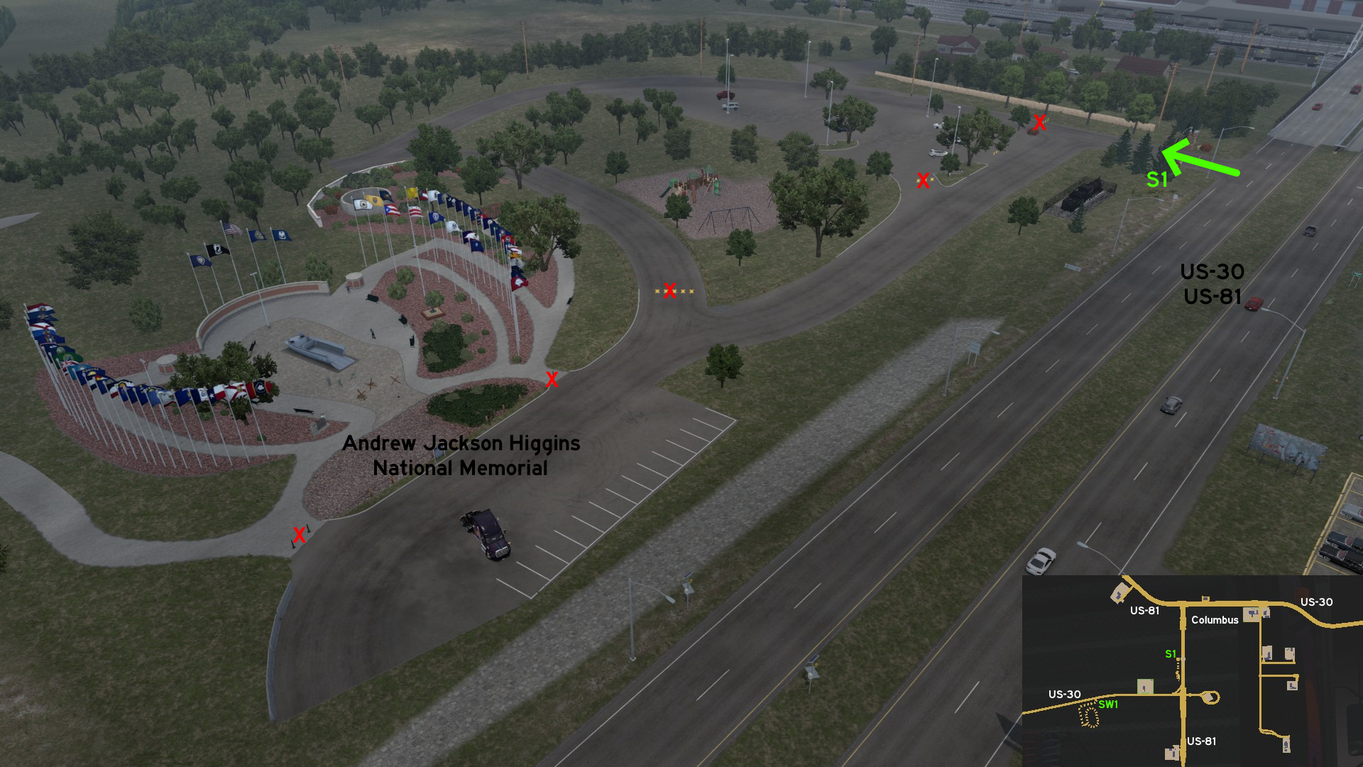 If just taking a picture of Andrew Jackson Higgins National Memorial from far away isn't enough, you can get a little closer to it. The entrance to the park is some meters north of the Photo Trophy target.
 Southwest 1 - Abe's US-30 Speedway
Category: scenery, markableDiscovery: Jasper
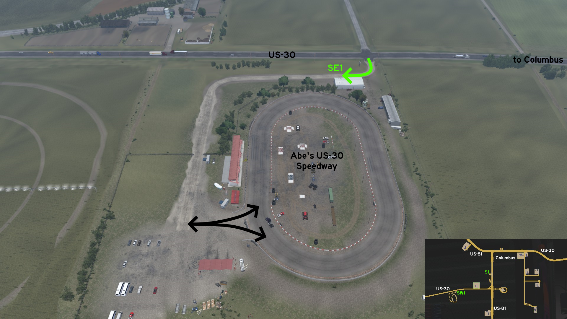 West of the rest stop out of Columbus, take the first road south to go to Abe's US-30 Speedway. The path go all around west of the circuit, and ends both on a parking lot and the circuit itself. You can also find several race cars, monster trucks and trailers inside the circuit.
Grand Island
North 1 - Parallel Lines
Category: shortcut, markableDiscovery: OWLCAT
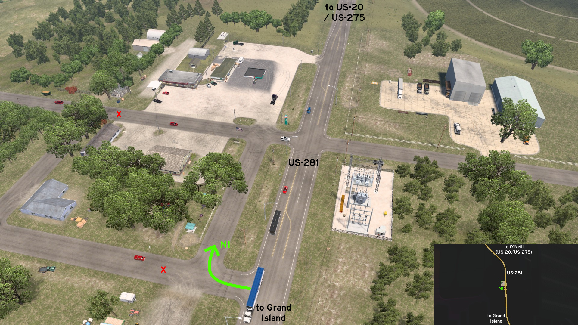 Between Grand Island and the unmarked town of O'Neill (intersection of US-20, US-275, US-281), there's an alternative entrance to the service station, right across a power substation.
 Southeast 1 - Through The Alley
Category: shortcutDiscovery: Applecorn
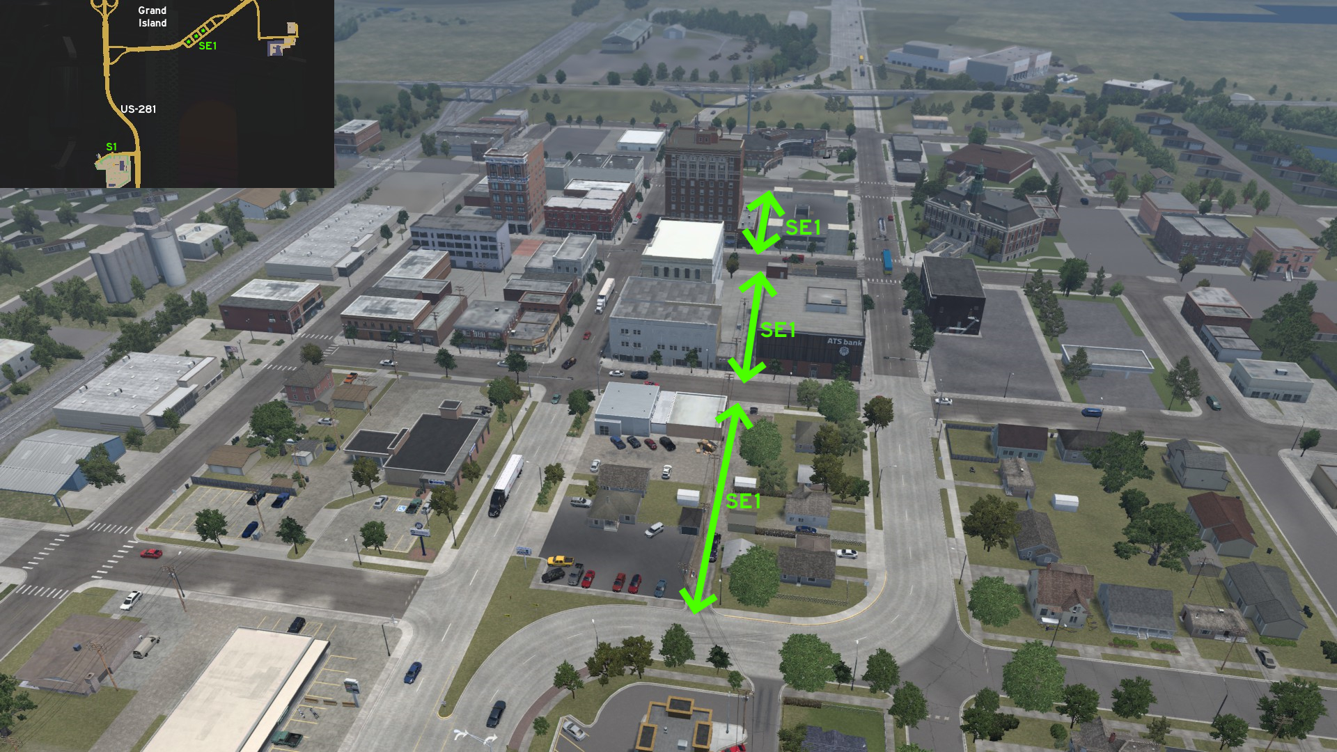 Where US-30 reaches Grand Island and splits into 1st and 2nd Streets, you can also drive through the alley between them. Just make sure the cargo isn't too wide, and cross the main streets carefully.
Lincoln 🏛️
Southeast 1 - Quick Rest On Auburn
Category: shortcut, markableDiscovery: OWLCAT, Applecorn
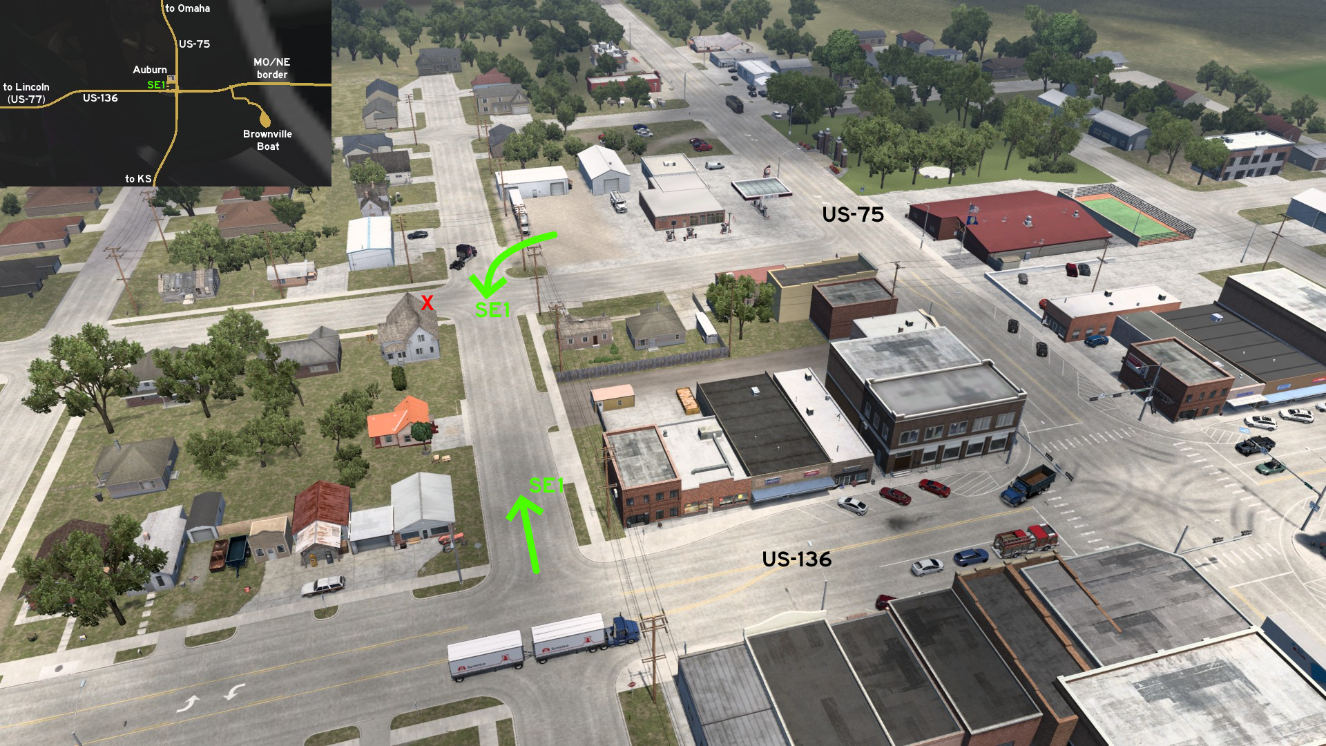 On the unmarked town of Auburn, some miles from the Director's Cut of Brownville Boar and the border of Missouri, there's a small service station on US-75 that can be quickly accessed by a street crossing US-136.
Norfolk
West 1 - Farming Shortcut
Category: shortcut, markableDiscovery: Applecorn, OWLCAT
Note: only the dusty shortcut is markable
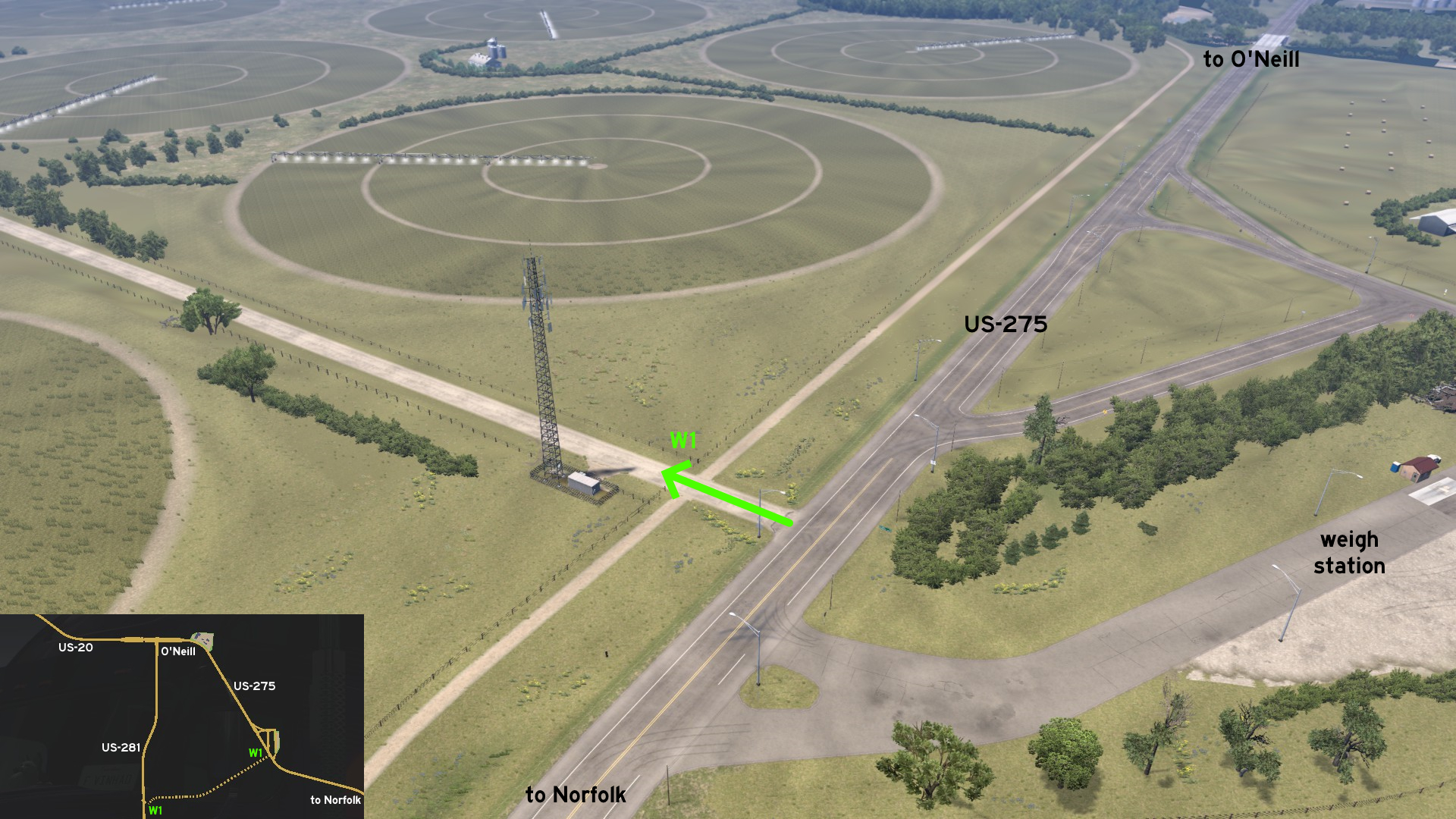 Starting on the weigh station west of Norfolk, on US-275, there's a dusty road going through the farm lands.
 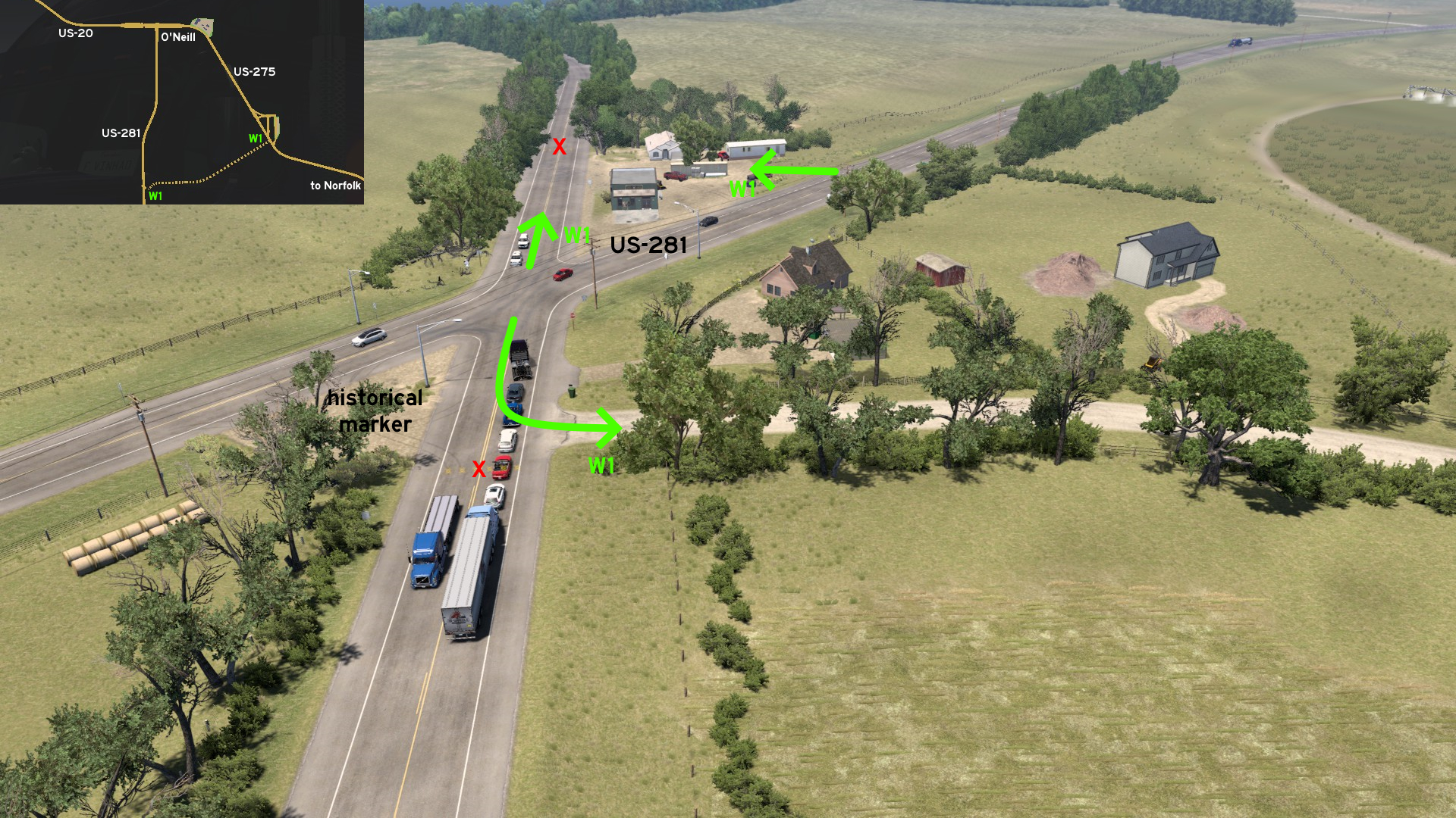 It ends on an asphalt road, which crosses US-281, south of the unmarked town of O'Neill. This diagonal crossing also features a historical mark about the road, and a small parking lot that can be used as a detour on the opposite side.
North Platte
North 1 - Thedford And Its Loops
Category: sceneryDiscovery: Applecorn
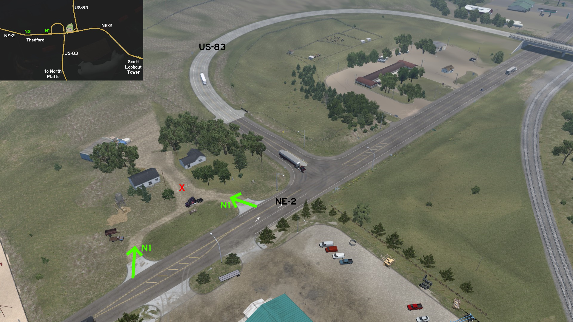 North of North Platte, on the unmarked town of Thedford, the westbound side of NE-2 is filled with loops. The official one is the junction of the route with US-83. The first unmarked one is a small property very close to it.
 North 2 - Thedford And Another Loop
Category: sceneryDiscovery: Applecorn
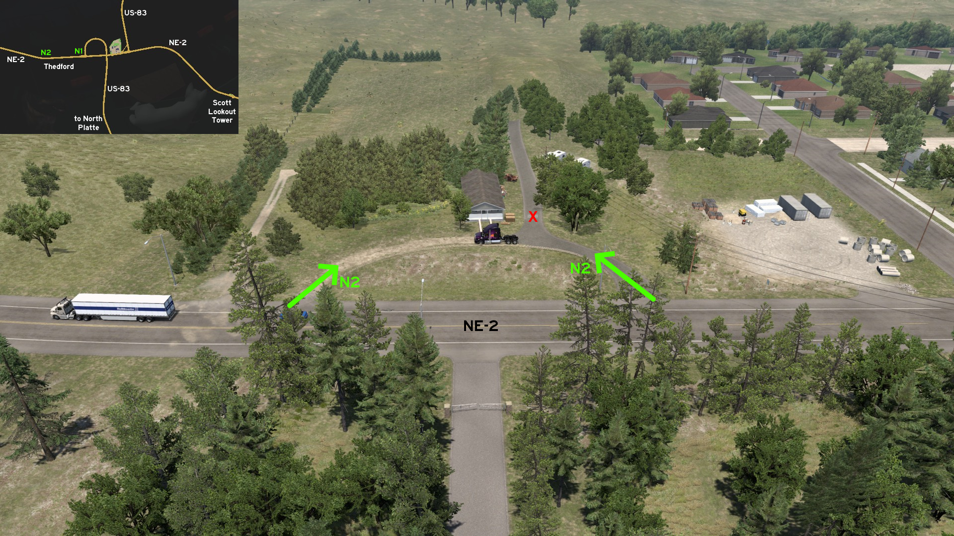 The second unmarked one is on the west end of Thedford, near another property that seems to be under construction.
 Northeast 1 - Just A Little Off Grid
Category: sceneryDiscovery: Applecorn
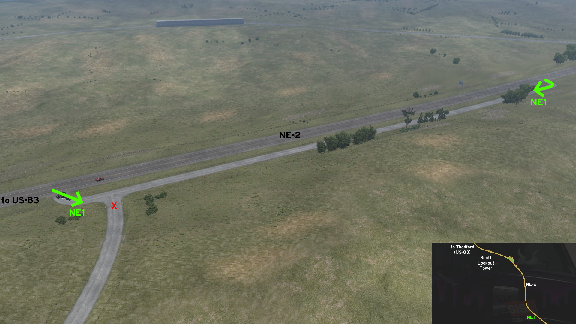 Northeast of North Platte, or more precisely southeast of the unmarked town of Thedford, the junction of NE-2 and US-83, the Director's Cut for Scott Lookout Tower and a small truck stop, there's a long gravel path running along NE-2.
 Southeast 1 - A Quiet Place To Rest
Category: scenery, markableDiscovery: Applecorn, OWLCAT
Note 1: only the rest area is markable, not the path to it
Note 2: even if the rest area icon doesn't appear, it still can be used as such
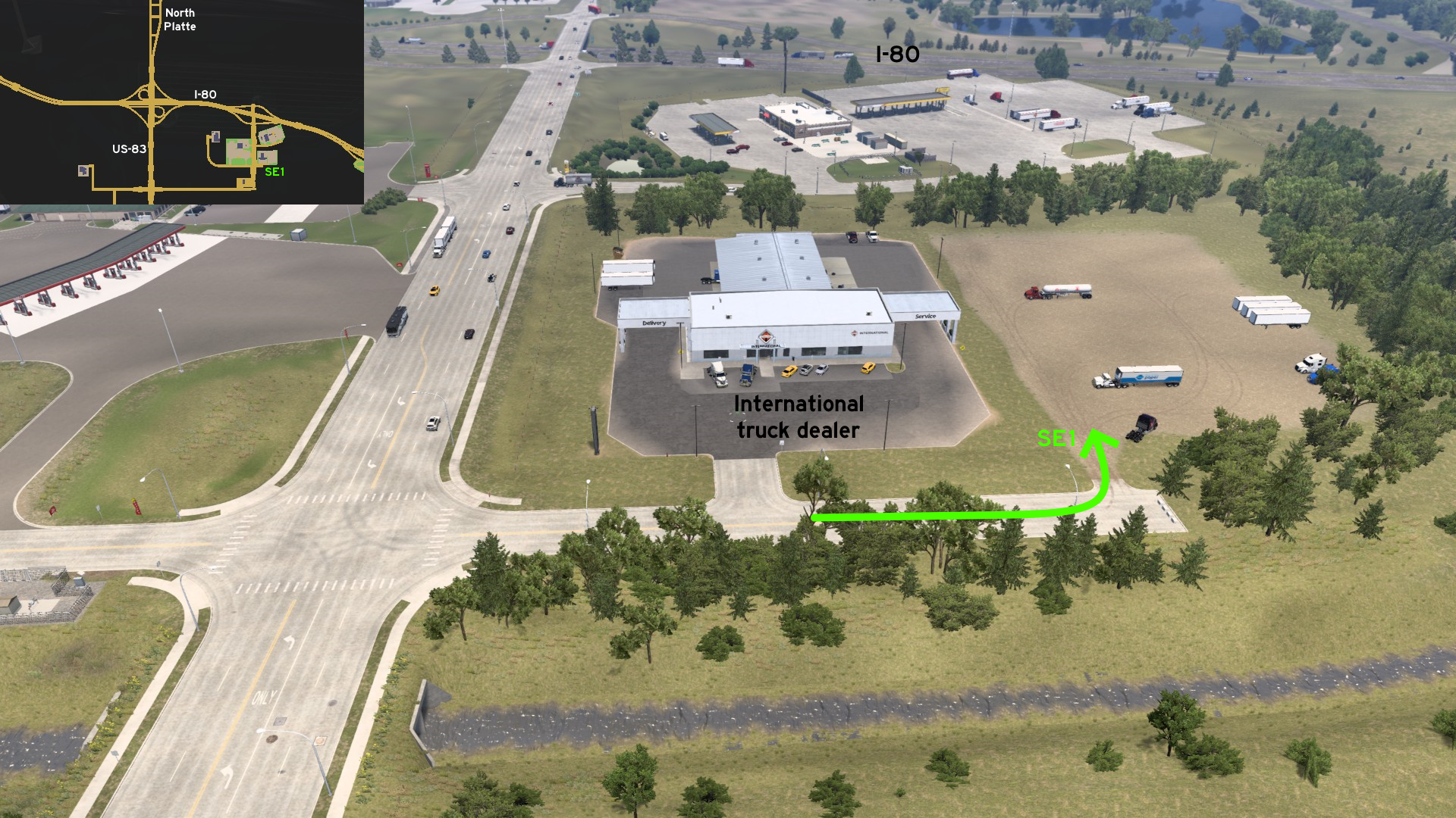 East of the International truck dealer of North Platte, there's a small empty terrain which can be used as a rest area. It doesn't seem to be much, but it's an alternative for all the busy areas around.
Omaha
Southwest 1 - Checking Fuel Prices Closer
Category: sceneryDiscovery: Applecorn
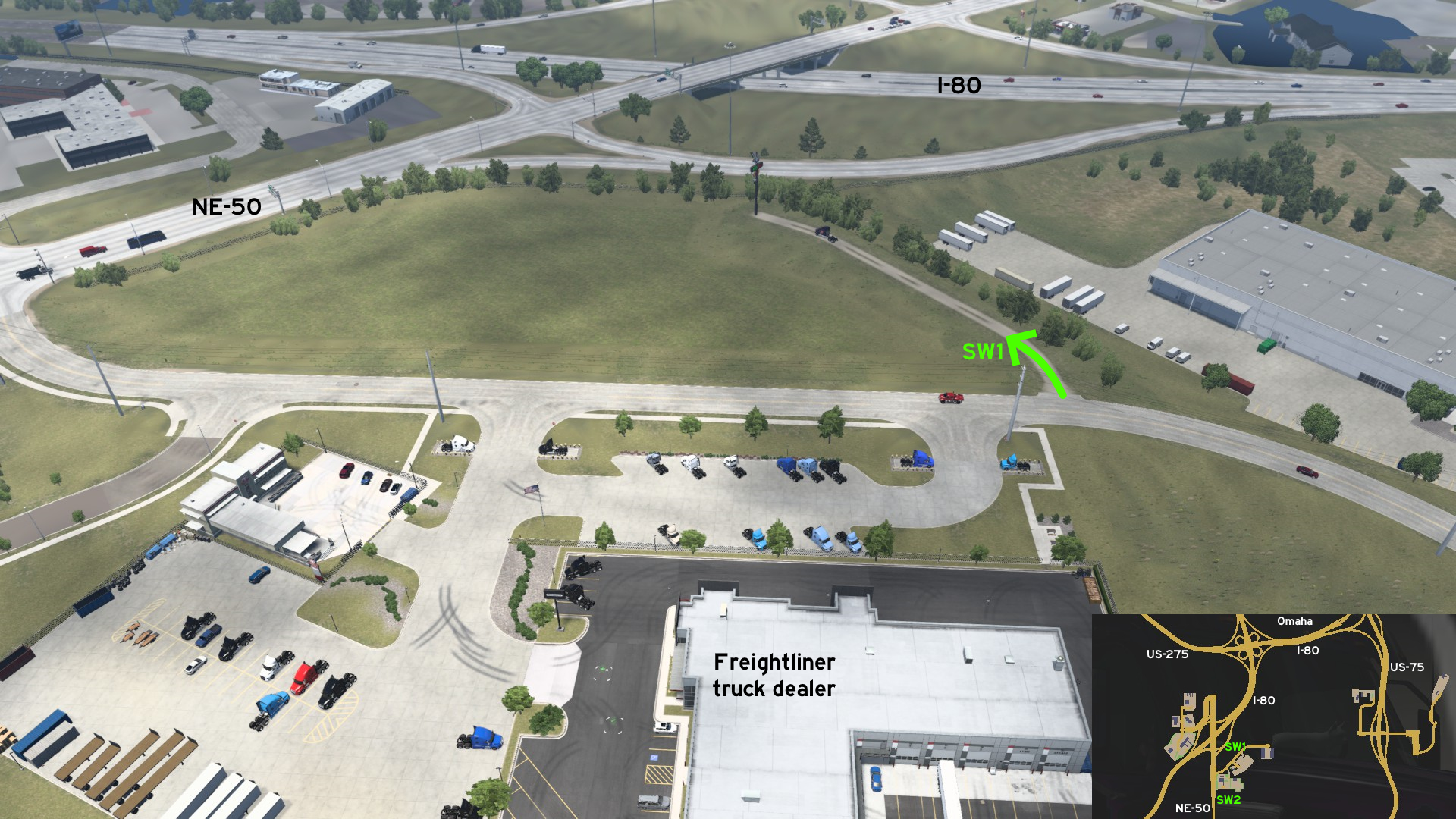 On the road leading to the Freightliner truck dealer of Omaha, there's a small service path connecting the main road to the fuel price sign for the nearby truck stop, placed near the exit ramp of I-80 to NE-50.
 Southwest 2 - Narrow Parallel Lines
Category: sceneryDiscovery: Applecorn, kaia15
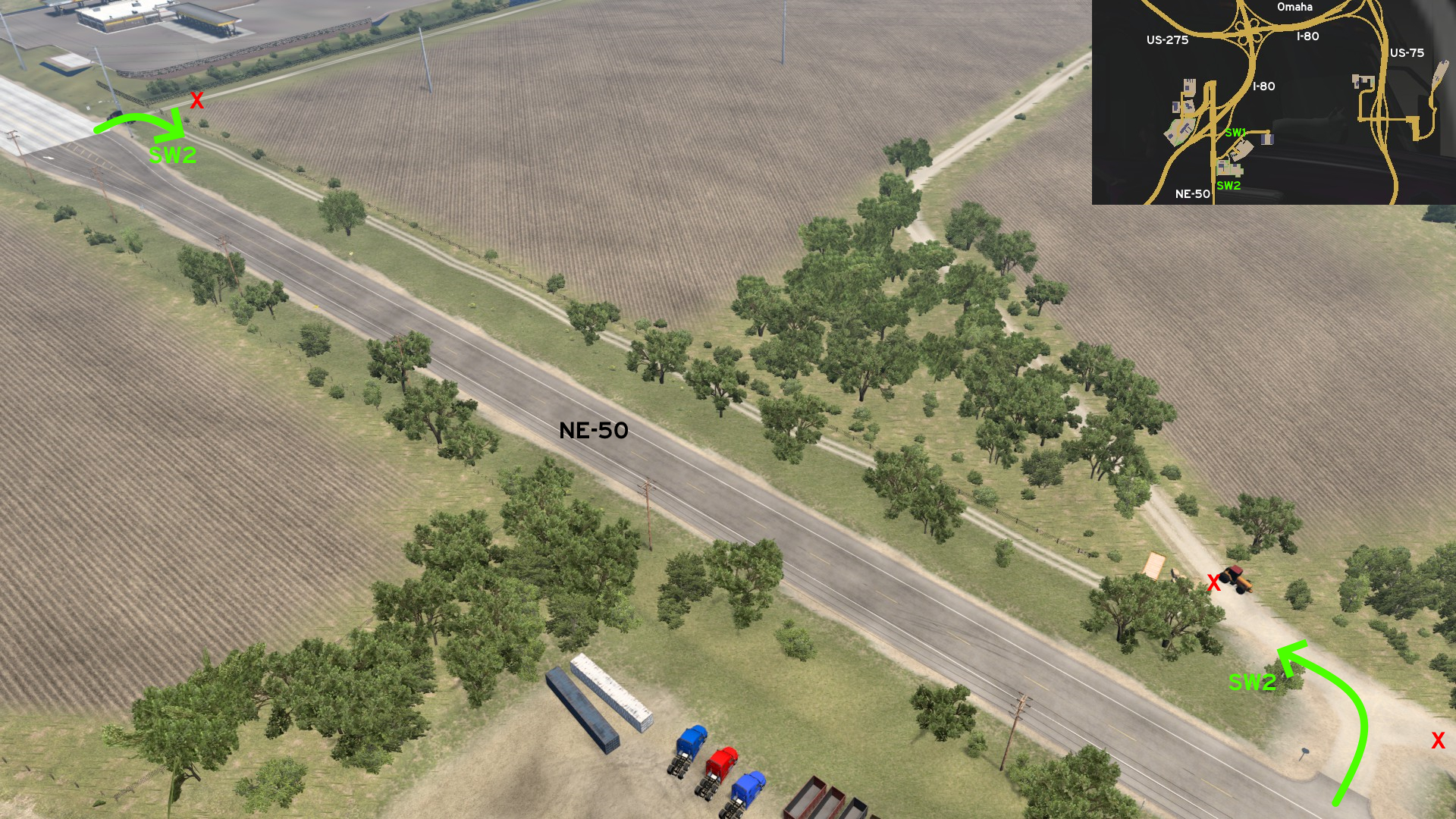 There's a narrow service path running along northbound NE-50. On GPS, it begins where the NE-50 shield is placed. When driving, it begins where the bridge ends. The path to the farm is blocked by a tractor and a hay pile. The path continues until NE-50 splits from two to four lanes, the powerlines start, and you're getting closer to the truck stop.
Scottsbluff
Central 1 - From The Meadows To The City
Category: shortcutDiscovery: Applecorn
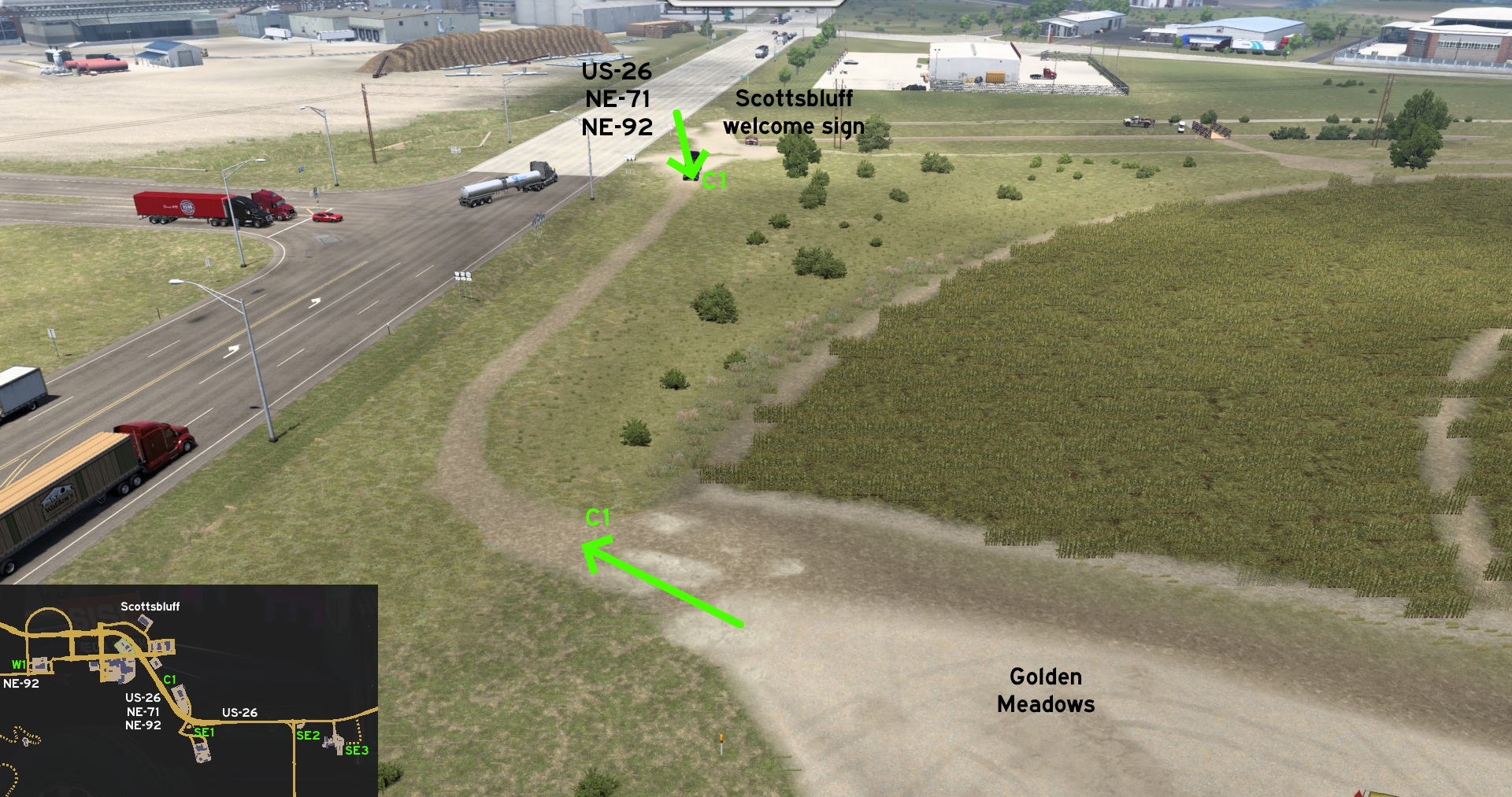 You can go directly from Golden Meadows farm to Scottsbluff without taking the main roads. Just go northwest of the property, and follow the makeshift path until you reach the city welcome sign, where routes US-26, NE-71 and NE-92 run along each other.
 Northwest 1 - Sunset Memorial Park
Category: sceneryDiscovery: Applecorn
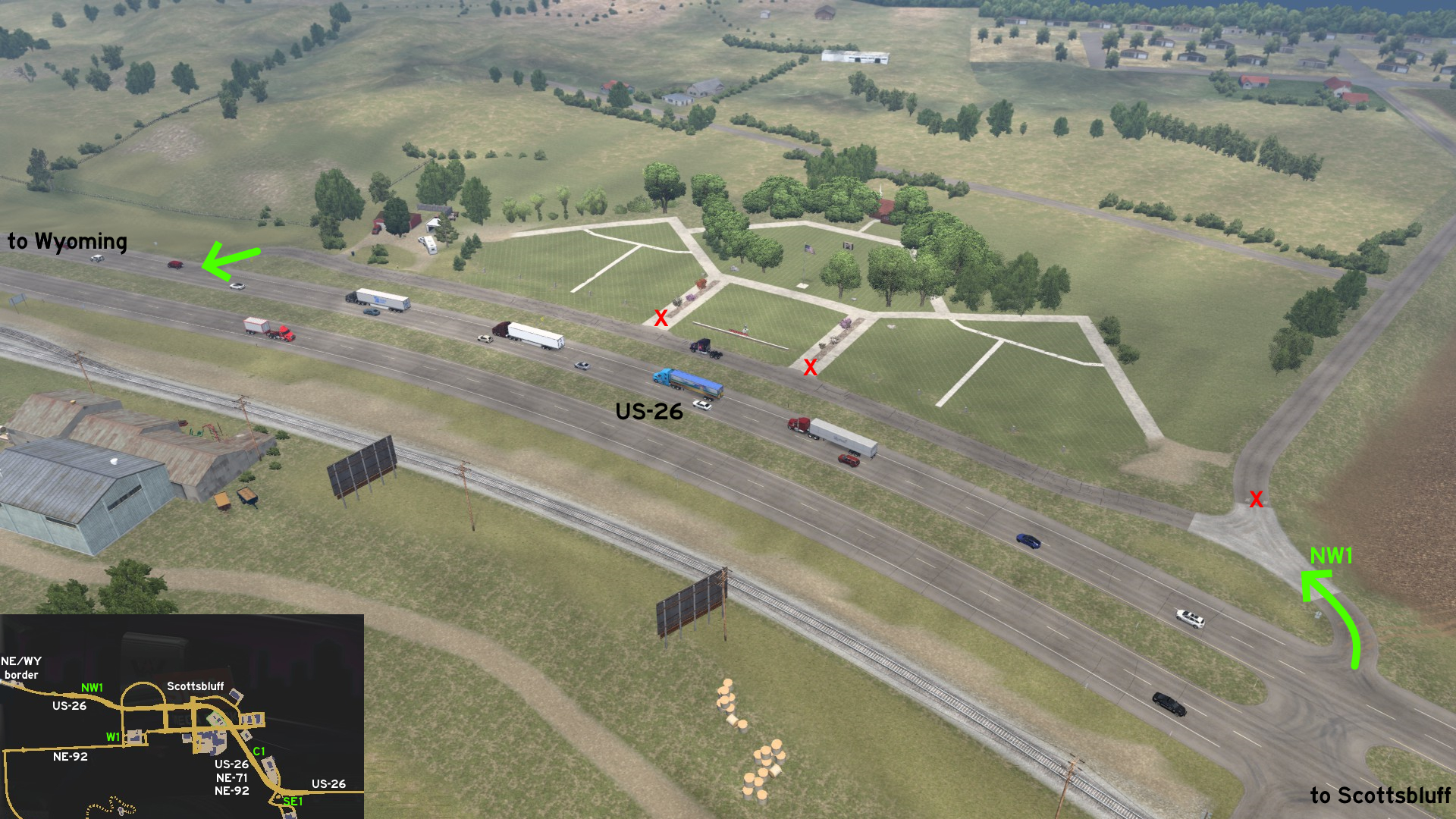 Leaving Scottsbluff and heading Wyoming, you can pay a visit to Sunset Memorial Park. On GPS, its entrance is close to where US-26 shield is placed. You can drive along the area, and return to the road close to where lanes merge.
 South 1 - Scotts Bluff National Monument And City Overlook
Category: scenery, markableDiscovery: Wide Kemo, OWLCAT, biromesyservilletas
Note: route may get discovered by accessing the Director's Cut viewpoint area
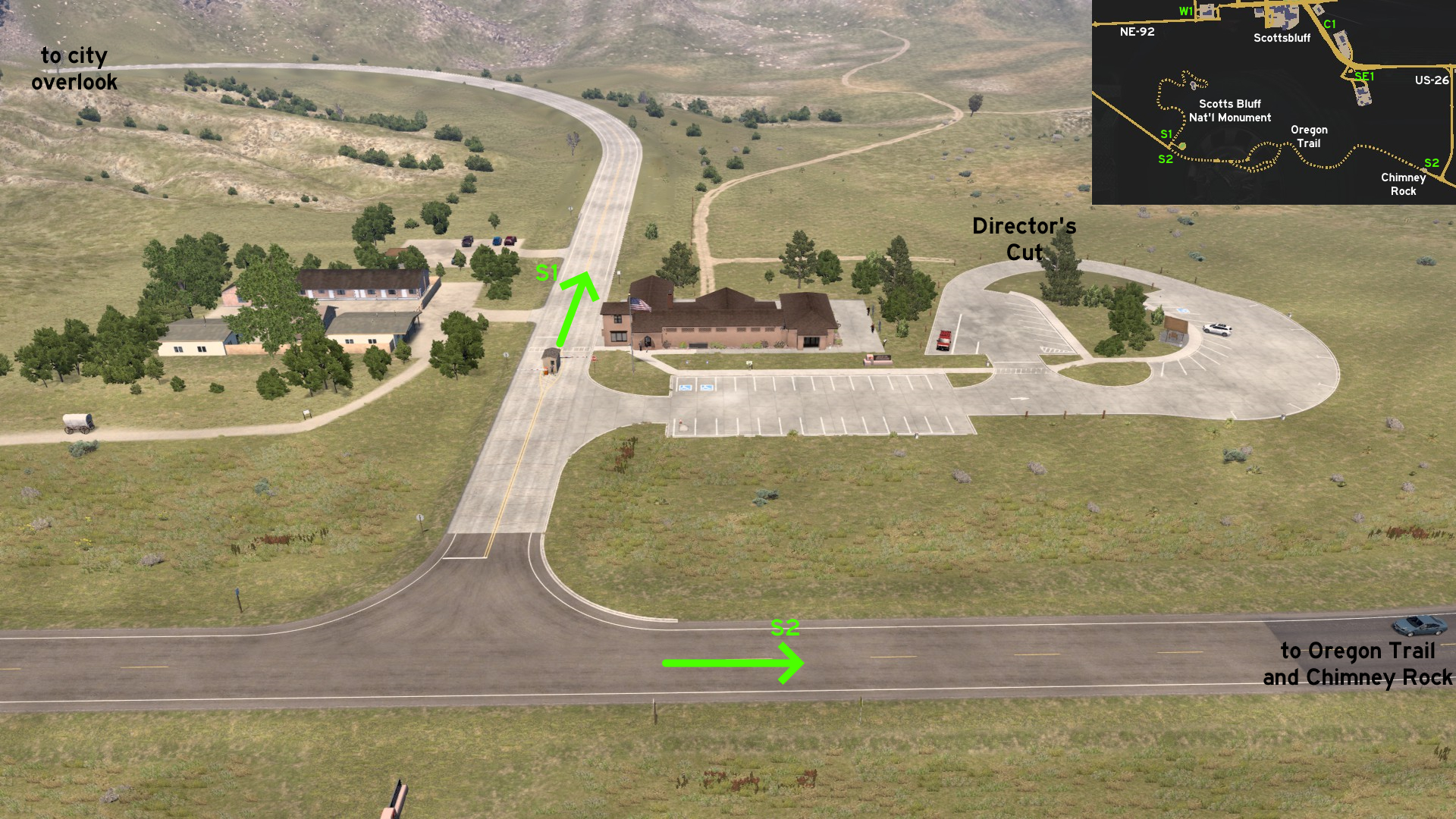 Coming west from NE-92, you can visit Scotts Bluff National Monument. Starting on visitor center, just cross the gates heading north to see the city from a vantage point. Leave the area again and head east to drive through the Oregon Trail.
 South 2 - Chimney Rock And Oregon Trail
Category: achievement (Nebraska Explorer), markableDiscovery: Wide Kemo, OWLCAT, biromesyservilletas
Note: in order to unlock this achievement, you need to find and watch 9 Director's Cuts, and only this one is hidden; please refer to this guide by Xeeran to find all 9 and other achievements
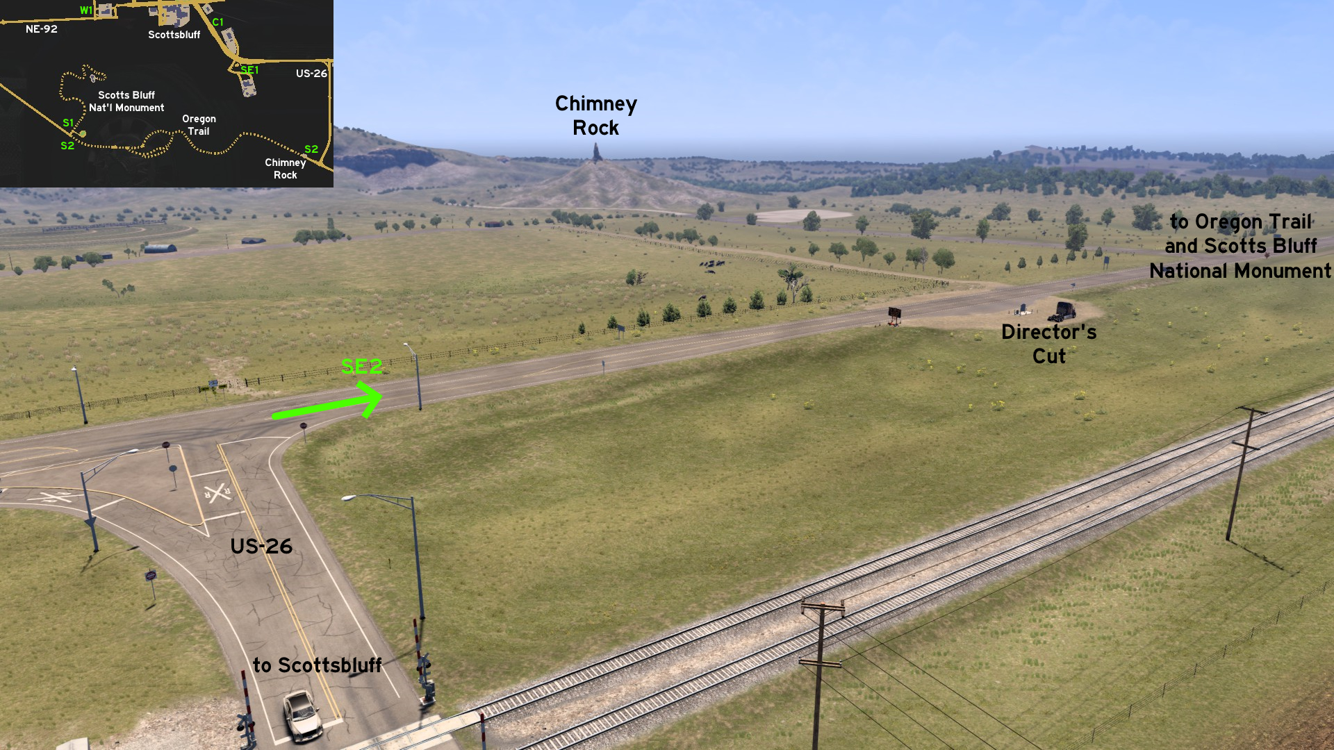 If you continue east from the National Monument, you'll reach an unfinished road. You'll need to take a detour through Oregon Trail, which splits into three different almost hidden paths, going through makeshift bridges and mining tunnels. Drive extremely careful there! When you return to the unfinished road, you can find the hidden Director's Cut for Chimney Rock.
 Southeast 1 - Rebecca Winters Memorial Park
Category: scenery, markableDiscovery: Applecorn, OWLCAT
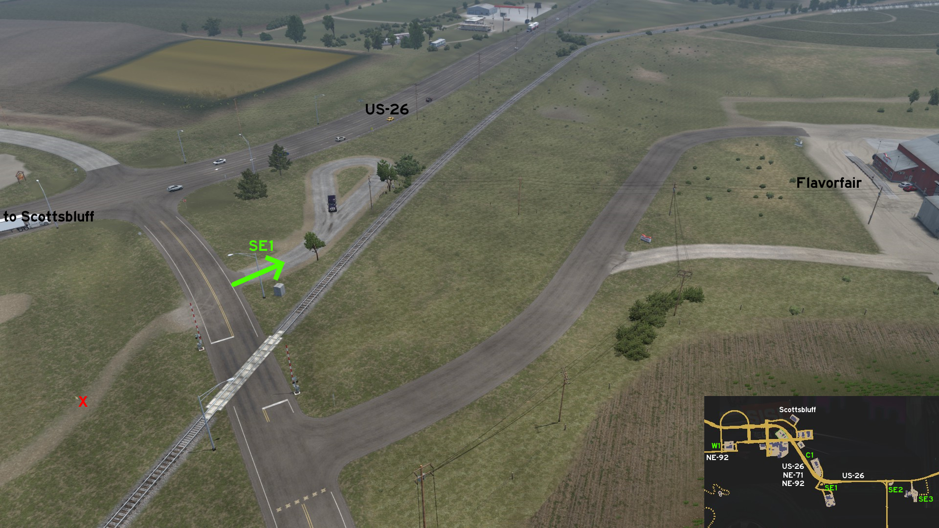 On the way to Flavorfair, between US-26 and the railroad, there's a lasso-shaped path. Close to the end of its curve, you can find Rebecca Winters' grave, along with historical information about the region.
 Southeast 2 - Just Enjoy The Surrounds
Category: scenery, markableDiscovery: Jasper
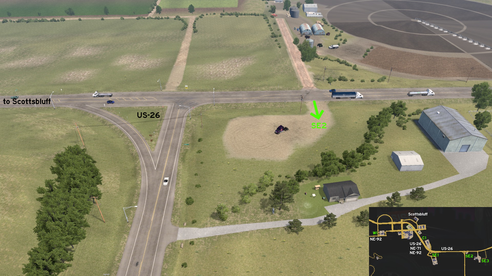 Between US-26 junction and Grand Pastures, there's an empty area where you can stop and enjoy the air... but can't stop to sleep here.
 Southeast 3 - Narrowing Path
Category: shortcut, markableDiscovery: Half-man half-amazing
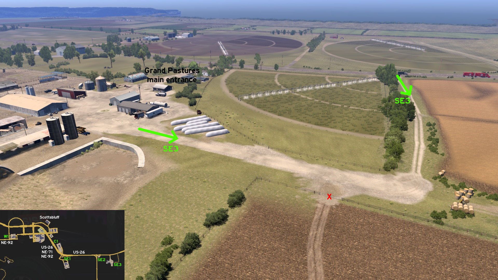 Heading east of Grand Pastures delivery area, you can find an alternative way to leave the area. Just be warned that the path gets narrower as it gets closer to the exit.
 West 1 - Two Easier Alternatives
Category: shortcut, markableDiscovery: Jasper, Cyanlix
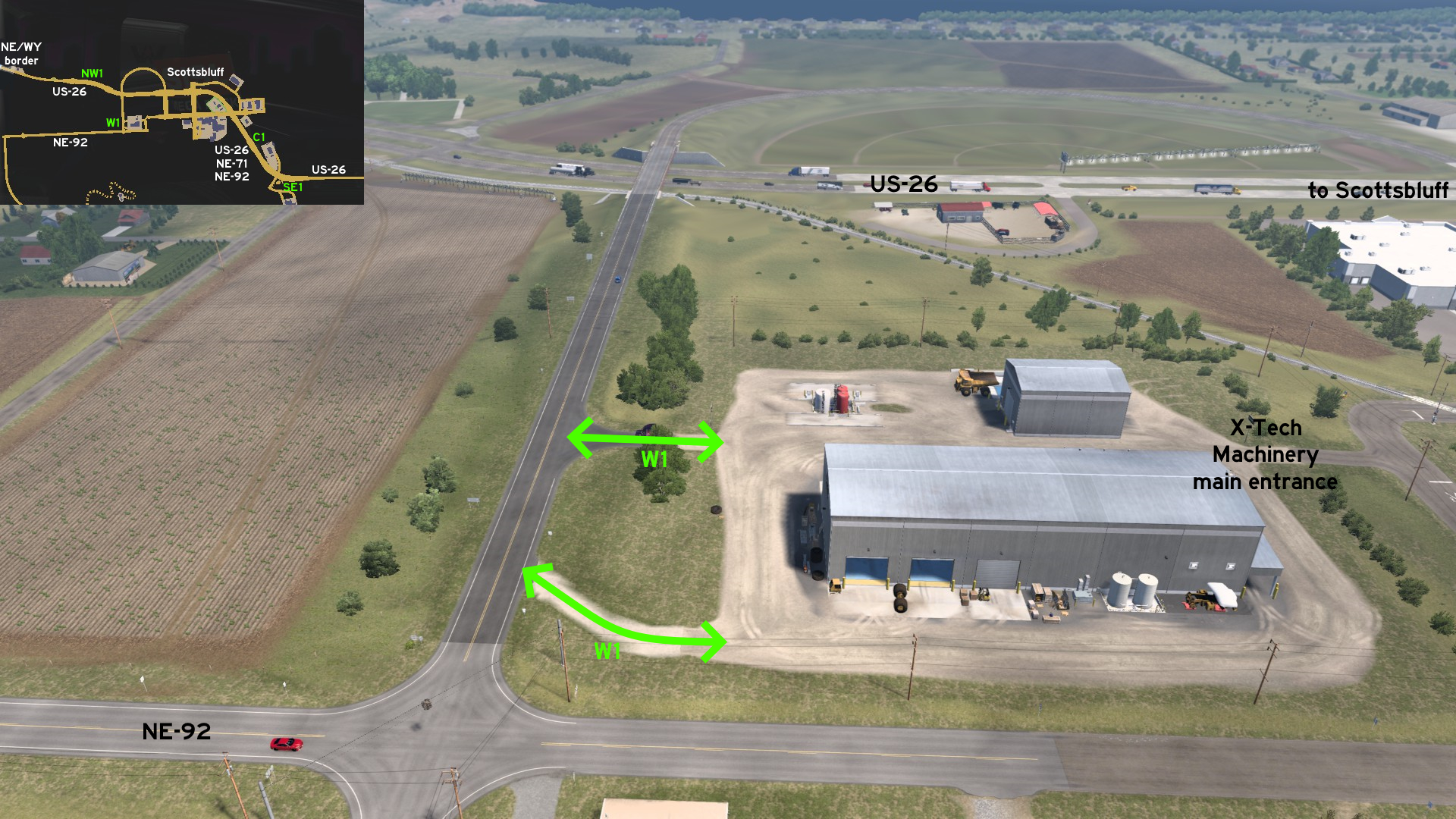 You can use the dusty paths back of X-Tech depot, to avoid the complicated and curved railroad crossing found at its main entrance.
Sidney
East 1 - Across Ash Hollow
Category: shortcut, markableDiscovery: Half-man half-amazing, Jasper, kaia15
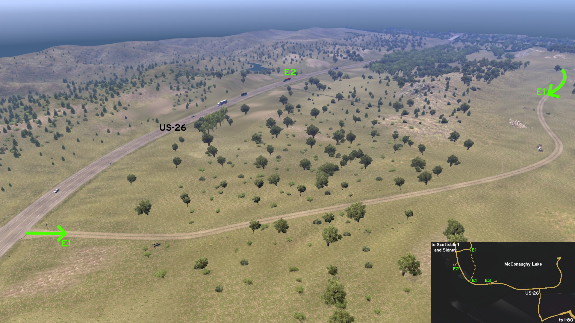 If you want a different perspective to Ash Hollow, leave the visitors center on the curve and head south to return to US-26.
 East 2 - Windlass Hill Pioneer Homestead
Category: scenery, markableDiscovery: Half-man half-amazing, Jasper, kaia15
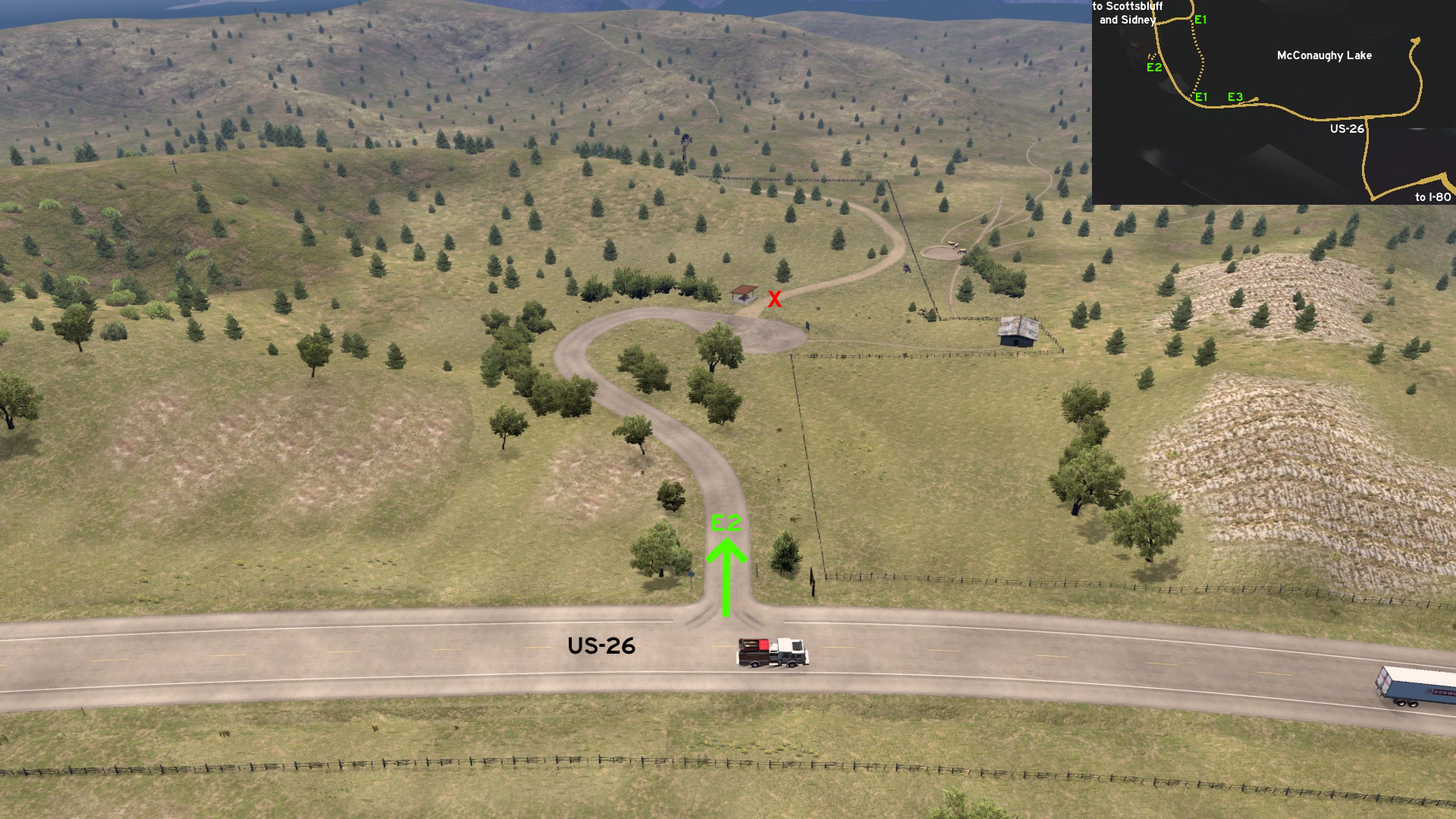 Between the official and the alternative accesses to Ash Hollow visitors center, and across US-26, you can also pay a visit to Windlass Hill Pioneer Homestead.
 East 3 - A Different Perspective To McConaughy Lake
Category: scenery, markableDiscovery: OWLCAT
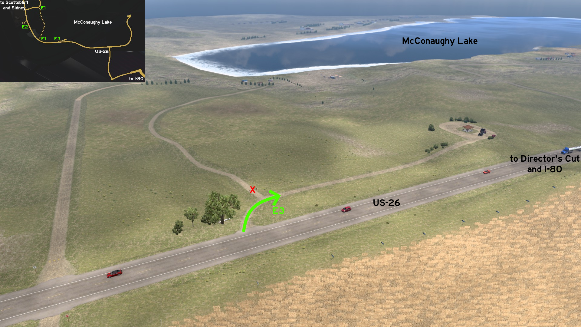 If you've already visited the Director's Cut for McConaughy Lake, you can also see the lake from south. The spot is some miles after Ash Hollow.
 Southeast 1 - Sleep Like A Rock
Category: shortcut, markableDiscovery: Half-man half-amazing
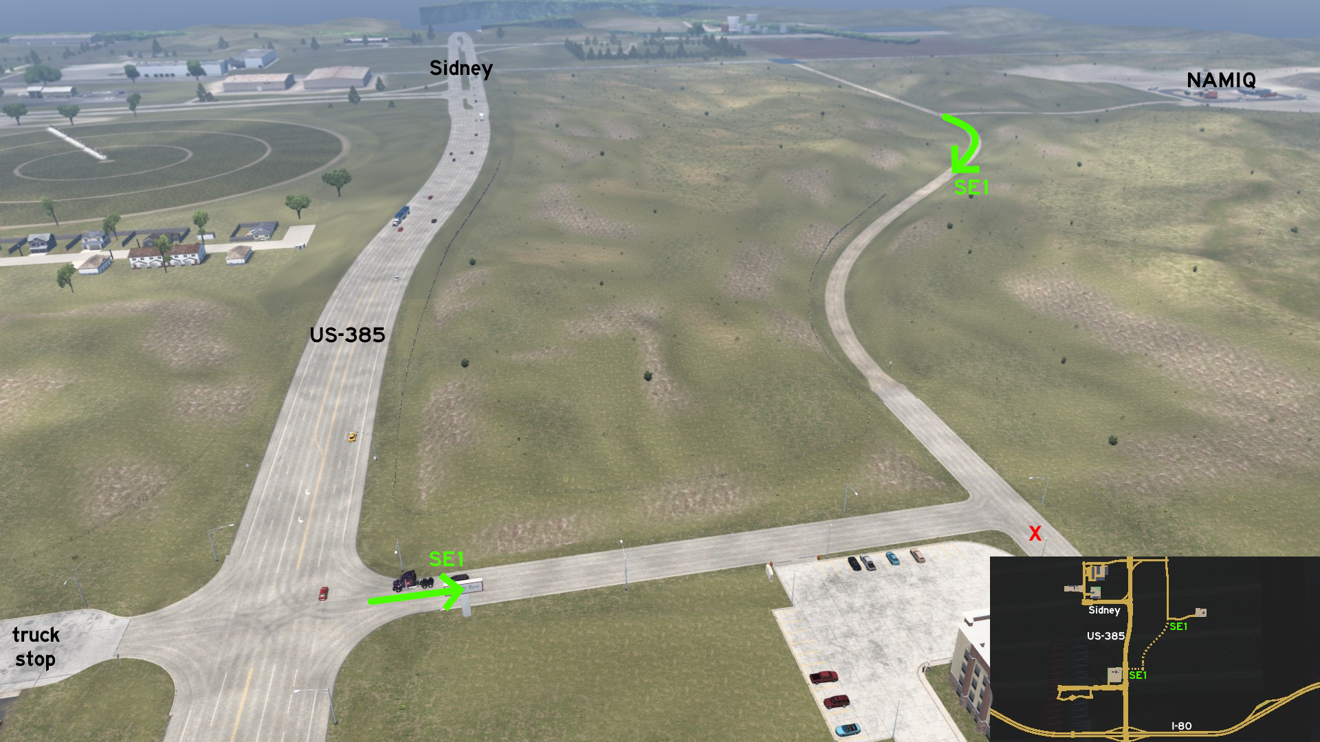 From NAMIQ mine on Sidney, head south, and you can return to US-385 direct to the truck stop near I-80, avoiding the traffic of the main roads.
 Southeast 2 - See Colorado From Here
Category: scenery, markableDiscovery: Zest
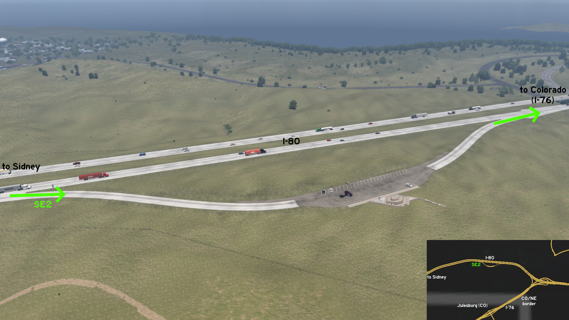 Leaving Sidney eastbound on I-80, there's a scenic view point before I-76 junction - but trucks aren't allowed here. Just stop quickly and look south, and you'll see Julesburg, Colorado, without having to leave Nebraska.
Valentine
Northeast 1 - From Pastures To Barn
Category: shortcut, markableDiscovery: Applecorn, OWLCAT
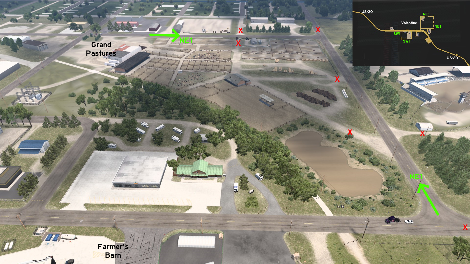 Leaving east of either Grand Pastures or Farmer's Barn on Valentine, you can find an alternative route between them. The GPS around Farmer's Barn almost hints something is really hidden there.
 Southwest 1 - Around The Service Station
Category: shortcut, markableDiscovery: Applecorn, OWLCAT
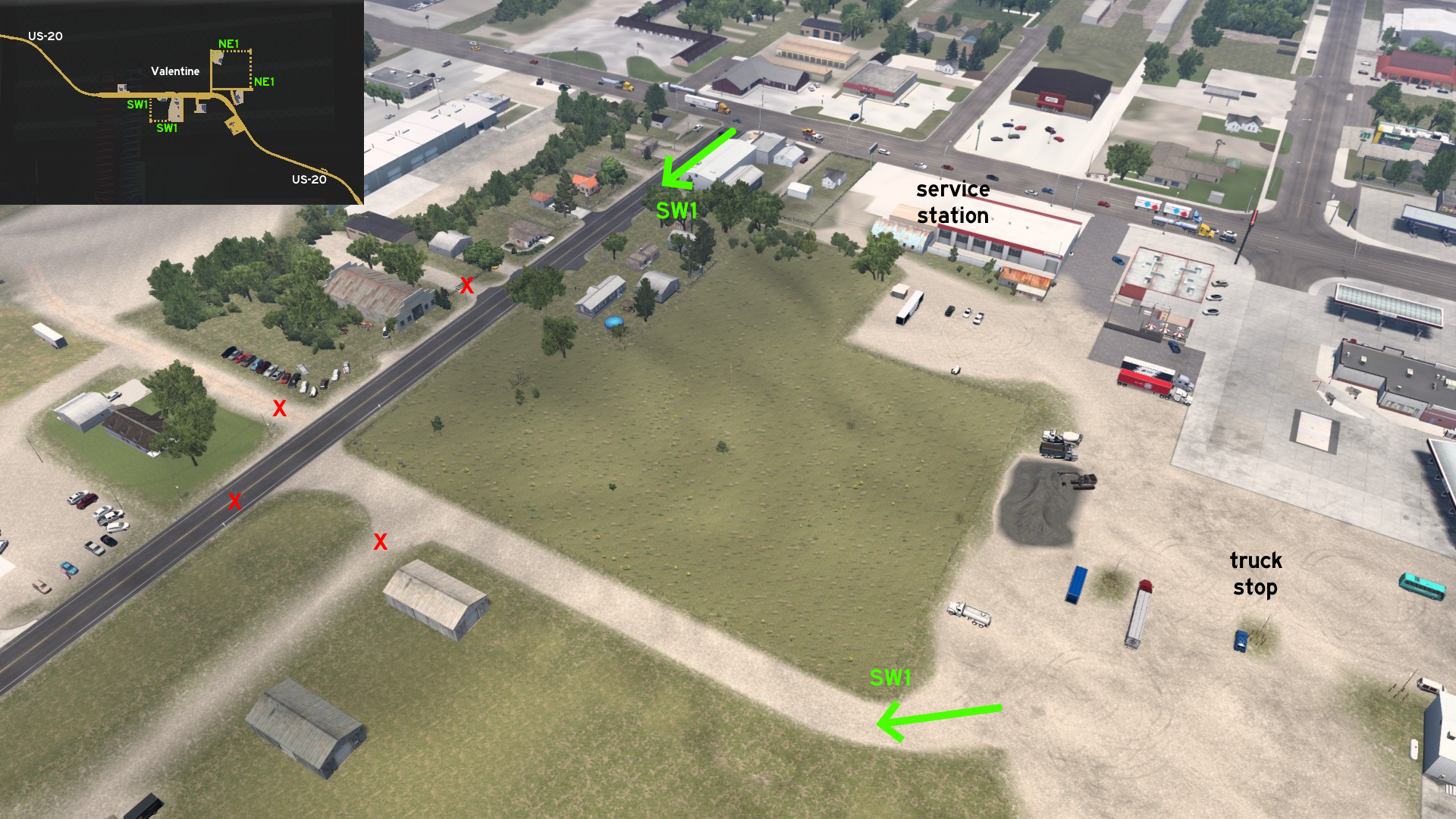 Leave the truck stop on US-20 from the southwest corner, take the dusty road until you reach Merritt Dam Road, and head north to return to the city center.
19th DLC, announced
Several truck wash locations were added to American Truck Simulator, possibly hinting a new feature. But different from the bus terminals and stops on Euro Truck Simulator 2, they were added as unmarked places here. This section will stay here until the related feature is released.
Iowa
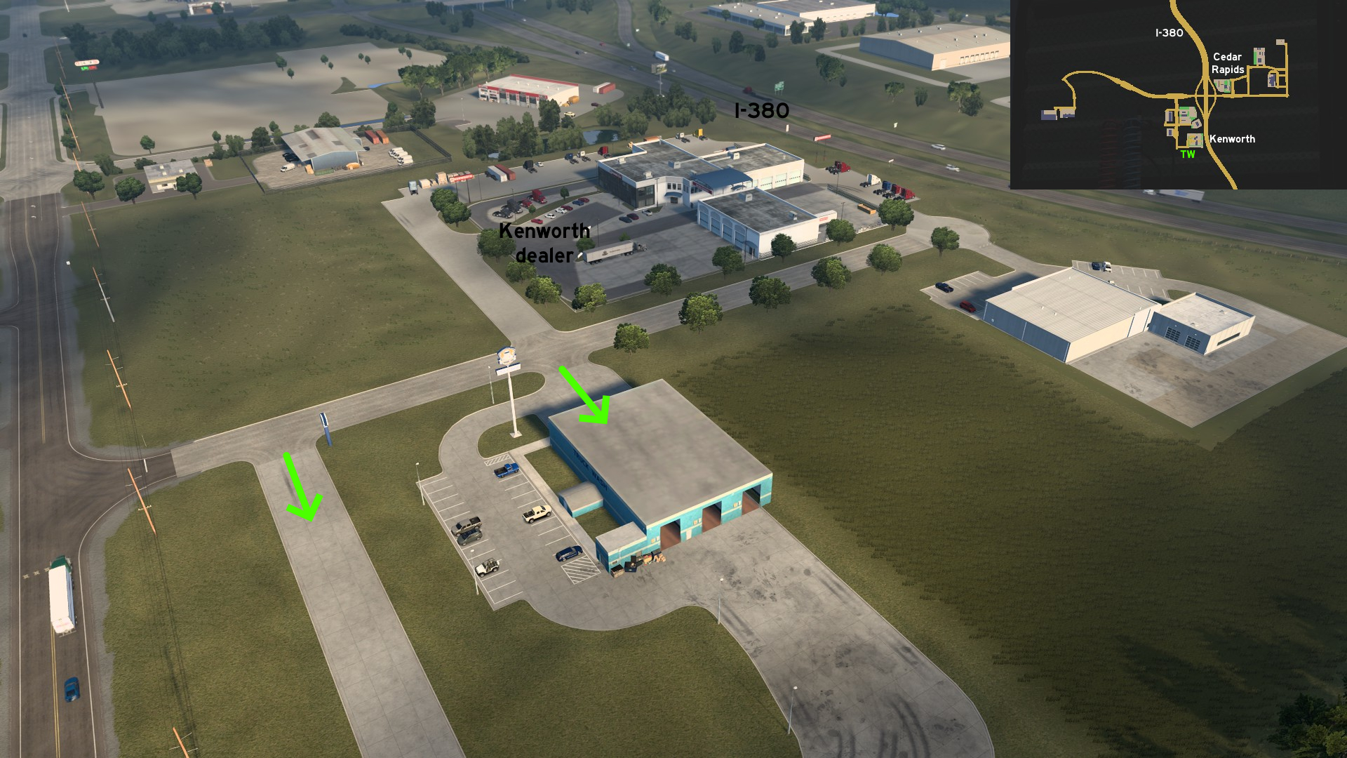 Cedar Rapids
South, across the road to Kenworth dealer
Discovery: olm823249, Applecorn
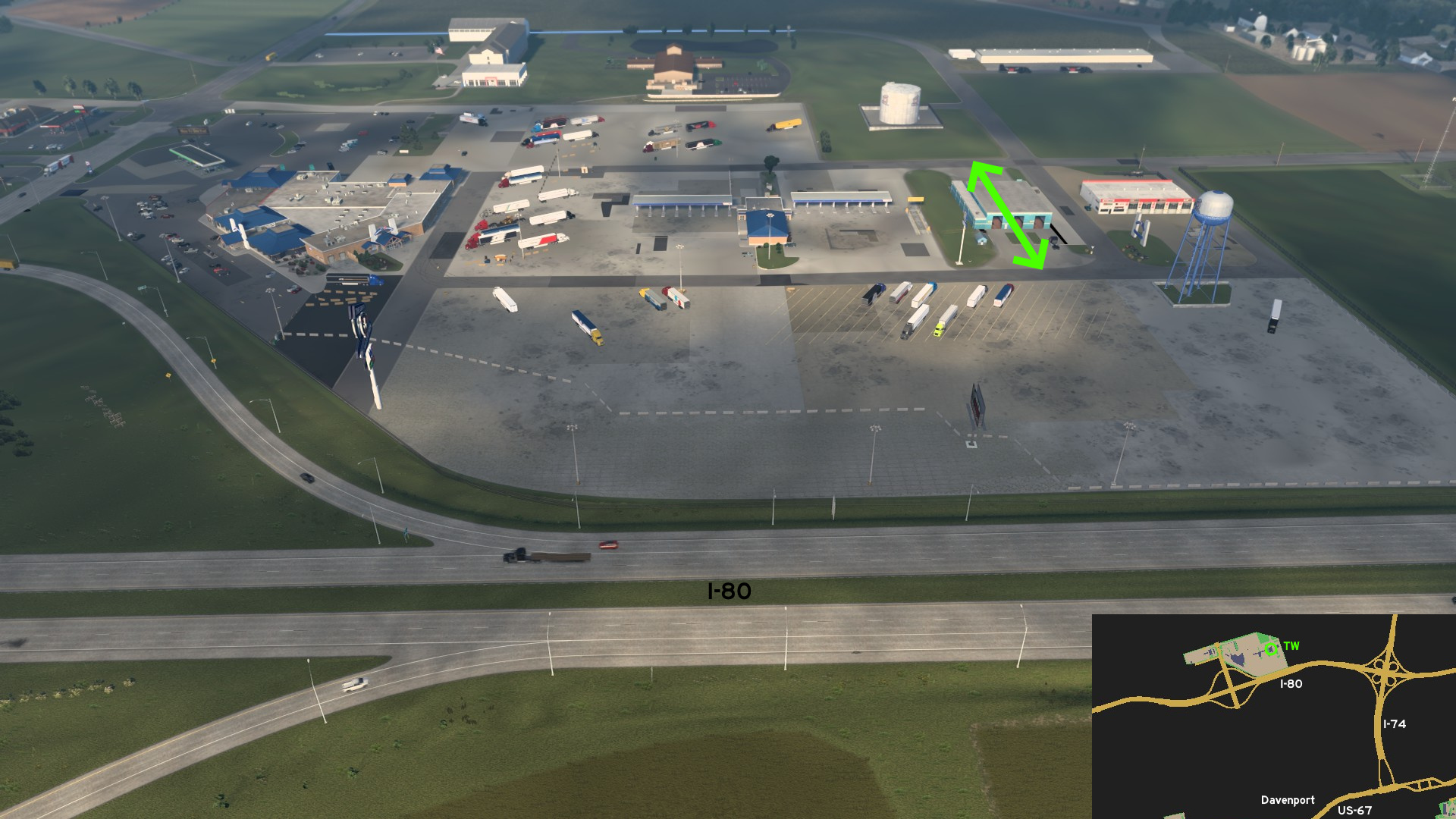 Davenport
North, on famous big I-80 truck stop.
Discovery: olm823249
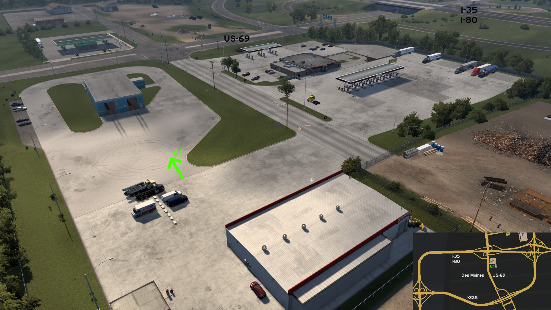 Des Moines
Central, service station between I-35 / I-80 and I-235, on US-69
Discovery: FelipeVinhao
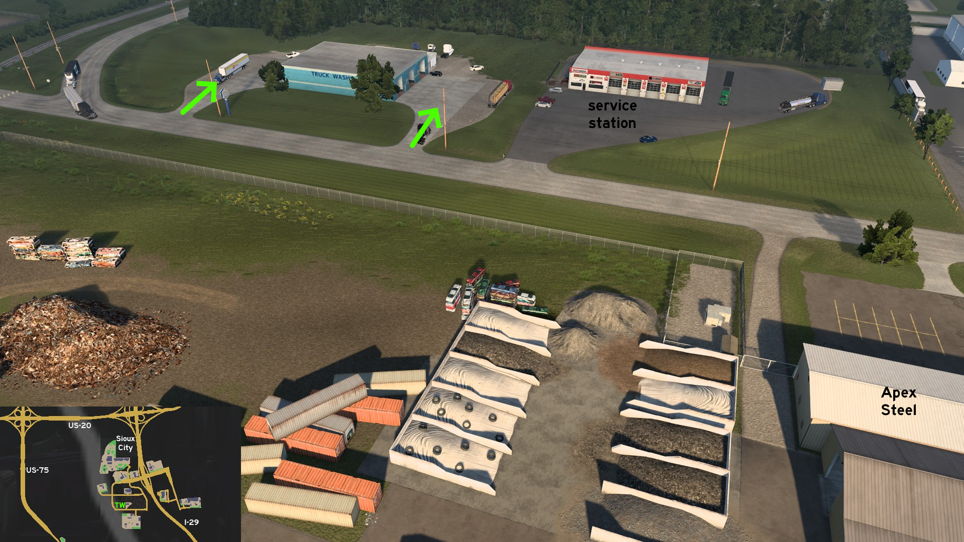 Sioux City
South of city, west of service station, northwest of Apex Steel
Discovery: olm823249
Nebraska
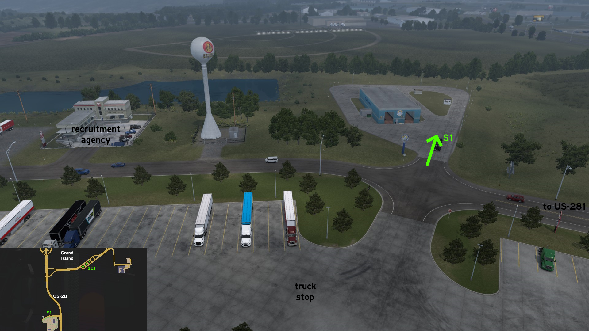 Grand Island
South, on US-281
Credits: Applecorn
The people who helped finding the unmarked roads listed here are in the credits for each city. Here's a list of all users helped us. Also thanks all users who aren't listed here, but paid us a visit.
17F
aarondinius
aclements
Ae3qe27u
airbornecowboy77
Alex Monamochamuch
AlfaPhoxtrot
A. P. 101 Gaming
ApatheticGorilla
Applecorn
aqweasd7
beta1hit
Binary
Birckablock
biromesyservilletas
blaze72003
buffalo_pete
CaptainFlint
Corran Horn
CrazyLithuanianHacker
crazy rocker
Crieris
Cyanlix
Cyclone
DDogg
dfad1ripe
DPT Wanderer
dutchheavener
aarondinius
aclements
Ae3qe27u
airbornecowboy77
Alex Monamochamuch
AlfaPhoxtrot
A. P. 101 Gaming
ApatheticGorilla
Applecorn
aqweasd7
beta1hit
Binary
Birckablock
biromesyservilletas
blaze72003
buffalo_pete
CaptainFlint
Corran Horn
CrazyLithuanianHacker
crazy rocker
Crieris
Cyanlix
Cyclone
DDogg
dfad1ripe
DPT Wanderer
dutchheavener
emeryradio
Epic Trucker Arch
ernst-ulrich.reichelt
ExaminerIan
FeteFatale
Foonty
Gardevoir
Genesai G
gg bb
Half-man half-amazing
Hedwig xo
Helen Keller
henrzman
House of Orange
HuskyDynamics
hydroxyquinoline
Ice_Tea_Zero
interlaken
jackabox miller
Jasper
JediCowboy
Jérôme
JSG4361
joshuatree37
kaia15
kettcardriverprofi
knightshift
Epic Trucker Arch
ernst-ulrich.reichelt
ExaminerIan
FeteFatale
Foonty
Gardevoir
Genesai G
gg bb
Half-man half-amazing
Hedwig xo
Helen Keller
henrzman
House of Orange
HuskyDynamics
hydroxyquinoline
Ice_Tea_Zero
interlaken
jackabox miller
Jasper
JediCowboy
Jérôme
JSG4361
joshuatree37
kaia15
kettcardriverprofi
knightshift
kubrick6719
kwolf55
Laffey
Lausambaychua
LikelyLeon
lizzard29rus
Makeleth
mattbman
Maxis2012
MikMinevi
mizho_himats1538
nathan67003
NEMEZIS
noob168
nywiigshachristian
olm823249
omni2226
Oni
OWLCAT
Ozzy
PaynZz ツ
phonixl
punkito
PWSmith1
residenTR
Richard_Stamos
RIP_C.Bennington#LP_Forever
kwolf55
Laffey
Lausambaychua
LikelyLeon
lizzard29rus
Makeleth
mattbman
Maxis2012
MikMinevi
mizho_himats1538
nathan67003
NEMEZIS
noob168
nywiigshachristian
olm823249
omni2226
Oni
OWLCAT
Ozzy
PaynZz ツ
phonixl
punkito
PWSmith1
residenTR
Richard_Stamos
RIP_C.Bennington#LP_Forever
Royal Fyre
[ru64] el giraffe
Silent Storm
Skorpionik
skunk940
skyfox122
Slovak Eagle
spiceenybaby
spy_track
sunlight
Supernovae
TechTWP
termin8r
TGM
thechief
TheElderThing
The Pitts
TheTexanHusky
THO-XVI
TruckerCarlos
TW
uratobuic
Volvo_EG
Washington_County
Wide Kemo
Zaroski
Zest
[ru64] el giraffe
Silent Storm
Skorpionik
skunk940
skyfox122
Slovak Eagle
spiceenybaby
spy_track
sunlight
Supernovae
TechTWP
termin8r
TGM
thechief
TheElderThing
The Pitts
TheTexanHusky
THO-XVI
TruckerCarlos
TW
uratobuic
Volvo_EG
Washington_County
Wide Kemo
Zaroski
Zest
More American Truck Simulator guides
- Hidden and unmarked roads - USA - WEST - updated 2026/02/20★ 5 (1.3k)38k views1.9k ♥73 minUpdated Feb 19
- The American Truckers Guide to everything!★ 5 (960)34k views1.5k ♥53 minUpdated Aug 16, 2020
- American Truck Simulator 100% Achievement-Guide [ENG]★ 5 (704)15k views1.3k ♥8 minUpdated May 16
- Все достижения American Truck Simulator + все DLC [100% Achievement-Guide] [upd: 15.05.26]★ 5 (1.2k)14k views1.7k ♥42 minRussianUpdated Jul 12
- Texas 100% Achievement-Guide [ENG]★ 5 (443)12k views595 ♥7 minUpdated May 16
- Washington - 100% Achievement-Guide [ENG]★ 5 (503)12k views532 ♥2 minUpdated Mar 24, 2023



This guide was created by its original author on the Steam Community. Are you the author and want it removed? Request removal.